
Heanor and Loscoe facts for kids
Quick facts for kids Heanor and Loscoe |
|
|---|---|
| Civil parish | |
 St Lawrence's Church, Heanor |
|

Heanor and Loscoe
|
|
| Area | 2.34 sq mi (6.1 km2) |
| Population | 17,251 (2011) |
| • Density | 7,372/sq mi (2,846/km2) |
| OS grid reference | SK 4347 |
| • London | 120 mi (190 km) SE |
| District |
|
| Shire county | |
| Region | |
| Country | England |
| Sovereign state | United Kingdom |
| Post town | HEANOR |
| Postcode district | DE75 |
| Dialling code | 01773 |
| Police | Derbyshire |
| Fire | Derbyshire |
| Ambulance | East Midlands |
| EU Parliament | East Midlands |
| UK Parliament | |
| Website | www.heanorloscoe |
Heanor and Loscoe is a civil parish (a local area with its own council) in the Amber Valley area of Derbyshire, England. It's mostly built-up with some countryside around it. In 2011, about 17,251 people lived here.
The parish is about 193 kilometres (120 miles) northwest of London. It's also about 16 kilometres (10 miles) northeast of Derby, the main city in the county. Heanor and Loscoe includes the market town of Heanor and other smaller areas. It shares borders with nearby places like Aldercar and Langley Mill, Codnor, Denby, Shipley, and Smalley.
Contents
- Discovering Heanor and Loscoe's Geography
- A Look at Heanor and Loscoe's History
- How Heanor and Loscoe is Managed
- People and Homes in Heanor and Loscoe
- Education in Heanor and Loscoe
- Community Life and Fun Activities
- Important Landmarks
- Getting Around Heanor and Loscoe
- Places of Worship
- Sports and Activities
- Notable People
- Images for kids
- External Sites
Discovering Heanor and Loscoe's Geography
Where is Heanor and Loscoe Located?
Size and Surroundings
Heanor and Loscoe parish is surrounded by several places in Derbyshire:
- To the north: Codnor, Langley Mill, and Woodlinkin.
- To the south: Heanor Gate, Smalley, and Shipley.
- To the east: Eastwood.
- To the west: Denby.
The area covers about 6.06 square kilometres (2.34 square miles). It's about 2.4 kilometres (1.5 miles) long and 3.2 kilometres (2 miles) wide. The parish is in the southeastern part of Derbyshire, close to the border with Nottinghamshire.
Main Towns and Villages
Most of the parish is built-up, but it also has rural areas and farmland. The main places to live are:
- Heanor: A town.
- Loscoe and Loscoe Grange: Villages.
- Marlpool: A part of Heanor.
- Langley: Another part of Heanor.
Exploring Heanor Town
Heanor is in the south-central part of the parish, sitting on a high ridge. It's the biggest town and gives the parish its name. Heanor has important services like food shops, a retail park, a market, churches, and schools. It also has industrial areas and most of the homes. Common Side is a smaller area about 0.4 kilometres (0.25 miles) southwest of Heanor.
Loscoe and Loscoe Grange Villages
These villages are about 1.6 kilometres (1 mile) northwest of Heanor. They have grown and now connect with the town. Loscoe and Loscoe Grange are mostly places where people live. They also have some small shops and factories. You can find a church, a nature reserve, and several factories here.
Marlpool Area
Marlpool is about 1.1 kilometres (0.67 miles) southeast of Heanor. It also blends into the town. This area is mostly homes, but it has small shops, a school, and churches.
Langley Area
Langley is about 1.1 kilometres (0.67 miles) east of Heanor. It connects with Heanor and Marlpool. Langley is mainly residential, with only a few services like a school and a church.
Major Roads
The main road through the parish is the A608. It goes from Annesley in Nottinghamshire to the city of Derby. This road cuts right through the center of Heanor. The A6007 road also goes through Heanor, overlapping with the A608 in some parts.
Natural Environment of Heanor and Loscoe
Landscape Features
The center of Heanor is on a high ridge. The land to the east is much lower, part of the Erewash Valley. Many roads leading to the town are quite steep. While mostly urban, the parish has green spaces, especially recreation areas. There's also farmland on the edges, particularly around Loscoe. Red River Local Nature Reserve is a special natural area in Loscoe. There are not many large groups of trees, but some small woods exist.
Geology and Rocks
The ground beneath the parish is made of different types of mudstones, siltstones, and sandstones. These rocks formed between 318 and 309.5 million years ago. The high ridge at Heanor and the area around Loscoe are especially rich in sandstone. The wider area has a history of coal and marl mining.
Waterways and Lakes
Bailey Brook is a smaller stream that flows into the River Erewash. It forms part of the parish's northeastern border. Loscoe Brook joins Bailey Brook after flowing through Loscoe village. Loscoe Dam is a human-made lake that has been here since medieval times. It's filled by Bailey Brook. Other lakes include Osbourne's Pond in Marlpool and the Red River Local Nature Reserve in Loscoe.
Land Height
The town center of Heanor sits on a high ridge, about 125-130 metres (410-427 feet) above sea level. Loscoe is around 95-100 metres (312-328 feet high). Langley's height varies from 65-105 metres (213-344 feet). The highest point in the parish is in western Loscoe, about 135 metres (443 feet) high. The lowest point is at Bailey Brook, around 62 metres (203 feet).
A Look at Heanor and Loscoe's History
What Do the Names Mean?
Only Heanor and Langley were mentioned in the Domesday Book in 1086. Heanor was called 'Hainoure', which likely meant 'The high ridge' because of its elevation. Langley was 'Langeleie', meaning 'long clearing'. Loscoe was first recorded in the late 1200s as 'Loftskou', meaning 'wood with a house'. Common Side got its name from Heanor Common in the 1600s. Marlpool appeared in the early 1800s. It's thought that marl (a type of soil) was mined there, and the holes filled with rainwater, creating a "marl pool."
From Ancient Times to Today
There isn't much evidence of very early human life in the parish itself. However, a stone axe from the Neolithic to Bronze Age (4000 BC to 701 BC) was found in Marlpool in 1953. The area was once part of Sherwood Forest's southern edge. Its high ground was good for defense. The first settlements, likely made of wattle and daub, were probably near today's Heanor Market Place.
There's proof of a Roman presence nearby. A major Roman road, Ryknield Street, was less than 3.2 kilometres (2 miles) away. This suggests the parish might have been part of the Roman road network. Later, Anglo-Saxons settled here, and many local names come from their language. Heanor became an important center because of its location. By the time of the Norman Conquest, it was well-developed and had a church, as recorded in the Domesday Book of 1086.
Loscoe was linked to the Draycott family. Their home, Loscoe Manor, was taken down in 1704. Henry Garnet, involved in the 1605 Gunpowder Plot, was born in Heanor. The Fletchers, a well-known family, owned coalmines in the 1600s. They lived in Heanor Hall. This hall later became a secondary school, Heanor Grammar, in 1893.
A school for children was built in Loscoe in 1895. Heanor Memorial Hospital was built in 1925 to honor local people who died in World War I. It was rebuilt in 2018. In 1986, a methane gas explosion happened at a Loscoe home. This led to new UK laws about gas safety from landfills.
How Heanor and Loscoe is Governed
In medieval times, Heanor was a large parish. Local matters were handled by the church and local courts. Loscoe was part of Heanor until 1844. After a new church was built, Loscoe and Codnor became separate parishes.
Later, in 1850, a local board was set up to manage public services in Heanor. This board eventually became an urban district in 1895. In 1899, Codnor and Loscoe rejoined Heanor Urban District. This district used the town hall as its main office.
In 1974, Heanor Urban District became part of the new Amber Valley district. Ten years later, in 1984, Heanor and Loscoe became a new civil parish. In 1987, the Heanor and Loscoe parish council decided to become a town council.
The Local Economy's History
In medieval times, Loscoe Dam was used to power a corn mill and provide fish. In the late 1500s, it powered an iron works. By the mid-1800s, it was a corn mill again. Later, Ormonde Colliery operated nearby from 1908 to 1970.
Loscoe Colliery opened in the 1830s. The Butterley Company later owned this mine and others, known as the New Langley group of collieries. After World War II, coal mining became nationalized. Factories in the area included silk and lace factories, brickworks, and pottery works.
Places of Worship
Church of England
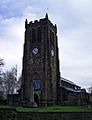
Heanor had a church even before the Domesday Book. A new church opened in 1297, first called St Michael's, then later St Lawrence's. It was rebuilt in 1868 and again in 1981, but the tower remained.
Loscoe became separate from Heanor in 1844. St James's Church served Loscoe and Codnor. In 1927, Loscoe got its own church, St. Luke's, built in 1936-37. All Saints church was built in 1895 for people in Marlpool and Langley.
Other Religions
Loscoe was an early center for non-conformist groups (Protestants not part of the Church of England). A Presbyterian chapel opened in 1722. It was later used by Baptists. Methodists started worshipping in Heanor in 1810. Other groups like Independents and Quakers also met in the area. Marlpool cemetery opened in 1858 and has two chapels.
Transport Links
The Midland Railway built a line to Heanor railway station in 1890. Another line was built by the Great Northern Railway (GNR) in 1891. Marlpool station also opened in 1891. All these stations closed by 1963.
The Nottinghamshire and Derbyshire Tramways Company opened a tramway in 1913. It went through Heanor and Loscoe. The tram service stopped in 1933. The depot later became the headquarters for the Trent Barton bus company.
How Heanor and Loscoe is Managed
Local Government Bodies
Heanor and Loscoe parish is run by a town council. This is the first level of local government.
The wider area is managed by Amber Valley Borough Council. Derbyshire County Council provides larger services for the whole county.
Voting and Representation
For voting, the parish is split into three areas: Heanor and Loscoe, Heanor West, and Heanor East. These are part of the Amber Valley district. For county elections, it's in the Heanor Central and Greater Heanor areas. It's also part of the Amber Valley area for national Parliament elections.
People and Homes in Heanor and Loscoe
Population Numbers
In 2011, Heanor and Loscoe parish had 17,251 residents. This was an increase from 16,040 people in 2001. Most people (62%) are working age adults (18-64 years old). About 21% are infants to teenagers, and 17% are elderly (65 years and older).
Jobs and Work
Many local people aged 18 and over have regular jobs (69.7%). About 30.3% are not working, with 15.9% of those being retired. Most residents work in manufacturing, retail, vehicle repair, construction, and health and social care (59%).
Homes and Travel
In 2011, there were over 7,200 homes in the parish. Most homes are semi-detached (38%), then detached (28%), or terraced (27%). The rest are flats or caravans. Most homes (over 5,200) are owned by the people living in them. Most households (76%) have a car or van.
Education in Heanor and Loscoe
There are several nursery and primary schools in the area:
- Heanor and Loscoe Grange: Howitt Primary
- Loscoe: Loscoe Church of England (CofE) Primary and nursery
- Marlpool: Coppice Primary, Mundy CofE Juniors, Marlpool Juniors
- Langley: Laceyfields Academy
A secondary school, Heanor Gate Science College, is located just outside the parish boundary in Smalley.
Community Life and Fun Activities

Local Shops and Businesses
Heanor has many public facilities and businesses. These include food shops, a retail park, a medical center, and pubs. Industrial areas with small and medium-sized businesses are located between Heanor and Loscoe. The Trent Barton bus depot is also here.
Events and Community Groups
The Heanor and Loscoe council organizes various events. These include annual May Day celebrations, band concerts, pantomime shows, and Christmas lights festivities. The Wilmot Street Centre in Heanor is a community building used by local groups.
Recreation and Play Areas
The town has several recreation grounds and playing fields. There's also the Red River Nature Reserve in Loscoe and a memorial park in Heanor. Many play areas are available for children and young people. There are also community allotment spaces in Loscoe and Marlpool for gardening.
Exploring the Area (Tourism)
The Nutbrook Trail is a 16-kilometre (10-mile) path where you can cycle or walk without traffic. It briefly enters the parish south of Marlpool. This trail is also part of Route 67 of the National Cycle Network, which is 200 kilometres (124 miles) long.
Important Landmarks
Protected Buildings and Areas
Special Buildings
Listed Buildings
There are ten buildings in the parish that are important for their architecture. St Lawrence's Church in Heanor is a Grade II* listed building, meaning it's very special. The others are Grade II listed. These include houses, a former bank, the town hall, a former college, and a cemetery monument.
Protected Natural Areas
Green Belt Land
Most of the parish, except for the built-up areas, is part of the South East Derbyshire green belt. This is a protected area of countryside that stops towns from growing too much.
Local Nature Reserves
An area of woodland near Bailey Brook Marsh is a Local Wildlife Site. This means it's a high-quality natural area, but it doesn't have strict legal protections. However, it's considered important for planning decisions. The Red River Local Nature Reserve in Loscoe is another special natural site.
War Memorials
Several memorials in the parish remember local people who served in World War I and World War II:
- The William Gregg VC Leisure Centre is named after a local soldier who won the Victoria Cross for bravery.
- A World War I memorial tablet, also honoring William Gregg, is in Heanor Cemetery.
- Another memorial tablet for William Gregg is in Heanor Park.
- Heanor Memorial Health Centre has several plaques.
- Dedication boards are at the Town Hall.
- Artefacts are at St Lawrence's Church.
- Memorial benches from World War I are in Heanor Memorial Park and Red River Nature Reserve.
Getting Around Heanor and Loscoe
Bus Services
Heanor town center is easy to reach by bus. It's a key stop for buses traveling to places like Chesterfield, Derby, Nottingham, Mansfield, and Ripley. The Rainbow One bus route, run by Trent Barton, goes between Nottingham and Ripley. Buses run every half hour on weekdays and Saturdays. The H1 route also run by Trent Barton, goes between Alfreton and Derby via Heanor and Loscoe.
Train Services
There isn't a train station directly in the parish. However, the Erewash Valley railway line runs along the eastern edge of Langley. Langley Mill railway station is about 2.9 kilometres (1.8 miles) east of Heanor center on this line.
Places of Worship

There are three Anglican churches (part of the Church of England). St Lawrence's in Heanor dates from the 1200s and is on the highest point in Heanor. St Luke's Church is in Loscoe, and All Saints is in Marlpool. Other religious groups in the parish include Baptists, Christadelphians, United Reformists, Methodists, and Jehovah's Witnesses. There is also a cemetery in Marlpool.
Sports and Activities
The William Gregg VC Leisure Centre in Heanor is a large sports hall and gym.
The Town Ground in Common Side, south of Heanor, has fields for cricket and football. Nearby are the Lockton Avenue playing fields. There's also a bowling green and football field at the Miner's Welfare.
Charles Hill Recreation Ground in Loscoe is an all-weather sports facility. You can play football, cricket, and basketball there. It's also accessible for wheelchairs.
Heanor Town is a local association football team. They play at the Town Ground.
Notable People
- Further information: Heanor#Notable residents and Loscoe#Notable residents
Images for kids
-
St Lawrence's Church, Heanor
External Sites
- Rights of way in Heanor and Loscoe
- Community gallery
- Heanor video journal #1
- Heanor video journal #2
