
Eastwood, Nottinghamshire facts for kids
Quick facts for kids Eastwood |
|
|---|---|
| Town and civil parish | |
 The Sun Inn, Eastwood town centre. |
|
Parish map |
|

Eastwood
|
|
| Area | 1.61 sq mi (4.2 km2) |
| Population | 10.927 (2021 - civil parish) |
| • Density | 7/sq mi (2.7/km2) |
| OS grid reference | SK 46684 47005 |
| • London | 116 mi (187 km) SSE |
| District |
|
| Shire county | |
| Region | |
| Country | England |
| Sovereign state | United Kingdom |
| Post town | NOTTINGHAM |
| Postcode district | NG16 |
| Dialling code | 01773 |
| Police | Nottinghamshire |
| Fire | Nottinghamshire |
| Ambulance | East Midlands |
| EU Parliament | East Midlands |
| UK Parliament |
|
Eastwood is a town in Nottinghamshire, England. It is about 8 miles (13 km) northwest of Nottingham. Long ago, it was a busy coal mining town. Eastwood is mentioned in the famous Domesday Book, which was a big survey of England made in 1086. The town grew very quickly during the Industrial Revolution, a time when new factories and machines changed how people lived and worked. The Midland Railway company, which built many train lines, was started here. Eastwood is also famous as the birthplace of the well-known writer D. H. Lawrence.
Contents
History of Eastwood
The name "Eastwood" comes from old words. "East" means east, and "Þveit" (pronounced 'thwayt') is an Old Norse word for a "cleared meadow" or "clearing in a wood." So, Eastwood likely means 'eastern clearing'. It might have been a clearing made by Vikings in Sherwood Forest a long time ago.
People lived in the area around Eastwood even in ancient times, during the Stone Age. The town grew where it is because of good farming land, the nearby River Erewash, and especially because of the large amounts of coal that were easy to mine.
Eastwood is mentioned in the Domesday Book from 1086. It was called Estewic then. The book said it had some land and woodland, but it was mostly empty.
Later, in the 12th century, during a civil war called The Anarchy, the land around Eastwood became part of the Crown's property. Much of it was later given to the Grey family from Codnor Castle. For many years, farmers rented land to grow crops, and animals grazed on shared land called common pasture.

In 1603, when James VI of Scotland became King James I of England, Eastwood was a small village with about 170 people. It stayed small until the late 1700s. In 1779, the Trent Navigation Company opened the Erewash Canal. This was one of England's first man-made waterways. It connected Eastwood to the River Trent and Nottingham, which helped the local coal mining industry grow very fast. Other businesses like knitting, milling grain, making pottery, brewing, rope making, and brick making also started up.
The town expanded quickly during the Industrial Revolution. In the 1800s, Eastwood's population grew more than any other area in Nottinghamshire. By 1880, about 4,500 people lived there. Factories were built as more people moved from farms to towns for work.
In 1832, an important meeting at the Sun Inn (built in 1750) led to the creation of the Midland Counties Railway. This company built a train line from Pinxton to Leicester. More industries came with the opening of Moorgreen Colliery (a coal mine) in 1868. By 1875, there was so much demand for coal that a railway station was built in Eastwood, with trains going to Nottingham.
D. H. Lawrence was born in Eastwood in 1885. He wrote about the local area in many of his books, especially The White Peacock. There were ten coal mines close to his home, and most men in the town worked as colliers (coal miners). Even though the coal boom ended during Lawrence's childhood, Eastwood kept growing. Nottingham Road became a main shopping area, and in 1908, the local council opened its offices. However, there were few jobs outside of coal mining. Most women stayed home, and boys often couldn't wait to turn fourteen so they could start working in the mines. In the early 1900s, trams offered new transport to Nottingham, Ripley, and Heanor. Lawrence lived near the tram line and even called it the most dangerous in England!
Eastwood's coal, metal, rope, wire, and farm products were very important during both world wars. In the Second World War, Eastwood sent soldiers to the Sherwood Foresters Regiment. A memorial on Nottingham Road remembers the people from Eastwood who died in both wars.
In 1946, the coal industry was taken over by the government, a process called nationalisation. The new National Coal Board used Eastwood Hall as its main office. This building later became a hotel. At its busiest in 1963, Moorgreen Colliery alone produced one million tons of coal! However, the last coal mine in the area closed in 1985.

Today, tourism is growing in Eastwood. Lawrence's birthplace is now a museum. There's also a "Blue Line Trail" painted on the pavement. This line guides visitors to eleven interesting local spots, including three of Lawrence's former homes. This trail was the first of its kind in England, inspired by the Freedom Trail in Boston, USA.

Local Government

The local council for Eastwood, called the Urban District Council, became part of Broxtowe District Council in 1974. In 1977, Broxtowe was given "borough" status, becoming the Borough of Broxtowe. The current mayor is Jackie Williams.
Parliamentary Representatives
The Eastwood area is part of the Ashfield constituency for the UK Parliament. The current Member of Parliament (MP) for Ashfield is Lee Anderson, who was elected in 2019.
Part of the Greasley area is also in the Broxtowe constituency. The current MP for Broxtowe is Juliet Campbell, elected in 2024.
Local Councils
Eastwood also has its own local councils, including Eastwood Town Council and Greasley Council. These councils deal with local matters for their areas.
Geography of Eastwood
Eastwood is surrounded by gentle hills and countryside. It is 8 miles (13 km) northwest of Nottingham and close to the border with Derbyshire.
...I was born nearly forty-four-year ago, in Eastwood, a mining village of some three thousand souls about eight miles from Nottingham, and one mile from the small stream, the Erewash, which divides Nottinghamshire from Derbyshire. It is hilly country, looking west to Crich and towards Matlock, sixteen miles away and east and northeast towards Mansfield and the Sherwood Forest district. To me it seemed, and still seems an extremely beautiful countryside, just between the red sandstone and oak trees of Nottingham and the cold limestone, the ash trees, the stone fences of Derbyshire
– D.H. Lawrence, 1929 Nottingham & the Mining Country
The land here has layers of coal, shale, mudstone, and sandstone. On top of these layers is yellow clay. The River Erewash also leaves behind alluvial deposits, which are like rich soil, as it flows north to south.
The town's main road is Nottingham Road. It runs along a ridge from northwest to southeast and has many shops. Going uphill to the east, it leads to the A610 road towards Nottingham, the M1 motorway, and a large shopping area called Giltbrook Retail Park. This park has a big IKEA store. At the western end of Eastwood, there's a large traffic island around the Sun Inn pub. From here, roads lead north to Brinsley, west to Heanor, and south through Church Street into New Eastwood.
Eastwood is still surrounded by farms, woods, and fields. Just half a mile (1 km) to the west, the River Erewash forms the border between Nottinghamshire and Derbyshire. Next to the river, the Erewash Canal connects to the River Trent.
A large hill north of the town is known locally as "dot hill" or "dirt hill." This land was once a slag heap from the mines but has been cleaned up and made into green space.
Population Information
In 2001, the town of Eastwood, including areas outside the main parish, had a total population of 18,732 people.
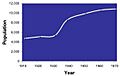
We can see how the population changed from 1911 to 1971 because Eastwood was a special local government area during that time.

| Population growth in Eastwood since 1911 | |||||||||||||||||||
|---|---|---|---|---|---|---|---|---|---|---|---|---|---|---|---|---|---|---|---|
| Year | 1911 | 1921 | 1931 | 1939 | 1951 | 1961 | 1971 | ||||||||||||
| Population | 4,692 | 5,069 | 5,360 | 8,581 | 9,894 | 10,607 | 10,856 | ||||||||||||
| Source:A Vision of Britain through Time | |||||||||||||||||||
In 1951, about 11.5% of the people in Eastwood worked in mining or quarrying. By 2001, this number had dropped a lot, to only 0.15%. This shows how much the town changed after the mines closed.
In the 2001 census, over 98% of the people in Eastwood identified as "White: British." The average for England was 87%.
In the 2011 census, the population of the civil parish was 10,695. This increased slightly to 10,927 residents in the 2021 census.
Important Landmarks


The Buildings is a housing area with about 300 terraced cottages where miners used to live. They were built in the 1860s. These homes were saved from being torn down by a special council plan, which even won an award in 1977.
Colliers' Wood is a 14-hectare (about 35-acre) community woodland. It was created in 1996/97 to bring back some of the natural woodland and fields that were lost due to mining. Over 17,500 trees and hedges were planted, and two ponds were made. The footpaths are made from reclaimed shale. Many different birds live here, including mute swans, goldfinches, and skylarks.
The War Memorial was put up in 1921 to remember the men from Eastwood who died in World War I. Later, names from World War II were added. It's a tall, pointed stone monument called an obelisk, made of Italian marble.
The Library, opened in 1975, has many books by and about D. H. Lawrence. You can also see Lawrence's old desk and the headstone from his grave there.
Greasley Castle was built around 1341. Today, only parts of the old castle remain, hidden within the Greasley Castle Farmhouse, which was built around 1800.
The Blue Line Trail is a painted line on the pavement that guides visitors to places connected to the author D.H. Lawrence. These include the D.H. Lawrence Birthplace Museum, which shows how a working-class Victorian house looked, and other homes where Lawrence lived.
Eastwood Hall used to be the main office for British Coal. Now, it's a hotel and conference center.
The Man in Space pub was built in the 1960s. It was briefly seen in a movie called Carry on at Your Convenience. It has since closed and is now a Co-op store.
Transport in Eastwood
The M1 motorway is very close to Eastwood, with junctions 26 and 27 nearby.
Eastwood has bus services provided by Trent Barton and Nottingham County Council.
- 33: Ilkeston – Heanor – Eastwood – Kirkby – Sutton – Mansfield
- 34: Ilkeston – Heanor – Eastwood – Kimberley – Hucknall
- Rainbow One: Nottingham – Kimberley – Eastwood – Heanor and Ripley or Jacksdale/Selston and Alfreton
- 532: Eastwood – Moorgreen – Selston
- 535: Eastwood circular
A bus trip to Nottingham on the Rainbow One takes about 40 minutes. A trip to Hucknall on the 34 takes about 30 minutes.
The closest train station is at Langley Mill. From there, you can catch trains to Nottingham, Sheffield, Chesterfield, and Manchester.
The East Midlands Airport is about 13 miles (21 km) away, or 19 miles (31 km) by road.
Education in Eastwood
There are five primary schools in the Eastwood area:
- Florence Nightingale Academy
- Greasley Beauvale Primary School (which D.H. Lawrence attended!)
- Lawrence View Primary School
- The Priory Catholic Primary School
- Springbank Academy (formerly Eastwood Infant and Junior School)
Most older students from the area go to Hall Park Academy, which used to be called Eastwood Comprehensive School.
Eastwood Skills Shop offers different courses, like IT, Arts & Crafts, Spanish, and Interior Design.
Eastwood Library, in the town center, lets you borrow books. It also has free internet access and other information services.
Eastwood Community Sports Centre has a sports hall with four courts and several football pitches.
Religious Buildings
St Mary's Parish Church has been a church site since 1250. Parts of the original building still remain. It was rebuilt and enlarged over the years, and after a fire in 1963, only the tower was left. The rest of the church was rebuilt and opened in 1967.

Beauvale Priory was founded in 1343. It was one of nine Carthusian monasteries in England. The monks followed strict rules. The monastery was closed in 1539, but it appears in Lawrence's book The White Peacock as "the Abbey."
Other churches in the area include:
- Assemblies of God Church, Nottingham Rd
- Our Lady of Good Counsel RC Church, Nottingham Rd
- Church of Jesus Christ of Latter Day Saints, Derby Rd
- Eastwood Baptist Church, Percy St
- Eastwood Church of Christ, Seymour Road
Sports in Eastwood
Eastwood has its own non-league football club, Eastwood C.F.C., which was started in 2014. They play at Coronation Park.
Eastwood Town Cricket Club plays in the Gunn & Moore South Notts League.
The Nottinghamshire pool team plays its home games at Phoenix Cue Sports on Mansfield Road.
Eastwood Antz Basketball Club plays at Eastwood Sports Centre.
Famous People from Eastwood
- D. H. Lawrence (1885–1930) was a famous author born in Eastwood. His birthplace and homes now attract visitors from all over the world. Many of his best-known books describe Eastwood and its culture. He even wrote poems in the local dialect.
- Andi Wolf (born 1966) grew up in Eastwood. He became an actor, singer, and musician. He still works and sometimes visits Eastwood.
- Jeffrey (Jeff) Astle (1942–2002) was an English footballer born in Eastwood. He played for West Bromwich Albion and the England team.
- Tony Woodcock (born 1955) was also born in Eastwood. He played 42 games for England and scored 16 goals. He won the European Cup and the League Cup with Nottingham Forest in 1979.
- Several cricket players, including Thomas Limb and William Rigley, were born in the area.
New Developments
The Giltbrook Retail Park, about 1.5 miles (2.5 km) southwest of Eastwood, is a large shopping center that opened in 2008. It has a huge IKEA store and other shops like Boots, Pets at Home, Next, and Starbucks.
Culture and Community
The Eastwood Collieries' Male Voice Choir started in 1919. They appeared on BBC television in 1963 and are one of the oldest surviving choirs from a mining area in the UK.
The Eastwood Arcadians are a local marching band.
The local newspaper is the Eastwood and Kimberley Advertiser.
The Eastwood Theatre hosts local, national, and international shows, including dance, music, and drama.
Arms
|
Images for kids
-
Eastwood – population trend, 1911 to 1971
See also
 In Spanish: Eastwood (Nottinghamshire) para niños
