Hendry County, Florida facts for kids
Quick facts for kids
Hendry County
|
||
|---|---|---|

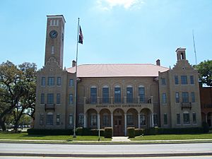
The Hendry County Courthouse in LaBelle in 2010.
|
||
|
||

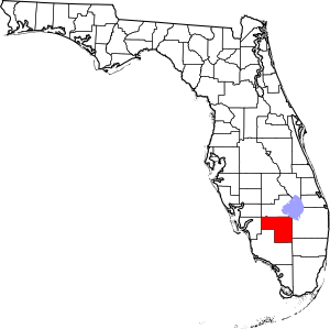
Location within the U.S. state of Florida
|
||
 Florida's location within the U.S. |
||
| Country | ||
| State | ||
| Founded | May 11, 1923 | |
| Named for | Francis A. Hendry | |
| Seat | LaBelle | |
| Largest city | Clewiston | |
| Area | ||
| • Total | 1,190 sq mi (3,100 km2) | |
| • Land | 1,153 sq mi (2,990 km2) | |
| • Water | 37 sq mi (100 km2) 3.1%% | |
| Population
(2020)
|
||
| • Total | 39,619 | |
| • Density | 33.29/sq mi (12.85/km2) | |
| Time zone | UTC−5 (Eastern) | |
| • Summer (DST) | UTC−4 (EDT) | |
| Congressional district | 25th | |
Hendry County is a county located in the Florida Heartland region of Florida, a state in the United States. In 2020, about 39,619 people lived here. This was a small increase from 2010. Most people in Hendry County are of Hispanic or Latino background. The main town, or county seat, is LaBelle.
Hendry County is part of the Clewiston micropolitan area. This area also includes Glades County. Together, these counties are part of a larger area called the Cape Coral-Fort Myers-Naples Combined Statistical Area.
Contents
History of Hendry County
Early People and Settlements
Long ago, around 10,000 B.C.E., early people moved into Florida. Later, the Glades culture lived in southern Florida from about 500 B.C.E. to 1500 C.E. We know they were here because of old sites like Clewiston Mounds. When Europeans first arrived in the 1500s, the Calusa and Mayaimi tribes lived in this area.
In the early 1800s, a French trader named Pierre Denaud set up a trading post. This was in the area where LaBelle is today. During the Seminole Wars, U.S. soldiers built a fort in 1838. They named it Fort Denaud after Pierre Denaud. A few years later, Fort Thompson was built. These forts were the first lasting settlements in what is now Hendry County.
At first, much of this area was covered by the Florida Everglades. It was also often flooded. This made it hard to build towns, so only cattle ranching was common. But by 1881, efforts began to drain the land. The first post office opened at Fort Thompson in 1884.
Forming the County
In 1887, Lee County was created, and it included land that is now Hendry County. The town of LaBelle started around 1889 or 1890. It was planned by Francis A. Hendry, who was a cattle rancher and politician. He also served in the Confederate States Army during the American Civil War.
Around 1900, fishermen started building camps near Lake Okeechobee. This area later became Clewiston. In 1911, LaBelle became the oldest official town in modern-day Hendry County. That same year, the U.S. government created the Big Cypress Indian Reservation here.
By the early 1920s, people in eastern Lee County wanted their own county. They were tired of how far they had to travel to Fort Myers, the county seat. So, on May 11, 1923, the Florida Legislature created Hendry County. It was named after Francis A. Hendry. LaBelle was chosen as the county seat.
Growth and Development
In 1924, residents voted to spend money on roads and a new courthouse. The courthouse was finished in 1927. It is now a historic place. In 1925, Clewiston also became an official city.
In the mid-1920s, a major highway was completed. It connected Fort Myers to Palm Beach and passed through Hendry County. This made travel much easier. A new train service also started in 1927. Hendry County was affected by two big hurricanes in 1926 and 1928. However, the damage was less severe than in other areas around Lake Okeechobee.
During World War II, a British flying school operated at Riddle Field in Clewiston. Over 1,800 Royal Air Force pilots were trained there. In 1961, the Herbert Hoover Dike was finished. This important project helped control water levels around Lake Okeechobee. Former president Herbert Hoover even gave a speech in Clewiston for its dedication.
Geography of Hendry County
Hendry County covers about 1,190 square miles. About 1,153 square miles is land, and 37 square miles (3.1%) is water. The county borders Lake Okeechobee. The Lake Okeechobee Scenic Trail goes through Hendry County. This county is the southernmost county in the U.S. that does not have an ocean coast or an international border.
Neighboring Counties
- Glades County - north
- Martin County - northeast
- Okeechobee County -
northeast (where five counties meet in Lake Okeechobee) - Palm Beach County - east
- Broward County - southeast
- Collier County - south
- Lee County - west
- Charlotte County - west
People of Hendry County
| Historical population | |||
|---|---|---|---|
| Census | Pop. | %± | |
| 1930 | 3,492 | — | |
| 1940 | 5,237 | 50.0% | |
| 1950 | 6,051 | 15.5% | |
| 1960 | 8,119 | 34.2% | |
| 1970 | 11,859 | 46.1% | |
| 1980 | 18,599 | 56.8% | |
| 1990 | 25,773 | 38.6% | |
| 2000 | 36,210 | 40.5% | |
| 2010 | 39,140 | 8.1% | |
| 2020 | 39,619 | 1.2% | |
| 2023 (est.) | 43,333 | 10.7% | |
| U.S. Decennial Census 1790-1960 1900-1990 1990-2000 2010-2019 |
|||
| Race | Pop 2010 | Pop 2020 | % 2010 | % 2020 |
|---|---|---|---|---|
| White (NH) | 13,650 | 12,089 | 34.87% | 30.51% |
| Black or African American (NH) | 5,057 | 4,195 | 12.92% | 10.59% |
| Native American or Alaska Native (NH) | 580 | 155 | 1.48% | 0.39% |
| Asian (NH) | 275 | 339 | 0.7% | 0.86% |
| Pacific Islander (NH) | 11 | 4 | 0.03% | 0.01% |
| Some Other Race (NH) | 49 | 120 | 0.13% | 0.3% |
| Mixed/Multi-Racial (NH) | 275 | 605 | 0.7% | 1.53% |
| Hispanic or Latino | 19,243 | 22,112 | 49.16% | 55.81% |
| Total | 39,140 | 39,619 |
In 2020, there were 39,619 people living in Hendry County. There were 12,878 households and 9,378 families.
In 2000, there were 36,210 people. The population density was about 31 people per square mile. The county's population was made up of different groups. About 66% were White, 14.75% Black or African American, and 0.8% Native American. About 39.6% of the population was Hispanic or Latino.
In 2000, about 40.2% of households had children under 18. The average household had about 3 people. The average family had about 3.4 people. The median age in the county was 30 years old.
Population in 2010
In 2010, the population of Hendry County was 39,140. The population included about 34.9% non-Hispanic white people. About 13.4% were Black or African American. About 49.2% of the population was Hispanic or Latino.
Education in Hendry County
The School Board of Hendry County (SBHC) manages public schools in the county. There are six elementary schools, with three in Clewiston and three in LaBelle. There are also two middle schools, one in Clewiston and one in LaBelle. Hendry County has two high schools: Clewiston High School and LaBelle High School.
The SBHC also runs the Montura Early Learning Center for younger children. There is also a special school called Ahfachkee School. It is located on the Big Cypress Indian Reservation.
Libraries in Hendry County
Hendry County has a library system called the Hendry County Library Cooperative. It includes the Clewiston Public Library (now called the Harry T. Vaughn Library), the Harlem Library, and the Barron Library in LaBelle. The Clewiston Public Library started in 1941. Its goal is to provide books and information for everyone.
Colleges and Universities
There are not many colleges directly in Hendry County. Florida SouthWestern State College has a small campus in LaBelle. However, nearby counties like Collier and Lee have more colleges. These include Ave Maria University and campuses of Florida SouthWestern State College.
Archaeology
- Tony's Mound
Communities in Hendry County
Cities
Census-Designated Places
These are areas that are like towns but are not officially incorporated as cities.
- Fort Denaud
- Harlem
- Montura
- Pioneer
- Port LaBelle (Pt LaBelle units 1-9)
Other Unincorporated Communities
These are smaller communities that are not officially part of a city or census-designated place.
- Banyan Village (Pt LaBelle units 10-13)
- Everhigh Acres
- Felda
- Flaghole (also known as Seven K Estates)
- LaDeca Acres
- Midway Acres
- Port LaBelle Acreage
- Wheeler Road
Transportation in Hendry County
Roads
Airports
- Airglades Airport
- LaBelle Municipal Airport
See also
 In Spanish: Condado de Hendry para niños
 | Victor J. Glover |
 | Yvonne Cagle |
 | Jeanette Epps |
 | Bernard A. Harris Jr. |


