
Hidden Lake Peaks facts for kids
Quick facts for kids Hidden Lake Peaks |
|
|---|---|

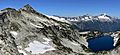
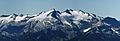
Hidden Lake Peaks from the east near Cascade Pass
|
|
| Highest point | |
| Elevation | 7,088 ft (2,160 m) |
| Prominence | 1,008 ft (307 m) |
| Geography | |

Hidden Lake Peaks
Location in Washington (state)

Hidden Lake Peaks
Location in the United States
|
|
| Location | Skagit County, Washington, U.S. |
| Parent range | North Cascades |
| Topo map | USGS Eldorado Peak |
| Type of rock | Granite |
| Climbing | |
| Easiest route | Hiking trail to lookout Scrambling class 2 to summit |
The Hidden Lake Peaks are a group of mountains in the North Cascades range. They are located in Skagit County, Washington state. The tallest point of these peaks reaches 7,088 feet (2,160 meters) high.
These peaks stretch about three miles southwest from a taller mountain called The Triad. The Hidden Lake Peaks are found on the western edge of North Cascades National Park. They are west of the main Cascade Range and about ten miles east of the town of Marblemount.
A popular smaller peak, Hidden Lake Lookout, is 6,890 feet high. It sits about half a mile southwest of the highest summit. The mountains get their name from Hidden Lake. This lake lies in a bowl-shaped valley (a cirque) below the eastern side of the two main peaks. Water from Hidden Lake Peaks flows into the Cascade River, which then joins the Skagit River.
Contents
What is the Climate Like at Hidden Lake Peaks?
Hidden Lake Peaks are in a "marine west coast" climate zone. This means the weather is greatly influenced by the Pacific Ocean. Most weather systems start over the Pacific and move northeast towards the Cascade Range.
As these weather systems reach the North Cascades, the tall mountains force the air upwards. This process, called orographic lift, makes the air cool down and drop its moisture. This results in a lot of rain or snow falling on the western side of the North Cascades.
During winter, it's often cloudy and snowy. However, in summer, high-pressure systems over the Pacific Ocean usually bring clear skies. Because of the ocean's influence, the snow tends to be wet and heavy. This can create a high risk of avalanches, especially on the steep, open slopes above the tree line.
How Were the Hidden Lake Peaks Formed?
The North Cascades are known for their very rugged landscape. They have jagged peaks, sharp ridges, deep valleys carved by glaciers, and tall granite spires. These amazing features were created by geological events that happened millions of years ago. These events caused huge changes in the land's shape and height, which also led to different climates.

The Cascade Range began forming millions of years ago, during a time called the late Eocene Epoch. This happened when the North American Plate slowly moved over the Pacific Plate. This movement caused many periods of volcanic activity, where molten rock pushed up from deep inside the Earth.
Also, small pieces of the Earth's crust, called terranes, came together to form the North Cascades about 50 million years ago.
Later, during the Pleistocene period (which started over two million years ago), glaciers repeatedly moved across the land. These huge sheets of ice scraped and shaped the landscape, leaving behind piles of rock and debris. The "U"-shaped valleys you see today were formed by these glaciers. The combination of land being pushed up (called uplift) and cracks forming in the Earth's crust (called faulting), along with glaciation, created the tall peaks and deep valleys of the North Cascades.
Hidden Lake Peak Lookout: A Historic Mountain Shelter
The Hidden Lake Peak Lookout is a small, single-room building, 14 by 14 feet in size, with a sloped roof. The U.S. Forest Service built it in 1931. It was used by staff to spot forest fires until 1958. Many fire lookouts in the North Cascades were closed around that time.
In 1961, Dr. Fred Darvill and the Skagit Alpine Club got special permission to fix up and take care of the lookout. Today, a group of volunteers keeps the lookout in good condition. It's open to the public for overnight stays on a first-come, first-served basis. You can usually visit the lookout from July to October, depending on how much snow is still on the ground.
Why is the Hidden Lake Peak Lookout Important?
The Hidden Lake Peak Lookout was added to the National Register of Historic Places on July 14, 1987. This means it's recognized as an important historical site. It's also listed on the National Historic Lookout Register.

The lookout is important for its history and how it was built. It played a role in conservation and government efforts to protect forests. It was built between 1931 and 1958. It is owned by the federal government and was originally used as a fire station. It still serves this purpose today. The lookout is located about 10 miles east of Marblemount, Washington and sits at an elevation of 6,890 feet.
How to Access Hidden Lake Peaks
To reach the Hidden Lake Peak Lookout, you can hike the Hidden Lake Trail #745. The trailhead is at the end of Forest Service Road #1540, which is a five-mile-long road. You can find this road 9.5 miles up the Cascade River Road from Marblemount.
The trail is about 4.5 miles long and quite steep, climbing 2,900 feet in elevation. It starts in a forest, then opens up into beautiful meadows filled with wildflowers. After that, it climbs higher into areas with heather plants and rocky gardens. From the summit, you'll get amazing views of other peaks like the Ptarmigan Traverse, the volcanoes Glacier Peak and Mount Baker, and other giants such as Forbidden Peak, Eldorado Peak, and Snowking Mountain.
Images for kids
-
Hidden Lake Peak and Hidden Lake
-
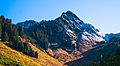
One of the northern Hidden Lake Peaks
-
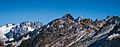
The highest of the Hidden Lake Peaks seen from the lookout with Dorado Needle (left) and Eldorado Peak (right)
-
Hidden Lake Peaks with Early Morning Spire and Dorado Needle (left)
-
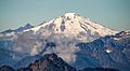
Snowking Mountain seen from Hidden Lake Peak
-
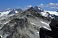
Hidden Lake Peaks, east aspect
-
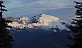
Mt. Baker seen from Hidden Lake Peaks


