History of Folkestone facts for kids
The history of Folkestone goes back a very long time, over 12,000 years! People have lived here since the Mesolithic and Paleolithic ages. Because Folkestone is so close to Europe, it has always been a busy place for people moving around. Over time, different groups like the Britons, Romans, and Saxons have lived here.
During the Iron Age, there was a big settlement called an oppidum and a workshop for making quern-stones (stones for grinding grain). Later, in Roman times, a large Roman Villa was built overlooking the sea.
In the Anglo-Saxon period, Folkestone was part of the Kingdom of Kent. After the Norman Invasion, a Norman knight owned the area. By then, Folkestone was a small fishing village. In the 1200s, it joined the Cinque Ports, which gave it special trading rights. By the Tudor period, it had become a proper town. Wars with France meant new defenses were needed, and plans for Folkestone Harbour began.
The harbor finally opened in the 1700s. Like many towns on the south coast, Folkestone became involved in smuggling. But it was the arrival of the railways in the mid-1800s that really made Folkestone grow. Tourists started to visit, and both the port and the seaside resort industries helped the town thrive.
Contents
Ancient History of Folkestone
Folkestone's history is closely linked to its natural surroundings. It sits near the North Downs Trackway, a natural path that connected the English Channel to important ancient sites like Avebury and Stonehenge. The cliffs around Folkestone are made of a special type of rock called greensand, which is unique to this area. Sadly, these cliffs have eroded a lot over thousands of years, meaning some ancient sites might have been lost to the sea. Experts believe the cliffs have worn away by about 400–500 meters since Roman times.
Early Humans: Stone Age Discoveries
Even though much has been lost to the sea, we know people lived in Folkestone as far back as 8000 BC, during the Neolithic era (New Stone Age). In 2010, archaeologists found ancient flint tools at the Folkestone Roman Villa site. These tools proved that humans were here a very long time ago. Even older tools from the Palaeolithic era (Old Stone Age) have been found nearby.
Bronze Age and Iron Age Settlements
An important Bronze Age site was found near Folkestone between 1987 and 1988, before the Channel Tunnel was built. Here, archaeologists found remains of roundhouses, fields, paths, and pottery.
During the Iron Age, a large settlement existed on the eastern headland of the bay. This site is now known as the East Wear Bay Site. Underneath the later Roman villa, there was an older Iron Age settlement that also worked as a quern-stone production center. Quern-stones were used to grind cereals into flour. People made these stones on a large scale using local greensand rock.
Over 200 quern-stones have been found at the site. Many were broken or unfinished, suggesting they were made right there. A layer of greensand dust, likely from stone-working, also supports the idea of a workshop. Folkestone querns have been found in other parts of Kent and even further away, showing that the Iron Age people of Folkestone traded widely. They received fine pottery from France and wine from Italy in return for their quern-stones.
Roman Folkestone
Before the Romans took over Britain, there was already trade between Roman Gaul (France) and the wealthy community in Folkestone. This suggests they had good relationships with the Romans. However, Roman documents don't mention Folkestone, probably because no major Roman road ended here.
In 1948, a 1st-century cemetery was found nearby, containing both British and Roman remains. Tiles with "Classis Britannica" (the Roman navy in Britain) stamps have also been found at the Roman villa site. This suggests the villa might have had a connection to the Roman navy.
The Folkestone Roman Villa
After the Romans conquered Britain, a large Roman villa was built over the older Iron Age settlement. The first version of the Folkestone Roman Villa was built around 75 AD. It was made of tufa stone with slate and ironstone foundations.
Archaeologists believe the villa might have been damaged by fire. But it was rebuilt in the 2nd century, much more luxuriously. The new villa used quarried greensand stone and had more rooms and corridors. It also featured an expanded Roman bath suite, hypocausts (underfloor heating), mosaic floors, and painted walls. The main entertainment room had great views of the courtyard and the sea. A second building was also added, with another bathing suite, kitchens, and a very large hypocaust. The villa was abandoned for unknown reasons in the 3rd or 4th century.
After the Romans: Early Medieval Times
Folkestone first appears in records in the 600s as 'Folcanstan'. This name might mean the meeting place ('–stone') of someone called Folca. Its recorded history truly begins around 630 AD. At this time, King Eadbald of Kent founded Folkestone Priory on the West Cliff for his daughter Eanswythe. She later became known as St. Eanswythe. This was likely the first Christian community for women in England.
St. Eanswythe's remains are believed to be in the parish church of St Mary and St Eanswythe. The King also built a fort nearby. Sadly, both these early structures have been destroyed by the sea or by attacks. As a result, fishermen and farmers began to settle in the valley. The town's seal shows St. Eanswythe with two fish, to remember her story.
The Middle Ages
By 1066, the church in Canterbury owned the manor of Folkestone. After William I became king, he gave the area to his half-brother, Bishop Odo. By 1086, the year of the Domesday survey, William D'Arcy held the barony. It was valued at £100 and included about 6,240 acres (25 square kilometers), 5 churches, and around 600 people.
In 1095, Nigel de Muneville, the lord of the manor, built a new church. He also started Folkestone Priory for Benedictine Monks near the old nunnery site. In 1138, William D'Averanches built another new church and priory, dedicated to St. Mary and St. Eanswythe.
In 1216, the French attacked Folkestone, destroying much of the settlement. Even though it was still a village, it was important enough to have a Mayor and a Corporation (a governing body). In 1313, Folkestone received a special charter. It became a Corporate Limb of the Cinque Port of Dover. This meant it had to provide seven boats for the king. Trade began to grow through the port, especially wool, but also luxury items like wines and cloth.
16th and 17th Centuries
During the Tudor period, there were new fears of French invasion. So, coastal defenses in Folkestone were made stronger. Gun sites were set up on the Bayle headland. By the reign of Queen Elizabeth I, Folkestone had about 120 houses. Folkestone Manor was one of the richest in Kent.
In 1545, the Town Council grew larger. Plans for a proper harbor were made in 1629, but they didn't happen at that time. Also during this period, the Free School for poor boys was founded in 1684, thanks to a gift from William Harvey. This school later became Harvey Grammar School. A Guildhall (a town meeting hall) was also built. By 1700, the town was expanding away from the beach area, up onto the hills.
In 1794, the War Office bought land west of Folkestone to build Shorncliffe. The Shorncliffe Redoubt (a type of fort) was built there. In 1796, barracks were added to house troops, many of whom were being sent to the Peninsula Wars. Later, stone buildings replaced the wooden barracks. Many thousands of soldiers have been stationed here over the years. Today, the Sir John Moore Barracks is home to the Gurkha Regiment in Britain.
18th and 19th Centuries
At the start of this period, smuggling was very common along the South Coast of England. Local people often supported smugglers, and Folkestone residents were no different. The main place for storing smuggled goods was The Warren, east of the town.
Later in the 1800s, Folkestone Harbour finally became a reality. The arrival of the railways brought a new industry to the town: tourism. This happened a bit later than in nearby towns like Margate and Ramsgate. Most of the things you'd expect at a seaside resort – like a pier, bathing areas, and theaters – only appeared after the 1880s.
Folkestone in the 20th Century

During the First World War, Folkestone welcomed about 65,000 Belgian refugees who were escaping the conflict. Shorncliffe Camp became a training ground for thousands of new soldiers. The port was the main place where soldiers left to fight in France and Belgium. Many houses, hotels, and other buildings were used for the hundreds of thousands of soldiers, including many Canadian troops. They marched through the town to the harbor along a route now called the "Road of Remembrance."
Folkestone did not suffer much serious damage in World War I. However, on May 25, 1917, a group of 21 German Gotha bombers turned back from a raid on London because of low clouds. They dropped their bombs mainly over Folkestone, killing 71 people and injuring 94 others.
After the war, many buildings needed to be fixed up for holidaymakers. New attractions were built, like the Marina and new pleasure gardens. But this period of recovery didn't last long, as much worse happened to the town in World War II.
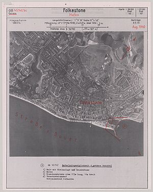
At the very beginning of World War II, thousands of schoolchildren were sent to Folkestone for safety, but they were soon moved elsewhere in 1940. Within a few weeks, Folkestone became a restricted area, and 35,000 residents left. Defenses were set up around the town, including tank traps, barbed wire, and gun batteries on the hills. During this war, the town was constantly attacked by bombs and shelling from across the Channel, and later by flying bombs. This caused huge damage, and Folkestone was changed forever.
Casualties were high: 123 people were killed, and 778 were injured. 550 houses were destroyed, and 14,441 properties were damaged. It took almost twenty years for Folkestone to become a popular holiday resort again.
In July 1967, an attempt was made to get the cargo from the Kielce, a Polish munitions ship that had sunk in 1946 off Folkestone. During the preparation work, the explosives in the ship's hold blew up. The explosion was as strong as an earthquake measuring 4.5 on the Richter scale. It created a six-meter deep crater on the seabed and caused panic in Folkestone, but thankfully, no one was injured.
 | Janet Taylor Pickett |
 | Synthia Saint James |
 | Howardena Pindell |
 | Faith Ringgold |


