Inshore coastal areas of the United Kingdom facts for kids
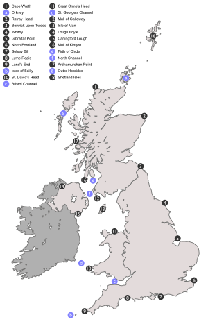
The inshore coastal areas of the United Kingdom are like special zones along the coast. There are 15 of these zones. They are used to help create weather forecasts, especially for people using small boats or those who rely on wind, like sailors. Each zone has clear boundaries, often marked by things like points of land (headlands), busy ports, or river mouths (estuaries). When you hear a weather forecast on the radio or TV, these areas are always mentioned in the same order. They go clockwise around the main island of Great Britain, starting and ending in the northwest. The Isle of Man is also part of these forecasts, even though it's not officially part of the United Kingdom.
Contents
Understanding Coastal Weather Zones
These special coastal zones help make sure that sailors, fishermen, and anyone else on the water gets the most accurate weather information for their specific location. Knowing the wind, waves, and weather conditions in these smaller areas is very important for safety.
How the Zones Are Used
Weather forecasters use these 15 areas to give detailed reports. This means a small boat near Land's End gets a forecast just for that area, which might be very different from the weather near Whitby. This detailed approach helps people plan their trips safely.
List of Inshore Coastal Areas
Here are the 15 inshore coastal areas, listed in the order they are usually given in weather forecasts:
- Cape Wrath – Rattray Head including Orkney
- Rattray Head – Berwick on Tweed
- Berwick on Tweed – Whitby
- Whitby – Gibraltar Point
- Gibraltar Point – North Foreland
- North Foreland – Selsey Bill
- Selsey Bill – Lyme Regis
- Lyme Regis – Land's End including the Isles of Scilly
- Land's End – St David's Head including the Bristol Channel
- St David’s Head – Great Orme's Head including St George's Channel
- Great Orme's Head – Mull of Galloway
- Isle of Man
- Lough Foyle – Carlingford Lough (this covers the entire coastline of Northern Ireland)
- Mull of Galloway – Mull of Kintyre including the Firth of Clyde and the North Channel
- Mull of Kintyre – Ardnamurchan Point
- Ardnamurchan Point – Cape Wrath including the Outer Hebrides
- Shetland Isles
More Detailed Forecasts
Sometimes, for even more specific information, some of these larger areas are broken down into smaller sections. For example, the BBC's coastal forecast often splits these areas at points like Duncansby Head, Harwich, or The Solent. There is also a separate forecast for the Channel Islands. This means you can get very precise weather updates for your exact location along the coast.
 | DeHart Hubbard |
 | Wilma Rudolph |
 | Jesse Owens |
 | Jackie Joyner-Kersee |
 | Major Taylor |


