Ixworth facts for kids
Quick facts for kids Ixworth |
|
|---|---|
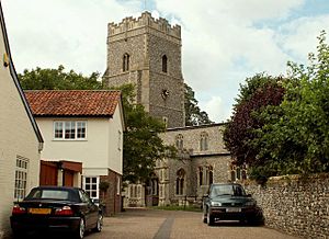
 Church of St Mary, Ixworth |
|
| Population | 2,365 (2011) |
| OS grid reference | TL934704 |
| Civil parish |
|
| District |
|
| Shire county | |
| Region | |
| Country | England |
| Sovereign state | United Kingdom |
| Post town | Bury St Edmunds |
| Postcode district | IP31 |
| Dialling code | 01359 |
| Police | Suffolk |
| Fire | Suffolk |
| Ambulance | East of England |
| EU Parliament | East of England |
Ixworth is a village in Suffolk, England. It is located about 6 kilometres (4 miles) north-east of Bury St Edmunds. The village sits on the A143 road, which connects to Diss and Thetford. In 2011, about 2,365 people lived in Ixworth.
Contents
A Look Back in Time: Ixworth's History
Roman Times in Ixworth
Ixworth was an important place for the Romans. They built a fort here in the 1st century. This fort was likely built after Boudicca's revolt, a big uprising against the Romans. The fort was used for only a short time, until the end of the 1st century. It was quite large, measuring about 193 by 205 metres (633 by 673 feet), and had three ditches around it for protection.
After the fort was no longer used, a town grew up in its place. People might have made pottery here. Ixworth became a key meeting point for Roman roads in East Anglia. The famous Peddars Way road started near Ixworth and stretched 48 miles (77 kilometres) to the coast. In 1834, parts of a Roman building were found. It had a hypocaust, which was an ancient Roman system for heating floors. This building was probably a fancy house (villa) with a bathhouse.
Anglo-Saxon Discoveries
Long after the Romans, people from the Anglo-Saxon period lived here. An old burial ground with Anglo-Saxon pots was found before 1849. Many other ancient items have been found in the area.
In 1856, a very special item was discovered: the Ixworth Cross. This was a gold pectoral cross (a cross worn on the chest) from the 7th century. It was decorated with red stones called garnets using a technique called cloisonné. This means small pieces of metal were used to make outlines, and then the spaces were filled with colourful materials. The cross was found in what is thought to be another Anglo-Saxon cemetery. It was part of a rare "bed burial," where someone was buried on a bed. Today, you can see the Ixworth Cross at the Ashmolean Museum in Oxford.
Medieval Ixworth
The earliest known name for Ixworth was "Gyxeweorde" in 1025. This name means "Enclosure of a man called Gisca." The village was mentioned again in 1040 when a man named Thurketel gave the land to Bury St Edmunds Abbey.
Ixworth was also recorded in the Domesday Book in 1086. The Domesday Book was a huge survey ordered by William the Conqueror to record all the land and property in England. In this book, Ixworth was called "Icsewrda" or "Giswortha." It was a very large village for its time, with 51 households.
Ixworth Priory was a type of monastery founded around 1170. It belonged to a group of monks called the Augustinians. The priory was closed down in 1537 during the Dissolution of the Monasteries. This was when King Henry VIII closed many monasteries across England. Today, you can still see parts of the priory, including a nearly complete eastern section. Some parts of the western section are now part of a house called Ixworth Abbey. These old buildings are very important and are listed as Grade I historical buildings.
Early Council Homes
Ixworth is famous for having the earliest rural council housing in England. Council housing means homes built by the local government for people to rent. Four pairs of houses were built here in 1893–94. This was encouraged by the Ixworth Labourer's Association. These homes were built under a new law from 1890 that allowed local councils to build their own houses. Only eight councils in the countryside used this new law. The houses are still standing today and look much like they did when they were built. Two of them, on Stow Road, are listed as Grade II historical buildings.
During World War II, a special "Q Type bombing decoy" was set up north-east of the village. This was a fake target designed to trick enemy planes into bombing an empty area instead of the real RAF Honington air base.
Ixworth Today
St Mary's Church is just west of the High Street. The church was built in the late 14th century, and its tower was added in the late 15th century. Inside, you can find memorials to important people, like Richard Coddington. He was given the land that used to belong to the priory after it was closed. The church is also a Grade I Listed Building.
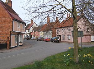
Many other buildings in Ixworth are also listed as historic, especially on the High Street. Some of these buildings have parts that are hundreds of years old. The village still has many useful services for its residents. These include shops, a post office, and places to eat (public houses). There is also a village hall, a doctor's surgery, and a fire station that shares a building with the police station.
Ixworth has bus routes that connect it to other rural areas. It is also on the National Express coach route from London to Great Yarmouth. In 1986, a bypass was built around the village. This means the main A143 now goes around Ixworth instead of through its centre.
Learning in Ixworth
Ixworth has a primary school called Ixworth Church of England Voluntary Controlled Primary School. It is for children aged 5 to 11. The school also has a nursery class for three to five-year-olds. After primary school, students can go to SET Ixworth, which teaches students aged 11 to 16. Another option is Thurston Community College, which teaches students aged 11 to 18.
Nature's Special Spot: Bangrove Wood SSSI
About 1 kilometre (0.6 miles) north of Ixworth is Bangrove Wood. This area is a Site of Special Scientific Interest (SSSI). This means it is a special protected area because of its important wildlife and natural features. Bangrove Wood is an ancient woodland, covering about 18.2 hectares (45 acres).
In the wood, you can find many different types of trees. These include ash, field maple, oak, and hazel. There are also wild cherry trees. The ground is covered with a variety of plants, making it a rich habitat for different species.
Notable Residents
- Thomas Norton
- John Griffiths
- John Lamb
- Joy Marshall
- Guy Simonds
- Bertie Stevens
- Frederick Nunn
See also
 In Spanish: Ixworth para niños
 | Georgia Louise Harris Brown |
 | Julian Abele |
 | Norma Merrick Sklarek |
 | William Sidney Pittman |


