Jackson County, Iowa facts for kids
Quick facts for kids
Jackson County
|
|
|---|---|

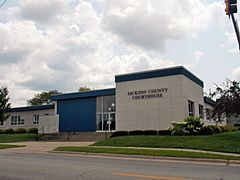
Jackson County Courthouse
|
|

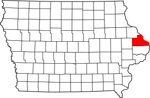
Location within the U.S. state of Iowa
|
|
 Iowa's location within the U.S. |
|
| Country | |
| State | |
| Founded | Dec 21, 1837 |
| Named for | Andrew Jackson |
| Seat | Maquoketa |
| Largest city | Maquoketa |
| Area | |
| • Total | 650 sq mi (1,700 km2) |
| • Land | 584 sq mi (1,510 km2) |
| • Water | 69 sq mi (180 km2) 10.63% |
| Population
(2020)
|
|
| • Total | 19,485 |
| • Estimate
(2023)
|
19,342 |
| • Density | 29.98/sq mi (11.57/km2) |
| Time zone | UTC−6 (Central) |
| • Summer (DST) | UTC−5 (CDT) |
| Congressional district | 1st |
Jackson County is a place in Iowa, a state in the United States. It's like a big district or area within the state. In 2020, about 19,485 people lived here. The main town, or county seat, where the county government is located, is Maquoketa.
Contents
History of Jackson County
Jackson County was officially created on December 21, 1837. It was named after Andrew Jackson, who was a President of the United States.
Geography of Jackson County
Jackson County covers a total area of about 650 square miles. Most of this area, about 636 square miles, is land. The rest, about 14 square miles, is water. The eastern edge of the county is along the Mississippi River.
Main Roads in Jackson County
These are the important highways that run through Jackson County:
Neighboring Counties
Jackson County shares its borders with several other counties:
- To the north: Dubuque County (in Iowa)
- To the northeast: Jo Daviess County (in Illinois)
- To the east: Carroll County (in Illinois)
- To the south: Clinton County (in Iowa)
- To the west: Jones County (in Iowa)
Protected Natural Areas
Jackson County has parts of special protected areas where nature is preserved:
- Driftless Area National Wildlife Refuge (part of it)
- Upper Mississippi River National Wildlife and Fish Refuge (part of it)
State Parks in Jackson County
There are also beautiful state parks for people to enjoy:
Population of Jackson County
| Historical population | |||
|---|---|---|---|
| Census | Pop. | %± | |
| 1840 | 1,411 | — | |
| 1850 | 7,210 | 411.0% | |
| 1860 | 18,493 | 156.5% | |
| 1870 | 22,619 | 22.3% | |
| 1880 | 23,771 | 5.1% | |
| 1890 | 22,771 | −4.2% | |
| 1900 | 23,615 | 3.7% | |
| 1910 | 21,258 | −10.0% | |
| 1920 | 19,931 | −6.2% | |
| 1930 | 18,481 | −7.3% | |
| 1940 | 19,181 | 3.8% | |
| 1950 | 18,622 | −2.9% | |
| 1960 | 20,754 | 11.4% | |
| 1970 | 20,839 | 0.4% | |
| 1980 | 22,503 | 8.0% | |
| 1990 | 19,950 | −11.3% | |
| 2000 | 20,296 | 1.7% | |
| 2010 | 19,848 | −2.2% | |
| 2020 | 19,485 | −1.8% | |
| 2023 (est.) | 19,342 | −2.5% | |
| U.S. Decennial Census 1790-1960 1900-1990 1990-2000 2010-2018 |
|||
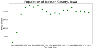
The population of Jackson County has changed over many years. The chart above shows how many people have lived here during different census counts.
2020 Census Information
In 2020, the census counted 19,485 people living in Jackson County. This means there were about 30 people per square mile. Most people (97.42%) said they belonged to one race. About 93.53% were non-Hispanic White.
2010 Census Information
The 2010 census found that 19,848 people lived in the county. There were 9,415 housing units, and 8,289 of them were lived in.
Communities in Jackson County
Jackson County has several towns and smaller communities.
Cities in Jackson County
Unincorporated Communities
These are smaller places that are not officially organized as cities:
Ghost Towns
Jackson County also has many ghost towns. These are places where people used to live, but now they are empty or have very few residents. Some examples include Alma, America, and Bridgeport.
Townships in Jackson County
Jackson County is divided into 18 smaller areas called townships. These help organize the county's land and services:
- Bellevue
- Brandon
- Butler
- Fairfield
- Farmers Creek
- Iowa
- Jackson
- Maquoketa
- Monmouth
- Otter Creek
- Perry
- Prairie Springs
- Richland
- South Fork
- Tete Des Morts
- Union
- Van Buren
- Washington
Cities by Population Size
This table shows the cities and towns in Jackson County, ranked by how many people lived there in 2010. The county seat is marked with a dagger (†).
| Rank | City/Town/etc. | Type | Population (2010 Census) |
|---|---|---|---|
| 1 | † Maquoketa | City | 6,141 |
| 2 | Bellevue | City | 2,191 |
| 3 | Preston | City | 1,012 |
| 4 | Sabula | City | 576 |
| 5 | Miles | City | 445 |
| 6 | Andrew | City | 434 |
| 7 | La Motte | City | 260 |
| 8 | Monmouth | City | 153 |
| 9 | Springbrook | City | 144 |
| 10 | St. Donatus | City | 135 |
| 11 | Baldwin | City | 109 |
| 12 | Zwingle (partially in Dubuque County) | City | 91 |
| 13 | Spragueville | City | 81 |
See also
 In Spanish: Condado de Jackson (Iowa) para niños
 | DeHart Hubbard |
 | Wilma Rudolph |
 | Jesse Owens |
 | Jackie Joyner-Kersee |
 | Major Taylor |


