
Jones County, Iowa facts for kids
Quick facts for kids
Jones County
|
|
|---|---|

|
|

Location within the U.S. state of Iowa
|
|
 Iowa's location within the U.S. |
|
| Country | |
| State | |
| Founded | December 21, 1837 |
| Named for | George Wallace Jones |
| Seat | Anamosa |
| Largest city | Anamosa |
| Area | |
| • Total | 577 sq mi (1,490 km2) |
| • Land | 576 sq mi (1,490 km2) |
| • Water | 1.4 sq mi (4 km2) 0.2% |
| Population
(2020)
|
|
| • Total | 20,646 |
| • Density | 35.78/sq mi (13.815/km2) |
| Time zone | UTC−6 (Central) |
| • Summer (DST) | UTC−5 (CDT) |
| Congressional district | 1st |
Jones County is a special area in the state of Iowa, USA. It's called a county. In 2020, about 20,646 people lived here. The main town, or county seat, where the county government is located, is Anamosa.
Jones County was started in 1837. It was named after George Wallace Jones, who was an important person in the government. He was a United States senator and also a member of Congress. Jones County is also part of the larger Cedar Rapids area. This is a "Metropolitan Statistical Area," which means it's a big city area with many towns and cities around it that are connected.
Contents
Exploring Jones County's Geography

Jones County covers a total area of about 577 square miles. Most of this is land, about 576 square miles. Only a small part, about 1.4 square miles, is water.
Main Roads and Highways
These are the important roads that go through Jones County:
 U.S. Highway 151
 Iowa Highway 1
 Iowa Highway 38
 Iowa Highway 64
 Iowa Highway 136
Local Airport
The Monticello Regional Airport (MXO) helps people travel to and from Jones County. It also serves the towns nearby.
Neighboring Counties
Jones County shares its borders with these other counties:
- Delaware County (to the northwest)
- Dubuque County (to the northeast)
- Jackson County (to the east)
- Clinton County (to the southeast)
- Cedar County (to the south)
- Linn County (to the west)
Fun Parks and Outdoor Places
Jones County has many great parks where you can explore nature and have fun!
- Wapsipinicon State Park - This park is near Anamosa. It's a big park, about 400 acres. You can go hiking, climbing, and study nature here. You can also fish in the Wapsipinicon River. The park has places for camping, picnicking, and even a golf course. There are many plants and trees, and you might see lots of flowers and wildlife. You can drive around the park and see great views of the river and bluffs. There are also cool caves like Horse Thief Cave and Ice Cave. The Wapsi River is known for its catfish, crappies, and bullheads. Sometimes you can find bass, walleye, and northern pike too. The park has 30 campsites, and 15 of them have electricity. You can find running water and hot showers for modern camping. You can also go mushroom hunting here.
- Central Park - This park is 217 acres and is located southeast of Amber. It's a popular spot for camping, and it has a 25-acre lake. You can find different types of campsites, from simple ones to those with full hook-ups. Central Park also has a swimming beach, a sand volleyball area, horseshoe pits, and a playground. There's a boat ramp for boats, hiking trails, and places you can rent for picnics. There's even a fishing pier that's easy for everyone to use. You can also rent cabins here. The Central Park Nature Center is open on Saturdays and Sundays during the summer.
- Pictured Rocks County Park - This park is south of Monticello. It's a great place for hiking and climbing. You can also get to the Maquoketa River from here. The park has picnic shelters, restrooms, playground equipment, and a boat ramp.
- Whitewater Canyon - This beautiful area has 562 acres of forests, restored grasslands, and river areas. You can go hunting and fishing here. There are also mowed hiking trails that you can use all year round. This area is east of Cascade.
- Mon-Maq Dam - This spot is northeast of Monticello along the Maquoketa River. It's 63 acres of river habitat. Many people come here for fishing. There are sandy areas downstream from the dam where canoeists and kayakers can start their trips.
Population in Jones County
| Historical population | |||
|---|---|---|---|
| Census | Pop. | %± | |
| 1850 | 3,007 | — | |
| 1860 | 13,306 | 342.5% | |
| 1870 | 19,731 | 48.3% | |
| 1880 | 21,052 | 6.7% | |
| 1890 | 20,233 | −3.9% | |
| 1900 | 21,954 | 8.5% | |
| 1910 | 19,050 | −13.2% | |
| 1920 | 18,607 | −2.3% | |
| 1930 | 19,206 | 3.2% | |
| 1940 | 19,950 | 3.9% | |
| 1950 | 19,401 | −2.8% | |
| 1960 | 20,693 | 6.7% | |
| 1970 | 19,868 | −4.0% | |
| 1980 | 20,401 | 2.7% | |
| 1990 | 19,444 | −4.7% | |
| 2000 | 20,221 | 4.0% | |
| 2010 | 20,638 | 2.1% | |
| 2020 | 20,646 | 0.0% | |
| 2023 (est.) | 20,900 | 1.3% | |
| U.S. Decennial Census 1790-1960 1900-1990 1990-2000 2010-2018 |
|||

Every ten years, the United States counts its population. This is called the census.
2020 Census Information
In 2020, the census counted 20,646 people living in Jones County. This means there were about 36 people for every square mile. Most people (96.76%) said they were of one race. About 90.80% were non-Hispanic White. Other groups included 2.14% Black, 2.41% Hispanic, 0.26% Native American, and 0.29% Asian. A small number (0.01%) were Native Hawaiian or Pacific Islander. About 4.10% were of some other race or more than one race. There were 8,871 homes in the county, and 8,113 of them were lived in.
2010 Census Information
The 2010 census found that 20,638 people lived in Jones County. The population density was very similar to 2020. There were 8,911 homes, and 8,151 of them were lived in.
Towns and Communities
Jones County has several towns and smaller communities.
Cities
Special Census Places
These are areas that are counted in the census but are not officially cities:
Other Small Communities
These are other small places in the county that are not officially cities or census-designated places:
- Canton (partially)
- Fairview
- Langworthy
- Oxford Mills
Townships
Counties are often divided into smaller areas called townships. Here are the townships in Jones County:
- Cass
- Castle Grove
- Clay
- Fairview
- Greenfield
- Hale
- Jackson
- Lovell
- Madison
- Monticello
- Oxford
- Richland
- Rome
- Scotch Grove
- Washington
- Wayne
- Wyoming
Images for kids
-
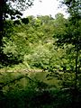
A view of Pictured Rocks County Park.
-
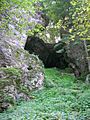
Another scenic view from Pictured Rocks County Park.
-
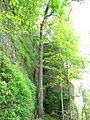
Rock formations at Pictured Rocks County Park.
-
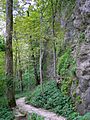
A path through Pictured Rocks County Park.


See also
 In Spanish: Condado de Jones (Iowa) para niños
