Juan de Nova Island facts for kids
Quick facts for kids
Juan de Nova Island
Île Juan de Nova (French)
|
|
|---|---|
|
Flag
|
|
|
Motto: Liberté, égalité, fraternité
|
|
|
Anthem: "La Marseillaise"
|
 |
|
 |
|
| Etymology | João da Nova |
|---|---|
| Geography | |
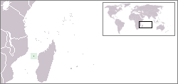
| Location | Mozambique Channel |
| Coordinates | 17°03′20″S 42°43′30″E / 17.05556°S 42.72500°E |
| Area | 4.8 km2 (1.9 sq mi) |
| Length | 6 km (3.7 mi) |
| Width | 1.6 km (1 mi) |
| Coastline | 12.3 km (7.64 mi) |
| Administration | |
| Overseas territory | French Southern and Antarctic Lands |
| District | Scattered Islands in the Indian Ocean |
| Demographics | |
| Population | 15 (military, 2019) |
| Additional information | |
| Time zone | |
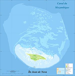
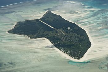
Juan de Nova Island (in French: Île Juan de Nova, in Malagasy: Nosy Kely) is a small, flat island. It is controlled by France and sits in the Mozambique Channel. This channel is a narrow sea between Madagascar and Mozambique. The island is about one-third of the way from Madagascar to Mozambique. It covers an area of 4.8 square kilometres (1.9 sq mi).
You can anchor ships off the northeast side of the island. There is also an airstrip that is 1,300-metre (4,300 ft) long. Juan de Nova is part of the Scattered Islands in the Indian Ocean. These islands are a district of the French Southern and Antarctic Lands. French soldiers from Réunion are stationed on the island. It also has a weather station that helps predict the weather.
Contents
Exploring Juan de Nova Island
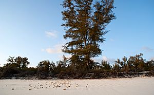
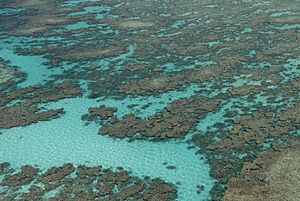
Juan de Nova is about six kilometres (3.7 mi) long and 1.6 kilometres (1 mi) wide at its widest point. It is a special nature reserve. The island is surrounded by coral reefs. These reefs create an area of about 40 square kilometres (15 sq mi) around the island. Forests, mostly of Casuarinaceae trees, cover about half of the island. Sea turtles come to the beaches around the island to lay their eggs.
Where is Juan de Nova?
Juan de Nova is located in the Mozambique Channel. It is closer to Madagascar. It is about 140 kilometres (87 mi) from Tambohorano in Madagascar. It is also 207 kilometres (129 mi) west-southwest from Tanjona Vilanandro. The island is 288 kilometres (179 mi) from the coast of Africa.
The island formed from an underwater coral reef. Ocean currents broke down the reef, creating a sandy island. Strong winds from the south-southwest create sand dunes on the island. These dunes are the highest points, reaching about 10 meters (33 ft) tall.
The southwest coast has a coral reef that makes it hard for ships to land. The northeast coast has a lagoon that becomes sandy at low tide. There is only one way for ships to get to the island. Because it's hard to access, many ships have crashed here. One famous wreck is the Tottenham. It ran aground in 1911 on the southwest coast.
The island is about 6 kilometres (3.7 mi) long from east to west. It is about 1.6 kilometres (0.99 mi) wide. Its total area is around 4.8 km² (1.9 sq mi). The entire area, including the reefs, is about 30 kilometres (19 mi) around. France claims an exclusive economic zone of 61,050 km² (23,572 sq mi) around the island.
History of Juan de Nova
Island Discovery in 1501
In 1501, a Portuguese admiral named João da Nova discovered this uninhabited island. He was from Galicia, Spain, and was sailing through the Mozambique Channel. He first called it Galega, meaning "the Galician." Later, the island was named after him, using the Spanish spelling Juan de Nova.
The island was located along the important spice route. However, it was too small to be a useful stop for ships. It might have been a hiding place for pirates, like Olivier Levasseur.
France Takes Control (1896–1975)
Juan de Nova had no permanent residents when France took control in 1897. This happened at the same time France claimed Europa Island and Bassas da India. Before this, only Malagasy fishermen visited the island during sea turtle nesting season.
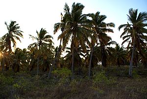
Around 1900, France leased the island to a Frenchman. He started mining guano, which is bird droppings used as fertilizer. In 1923, they produced 53,000 tons of guano. A coconut farm on the island also made 12 tons of copra (dried coconut meat) each year.
In 1921, France changed how Juan de Nova was managed. It moved the island's administration from Paris to Tananarive, the capital of its colony of Madagascar. Later, before Madagascar became independent, France moved the administration to Saint-Pierre on Réunion island. Madagascar became independent in 1960. Since 1972, Madagascar has claimed that Juan de Nova belongs to them.
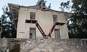
An airstrip was built on the island in 1934. Guano mining continued for many years, stopping only during World War II. The island was empty during the war and even visited by German submarines. Today, the old buildings, like a hangar, rail lines, and houses, are in ruins.
In 1952, a company called SOFIM took over the guano mining. Hector Patureau led this company. They built many structures to support the phosphate mining. These included warehouses and housing for workers.
Workers on the island mainly came from Mauritius and the Seychelles. Working conditions were very tough. In 1968, workers from Mauritius protested. This brought attention to the difficult conditions on the island.
In the 1960s, the price of phosphate dropped. Mining on the island was no longer profitable. SOFIM closed down in 1968. The last workers left the island in 1975. The French government then took back control of the island.
Weather Station and Military Presence
In 1963, a small weather station was set up to record temperature and pressure. In 1971, a representative from the Weather Service found problems with the readings. They also noted that the island was not very secure. Following international recommendations, a full-time weather station was built in 1973. It is located in the southwest part of the island, near the airstrip.
In 1974, the French government decided to place soldiers on the Scattered Islands in the Indian Ocean. This included Juan de Nova, Europa Island, and the Glorioso Islands. This was mainly to respond to Madagascar's claims over these islands. France considers these islands protected within its exclusive economic zone.
Juan de Nova Island received a small group of 14 soldiers and a police officer. They moved into buildings that used to house the mining workers. Supplies are flown to the troops every 45 days.
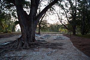
Today, most of the old mining buildings are in ruins. Only a few buildings are kept up for military use. The cemetery is also maintained. The island is now a nature preserve. Its goal is to protect the diverse plants and animals, especially the coral reefs. The island is usually closed to visitors. Scientists can get special permission for short research trips.
Shipwrecks Around the Island
Juan de Nova Island is on a shipping route between South Africa and northern Madagascar. Strong ocean currents in the area have caused many ships to crash. The most visible wreck is the SS Tottenham. It ran onto the southern reef in 1911.
Island Resources
Guano Mining
Juan de Nova Island has a large population of birds. This led to a big deposit of guano (bird droppings) on the island's surface. This was the first natural resource mined on the island in the 20th century. This mining led to the first buildings being constructed on the island. Workers also planted coconut trees, and their products were exported. Guano mining stopped around 1970 when the price of phosphates dropped.
Hydrocarbon Exploration
In 2005, the French government allowed companies to explore for oil and gas (hydrocarbons) offshore. This area covers about 62,000 square kilometers around the island. In 2008, permits were given to several companies to explore specific areas. These companies promised to invest around $100 million over five years for mining and research. The eastern edge of these exploration areas is disputed by Madagascar.
In 2015, the drilling permission was renewed for Sapetro and Marex Petroleum for three years. However, these projects were stopped in 2019. This is because the island was then classified as a nature reserve.
Animals and Plants of Juan de Nova
Scientists visit Juan de Nova Island a few times a year to study its environment. Even with ongoing research, we are just beginning to understand all the different plants and animals here. There is still much to learn.
Researchers have studied seabirds around the island. They have observed about 2 million pairs of terns that live on the island. This is the largest colony of terns in the Indian Ocean.
Pascale Chabanet, a researcher, says that the reefs around these isolated islands are very clean. They are not affected by pollution from humans. However, they are still affected by climate change. These natural environments help scientists understand how much environmental changes are caused by humans.
Scientists are also watching and trying to control invasive species on the island. These include different types of mosquitoes. One invasive Asian mosquito, Aedes albopictus, can carry diseases.
Important Bird Area
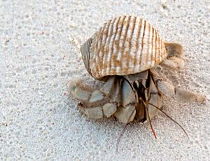
BirdLife International has named Juan de Nova Island an Important Bird Area. This is because it is home to a very large colony of sooty terns. Up to 100,000 pairs of these birds breed here. There is also a smaller group of greater crested terns. Most of the land birds on the island were probably brought there by humans.
Island Climate
Juan de Nova Island has a tropical savanna climate. A year on the island has two main seasons: a cool season and a rainy season.
| Period | Temperature | Precipitation | Humidity | |
|---|---|---|---|---|
| Cool season | April to November | 28.4 °C (April) to 25 °C (August) | 1.9 mm to 39.6 mm | 79% to 66% |
| Rainy season | December to March | Stable: 28.4 °C - 28.5 °C | 100.7 mm to 275.8 mm | 80% (December) to 83% (February) |
| Climate data for Juan de Nova Island | |||||||||||||
|---|---|---|---|---|---|---|---|---|---|---|---|---|---|
| Month | Jan | Feb | Mar | Apr | May | Jun | Jul | Aug | Sep | Oct | Nov | Dec | Year |
| Record high °C (°F) | 34 (93) |
33 (91) |
33 (91) |
33 (91) |
33 (91) |
33 (91) |
32 (90) |
33 (91) |
33 (91) |
32 (90) |
34 (93) |
35 (95) |
35 (95) |
| Mean daily maximum °C (°F) | 30.1 (86.2) |
30.0 (86.0) |
30.4 (86.7) |
30.2 (86.4) |
28.9 (84.0) |
27.4 (81.3) |
26.8 (80.2) |
26.9 (80.4) |
27.7 (81.9) |
28.8 (83.8) |
29.9 (85.8) |
30.4 (86.7) |
28.9 (84.0) |
| Daily mean °C (°F) | 28.3 (82.9) |
28.2 (82.8) |
28.6 (83.5) |
28.3 (82.9) |
27.2 (81.0) |
25.7 (78.3) |
24.9 (76.8) |
25.0 (77.0) |
25.6 (78.1) |
26.7 (80.1) |
27.8 (82.0) |
28.4 (83.1) |
27.1 (80.8) |
| Mean daily minimum °C (°F) | 26.6 (79.9) |
26.5 (79.7) |
26.8 (80.2) |
26.8 (80.2) |
25.8 (78.4) |
24.3 (75.7) |
23.4 (74.1) |
23.3 (73.9) |
23.7 (74.7) |
24.7 (76.5) |
25.8 (78.4) |
26.4 (79.5) |
25.3 (77.5) |
| Record low °C (°F) | 20 (68) |
16 (61) |
20 (68) |
21 (70) |
20 (68) |
19 (66) |
18 (64) |
17 (63) |
19 (66) |
19 (66) |
19 (66) |
22 (72) |
16 (61) |
| Average precipitation mm (inches) | 324 (12.8) |
289 (11.4) |
140 (5.5) |
21 (0.8) |
18 (0.7) |
9 (0.4) |
11 (0.4) |
4 (0.2) |
1 (0.0) |
8 (0.3) |
22 (0.9) |
139 (5.5) |
986 (38.8) |
| Average precipitation days (≥ 0.1 mm) | 13 | 13 | 9 | 5 | 3 | 3 | 2 | 1 | 1 | 2 | 3 | 10 | 65 |
| Average relative humidity (%) | 80 | 81 | 78 | 74 | 71 | 70 | 71 | 72 | 74 | 75 | 75 | 77 | 75 |
| Mean monthly sunshine hours | 229.4 | 203.4 | 257.3 | 276.0 | 282.1 | 273.0 | 275.9 | 285.2 | 282.0 | 313.1 | 300.0 | 251.1 | 3,228.5 |
| Mean daily sunshine hours | 7.4 | 7.2 | 8.3 | 9.2 | 9.1 | 9.1 | 8.9 | 9.2 | 9.4 | 10.1 | 10.0 | 8.1 | 8.8 |
| Source: Deutscher Wetterdienst | |||||||||||||
See also
 In Spanish: Isla Juan de Nova para niños
 | James Van Der Zee |
 | Alma Thomas |
 | Ellis Wilson |
 | Margaret Taylor-Burroughs |


