
Kakepuku facts for kids
Quick facts for kids Kakepuku |
|
|---|---|

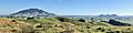
Kakepuku from the south as seen from the North Island Main Trunk Railway (Dec 2011)
|
|
| Highest point | |
| Elevation | 449 m (1,473 ft) |
| Naming | |
| English translation | ascending belly of Kahurere (flying cloak or hawk) |
| Geography | |
| Location | North Island, New Zealand |
| Topo map | BE33 Pirongia http://www.topomap.co.nz/NZTopoMap/nz53324 |
| Geology | |
| Age of rock | Pliocene |
| Mountain type | Volcano (extinct) |
| Climbing | |
| Easiest route | from Kakepuku Rd |
Kakepuku (also known as Kakipuku-o-kahurere) is a mountain that stands tall between the Waipa and Puniu rivers. It's located about 3 km northwest of Te Kawa and 8 km southwest of Te Awamutu. You can find it in the Waikato region of New Zealand's North Island.
Contents
What is Kakepuku?

Kakepuku is an extinct volcano, meaning it won't erupt again. It's part of a group of volcanoes called the Alexandra Volcanic Group. This group includes other mountains like Karioi and Pirongia.
These volcanoes were formed millions of years ago, during a time called the Pliocene period. They were created when hot, melted rock (called magma) from deep inside the Earth pushed its way up to the surface. Kakepuku itself is mostly made of a type of rock called basalt lava. It was formed around 2.5 million years ago.
History and Legends
Kakepuku was given its name by Rakataura, a wise Tainui leader. One story says he named it after the shape of his pregnant wife, Kahurere.
There's also a famous Māori legend about Kakepuku. The story says that Kakepuku was a mountain that traveled north looking for his father. When he reached the Waipa plain, he fell in love with Te Kawa, who was the daughter of Pirongia and Taupiri Mountains.
However, another mountain named Karewa also liked Te Kawa. The mountains fought, and Karewa lost. Kakepuku chased Karewa, throwing rocks at him, until Karewa fled into the Tasman Sea. Today, Karewa is known as Gannet Island. So, Kakepuku still stands proudly, watching over Te Kawa.
People from the Tainui tribe started living in the Kakepuku area around 1550 AD. There were likely other groups living there even earlier. The area is part of the traditional lands of the Ngāti Maniapoto people. You can still find four old fortified villages, called pa sites, hidden in the forest on the mountain.
Walking to the Summit
If you want to explore Kakepuku, there's a walking track that goes all the way to the top! It starts from the car park and follows an old farm road, so it's not too steep. The lower part of this track can also be used by mountain bikers.
Once you get near the top, the track continues along a ridge. You'll walk through a beautiful part of the original forest inside an ancient volcano crater. Finally, you'll reach the summit, which is 449 meters high. There's a trig station (a survey marker) at the very top.
Protecting Nature
The Kakepuku Mountain Conservation Project is a special effort to protect the mountain's natural environment. It covers a large area, including the Kakepuku Mountain Historic Reserve and nearby lands.
This project started in 1995 because people were worried about the health of the native forest on Kakepuku. The main goal is to reduce the number of pests like possums, rats, and goats. This helps the native trees and birds to thrive.
Thanks to the project, 30 North Island robins were brought back to the mountain in 1999. Later, the New Zealand falcon was also reintroduced. Areas on the edge of the mountain that had weeds were replanted with native plants. Now, you can often see native birds like tui and kereru flying around.
The reserve is home to many native trees, including tawa, rewarewa, kohekohe, mangeao, and pukatea.
Gallery
-
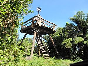
Kakepuku summit lookout tower - Pirongia, Maungatautari, Lake Ngaroto and Mount Tarawera are among the places visible from the top
-
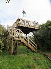
The lookout was rebuilt in 2014. It had been closed for a while due to rot
-
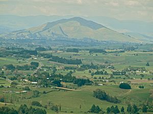
Kakepuku from the north as seen from the Karamu Walkway
-
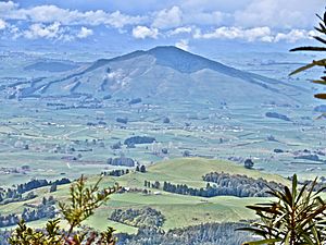
Kakepuku (449m) from the west, as seen from Wharauroa (850m), Mount Pirongia


Images for kids
-
Kakepuku and Te Kawa from Ouruwhero Rd (south)
