Kent County, Rhode Island facts for kids
Quick facts for kids
Kent County
|
|
|---|---|

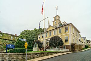
The East Greenwich Town Hall historically served as the Kent County Courthouse
|
|
| Country | |
| State | |
| Region | New England |
| Metro area | Providence |
| Formed | June 11, 1750 |
| Named for | Kent, England |
| County town | East Greenwich |
| Largest city | Warwick |
| Incorporated municipalities |
5 (total)
1 city, 4 towns
|
| Area | |
| • Total | 188 sq mi (490 km2) |
| • Land | 169 sq mi (440 km2) |
| • Water | 20 sq mi (50 km2) 10%% |
| Highest elevation | 629 ft (192 m) |
| Lowest elevation | 0 ft (0 m) |
| Population | |
| • Total | 170,363 |
| • Density | 910/sq mi (350/km2) |
| GDP | |
| • Total | $11.417 billion (2022) |
| Time zone | UTC−5 (EST) |
| • Summer (DST) | UTC−4 (EDT) |
| ZIP Code format |
028xx
|
| Area code | 401 |
| FIPS code | 44-003 |
| GNIS feature ID | 1219778 |
| Congressional district | 2nd |
Kent County is a special area located in the state of Rhode Island, United States. It's called a county, but in Rhode Island, counties don't have their own governments like in many other states. Instead, they mostly help organize things like courts and sheriff services.
As of 2020, about 170,363 people live here, making it the second-most populated county in Rhode Island. Kent County was created in 1750 from a part of Providence County. It was named after the county of Kent in England. The main town for county services is East Greenwich. Kent County is also part of the larger Providence-Warwick area, which connects to even bigger cities like Boston.
Contents
Exploring Kent County's Land and Location
Kent County covers a total area of about 188 square miles. Most of this area, about 169 square miles, is land. The rest, about 20 square miles (or 10%), is water.
Neighboring Areas: Counties Around Kent
Kent County shares its borders with several other counties:
- Providence County to the north
- Bristol County to the east
- Washington County to the south
- New London County, Connecticut to the southwest
- Windham County, Connecticut to the west
- Newport County to the southeast
Main Roads and Highways in Kent County
Many important roads run through Kent County, helping people travel around. These include major highways and state routes:
 I-95
I-95 I-295
I-295 US 1
US 1 US 1A
US 1A Route 2
 Route 3
 Route 4
 Route 5
 Route 14
 Route 33
 Route 37
 Route 51
 Route 102
 Route 113
 Route 115
 Route 116
 Route 117
 Route 117A
 Route 118
 Route 401
 Route 402
 Route 403
Who Lives in Kent County? Population Facts
Every ten years, the U.S. government counts everyone living in the country. This helps us understand how many people live in places like Kent County and what their communities are like.
Population Snapshot: 2010 Census Details
In 2010, the census counted 166,158 people living in Kent County. On average, there were about 986 people per square mile. There were also 68,645 households, which are groups of people living together in one home.
Most people in Kent County (93.4%) identified as white. Other groups included 2.0% Asian, 1.4% black or African American, and 0.3% American Indian. About 3.2% of the population was of Hispanic or Latino background.
Many people in Kent County have family roots from different parts of the world. The largest groups of people by ancestry included:
 26.7% Irish
 23.2% Italian
 17.3% English
 16.3% French
 8.9% Portuguese
 7.6% German
 4.8% Polish
 4.4% French Canadian
 3.3% American
 2.9% Swedish
 2.4% Scottish
 1.7% Scotch-Irish
 1.4% Russian
About 28.7% of households had children under 18 living with them. The average age of people in Kent County was 42.7 years old.
The average yearly income for a household was about $61,088. For families, it was around $77,100. About 7.9% of all people in the county lived below the poverty line, including 9.5% of those under 18.
Cities, Towns, and Villages in Kent County
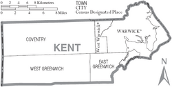
Kent County is made up of one city and several towns and villages.
The City of Kent County
Towns in Kent County
- Coventry
- East Greenwich (This is the traditional main town for county services)
- West Greenwich
- West Warwick
Census-Designated Place (CDP)
A Census-Designated Place is an area that looks like a town but isn't officially incorporated as one.
Other Villages and Communities
These are smaller communities within the towns of Kent County.
- Anthony
- Arkwright
- Blackrock
- Coventry Centre
- Crompton
- Fairbanks
- Harris
- Hillsgrove
- Hopkins Hollow
- Nooseneck
- Lippitt
- Quidnick
- Spring Lake
- Summit
- Tiogue
- Washington
- Whaley's Hollow
See also
 In Spanish: Condado de Kent (Rhode Island) para niños


