La Salle County, Texas facts for kids
Quick facts for kids
La Salle County
|
|
|---|---|

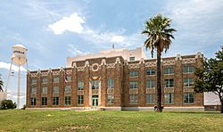
The La Salle County Courthouse in Cotulla has undergone extensive renovation (2018).
|
|

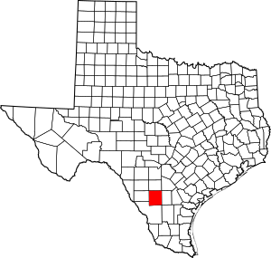
Location within the U.S. state of Texas
|
|
 Texas's location within the U.S. |
|
| Country | |
| State | |
| Founded | 1880 |
| Named for | René-Robert Cavelier, Sieur de La Salle |
| Seat | Cotulla |
| Largest city | Cotulla |
| Area | |
| • Total | 1,494 sq mi (3,870 km2) |
| • Land | 1,487 sq mi (3,850 km2) |
| • Water | 7.5 sq mi (19 km2) 0.5%% |
| Population
(2020)
|
|
| • Total | 6,664 |
| • Density | 4.5/sq mi (1.7/km2) |
| Time zone | UTC−6 (Central) |
| • Summer (DST) | UTC−5 (CDT) |
| Congressional district | 23rd |
La Salle County is a county located in the state of Texas. In 2020, about 6,664 people lived there. The main town and county seat is Cotulla.
The county was first created in 1858. It was officially organized in 1880. La Salle County is named after René-Robert Cavelier, Sieur de La Salle. He was a French explorer from the 1600s.
History
Early Days
The land that is now La Salle County was once home to the Coahuiltecan Native Americans. This was until the 1700s. Then, Spanish settlers from the south and Apache tribes from the north moved into the area.
After Mexico became independent from Spain, the Mexican government offered land grants. This was to encourage people to settle here. However, very few people moved to this area. By 1836, only Native Americans lived in the region.
Disputed Lands
After the Texas Revolution, the area became a disputed zone. It was located between the Rio Grande and the Nueces River. Neither the Mexican government nor the Republic of Texas fully controlled it. This made the area quite wild.
In 1848, the Treaty of Guadalupe Hidalgo gave this land to Texas. But outlaws and Native American tribes made it hard for new settlers to arrive.
County Formation and First Settlements
La Salle County was officially formed in 1858. It was created from the large Bexar District. The first small towns grew along the road from Laredo to San Antonio.
In 1852, the U.S. Army built Fort Ewell. This fort was near where Artesia Wells is today. It helped protect travelers on the road. The fort was closed in 1854. The people who lived there moved to a nearby settlement called Guajoco. By 1871, about 60 people lived in Guajoco. Most of them were of Mexican heritage.
Ranches and New Towns
In 1856, William A. Waugh started a ranch. It was where the San Antonio–Laredo road crossed Cibolo Creek. His ranch became a popular stop for travelers. In 1879, a post office opened there, called Waugh's Rancho.
Another early settlement was Iuka. It was founded in 1868 by several families. Iuka was a stagecoach stop and a place for cattle buyers. It got a post office in 1880. In 1870, La Salle County had only 69 people. By 1880, the population grew to 789.
Railroads Arrive
La Salle County was formally organized in 1880. Stuart's Rancho was chosen as the county seat. In the early 1880s, the International-Great Northern Railroad built tracks through the county. This helped bring more order and safety to the area. The last Native American raid happened in 1878.
When the railroad arrived, many people moved closer to the tracks. Older settlements like Iuka and Guajoco were left behind. Joseph Cotulla, an immigrant from Poland, came to La Salle County in 1868. He built a very large ranch. In 1881, Cotulla gave 120 acres of his land to the railroad. This land was used to build the town of Cotulla. The railroad built a station there in 1882.
While Cotulla grew his town, another town called La Salle was started nearby. It was just across the tracks. La Salle got a post office in 1881. It was even named the temporary county seat in 1882. But in 1883, Cotulla became the official county seat after a special vote.
Geography
La Salle County covers about 1,494 square miles. Only a small part, about 7.5 square miles, is covered by water.
Major Highways
 I-35
I-35 Bus. I-35
 Bus. I-35
 SH 44
SH 44 SH 97
SH 97 FM 133
 FM 468
 FM 469
 FM 624
 FM 1582
Neighboring Counties
- Frio County (north)
- Atascosa County (northeast)
- McMullen County (east)
- Webb County (south)
- Dimmit County (west)
- Zavala County (northwest)
Demographics
| Historical population | |||
|---|---|---|---|
| Census | Pop. | %± | |
| 1870 | 69 | — | |
| 1880 | 789 | 1,043.5% | |
| 1890 | 2,139 | 171.1% | |
| 1900 | 2,303 | 7.7% | |
| 1910 | 4,747 | 106.1% | |
| 1920 | 4,821 | 1.6% | |
| 1930 | 8,228 | 70.7% | |
| 1940 | 8,003 | −2.7% | |
| 1950 | 7,485 | −6.5% | |
| 1960 | 5,972 | −20.2% | |
| 1970 | 5,014 | −16.0% | |
| 1980 | 5,514 | 10.0% | |
| 1990 | 5,254 | −4.7% | |
| 2000 | 5,866 | 11.6% | |
| 2010 | 6,886 | 17.4% | |
| 2020 | 6,664 | −3.2% | |
| U.S. Decennial Census 1850–2010 2010–2014 |
|||
Population Information
| Race / Ethnicity (NH = Non-Hispanic) | Pop 2000 | Pop 2010 | Pop 2020 | % 2000 | % 2010 | % 2020 |
|---|---|---|---|---|---|---|
| White alone (NH) | 1,114 | 894 | 1,467 | 18.99% | 12.98% | 22.01% |
| Black or African American alone (NH) | 192 | 18 | 221 | 3.27% | 0.26% | 3.32% |
| Native American or Alaska Native alone (NH) | 5 | 25 | 3 | 0.09% | 0.36% | 0.05% |
| Asian alone (NH) | 18 | 6 | 4 | 0.31% | 0.09% | 0.06% |
| Pacific Islander alone (NH) | 0 | 0 | 0 | 0.00% | 0.00% | 0.00% |
| Other race alone (NH) | 2 | 5 | 5 | 0.03% | 0.07% | 0.08% |
| Mixed race or Multiracial (NH) | 11 | 18 | 56 | 0.19% | 0.26% | 0.84% |
| Hispanic or Latino (any race) | 4,524 | 5,920 | 4,908 | 77.12% | 85.97% | 73.65% |
| Total | 5,866 | 6,886 | 6,664 | 100.00% | 100.00% | 100.00% |
In 2020, the county had 6,664 people living in 2,142 households. About 1,659 of these were families.
Back in 2000, there were 5,866 people. The population density was about 4 people per square mile. Most people in the county were White (81.47%), with a significant Hispanic or Latino population (77.12%).
In 2000, about 37.7% of households had children under 18. Over half (54.7%) were married couples. The average household had 2.89 people. The average family had 3.45 people.
The median age in the county was 33 years old. This means half the people were younger than 33 and half were older. About 29.4% of the population was under 18.
In 2000, the median income for a household was $21,857. For a family, it was $25,494. The income per person was $9,692. About 29.8% of the people lived below the poverty line. This included 38.5% of those under 18.
Education
Most students in La Salle County attend schools in the Cotulla Independent School District. A small part of the county is served by the Dilley Independent School District.
For college, students can attend Southwest Texas Junior College.
Communities
Cities
Census-designated place
Unincorporated communities
- Artesia Wells
- Los Angeles
- Millett
Ghost town
- Dull
Notable people
O. Henry, a famous short-story writer, lived and worked on a sheep ranch in La Salle County. He was here from 1882 to 1884.
Ray Keck, who is the president of Texas A&M International University, grew up in Cotulla. His father was a bank president there.
See also
 In Spanish: Condado de La Salle (Texas) para niños


