Lake Balkhash facts for kids
Quick facts for kids Lake Balkhash |
|
|---|---|
| Балқаш көлі, Balqaş kölı Озеро Балхаш |
|
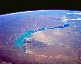
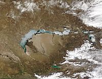
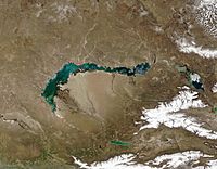
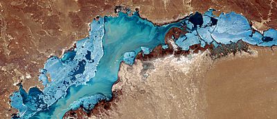
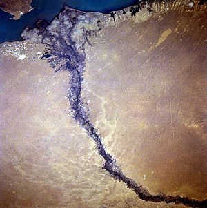
View from Space, April 1991
|
|
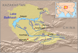
Map of the Lake Balkhash drainage basin
|
|
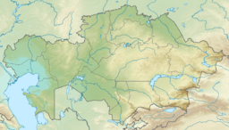
| Location | Kazakhstan |
| Coordinates | 46°10′N 74°20′E / 46.167°N 74.333°E |
| Type | Endorheic, Saline |
| Primary inflows | Ili, Karatal, Aksu, Lepsy, Byan, Kapal, Koksu rivers |
| Primary outflows | evaporation |
| Basin countries | Kazakhstan |
| Max. length | 605 km (376 mi) |
| Max. width | East 19 km (12 mi) West 74 km (46 mi) |
| Surface area | 16,400 km2 (6,300 sq mi) |
| Average depth | 5.8 m (19 ft) |
| Max. depth | 26 m (85 ft) |
| Water volume | 100 km3 (24 cu mi) |
| Surface elevation | 341.4 m (1,120 ft) |
| Frozen | November to March |
Lake Balkhash is a huge lake in southeastern Kazakhstan. It is one of the biggest lakes in Asia. In fact, it's the 15th largest lake in the whole world!
This lake is special because it's in a "closed basin." This means no rivers flow out of it. Water only enters the lake from rivers like the Ili. The Ili River gets its water from rain and melting snow in the mountains of China.
Lake Balkhash is currently about 16,400 km2 (6,300 sq mi) big. But it's actually getting smaller. This is happening because people are using a lot of water from the rivers that feed the lake.
A narrow strip of land divides the lake into two parts. The western part of the lake has fresh water. But the eastern part is salty, like the ocean! The eastern part is also deeper than the western part.
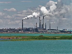
The biggest city on the lake is called Balkhash. About 66,000 people live there. The main jobs in the area are mining, processing ores (like copper), and fishing. People are worried that the lake is getting too shallow. This is due to the dry climate and too much water being taken for factories.
Contents
History of Lake Balkhash
The name "Balkhash" comes from an old word. It means "tussocks in a swamp" in languages like Tatar and Kazakh.
Long ago, from about 103 BC to the 8th century, the Chinese knew the area around the lake by different names. Later, the land south of the lake was called Jetisu. This means "Seven Rivers" in Turkic languages. It was a place where nomadic people and settled groups mixed their cultures.
During China's Qing dynasty (1636–1912), the lake was the far northwestern border of their empire. In 1864, the lake became part of the Russian Empire. This happened after a special agreement called the Treaty of Tarbagatai. When the Soviet Union broke up in 1991, Lake Balkhash became part of Kazakhstan.
How Lake Balkhash Was Formed
Lake Balkhash sits in a very deep area called the Balkhash-Alakol depression. This depression was created a long, long time ago. It formed between mountains and an older landmass. Over time, fast-moving rivers from the Tian Shan mountains filled this depression with sand and river dirt.
This area also includes other lakes like Sasykkol and Alakol. All these lakes are what's left of an ancient sea. This sea once covered the entire Balkhash-Alakol depression.
About the Lake's Features
All the rivers in this region flow into Lake Balkhash. But no rivers flow out of it. The most important rivers are the Ili, Aksu, and Karatal.
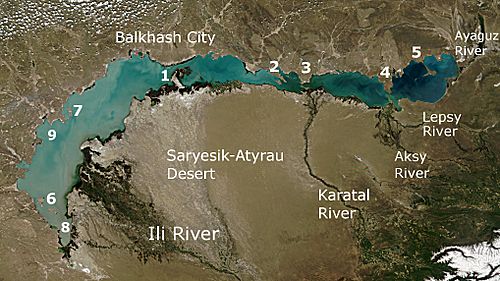
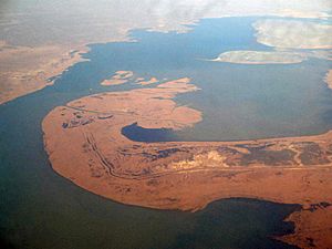
A strip of land called the Saryesik peninsula divides the lake into two parts. Saryesik means "Yellow Door" in Kazakh. These two parts are connected by a narrow channel called the Uzynaral strait.
In the past, Lake Balkhash was much bigger. Many smaller lakes nearby were once part of it. Even further back, it was a huge sea.
In 1910, the lake was about 23,464 square kilometers. By 1946, it had shrunk to 15,730 square kilometers.
Lake Size and Depth
The lake covers about 16,400 square kilometers (in 2000). This makes it the largest lake entirely within Kazakhstan. Its surface is about 340 meters above sea level.
The lake has a gentle curve, like a sickle. But its edges are very jagged. It is about 600 kilometers long. The width changes a lot. In the eastern part, it's only 9–19 kilometers wide. But in the western part, it can be up to 74 kilometers wide.
The Saryesik Peninsula divides the lake into two very different sections. The western part is 58% of the lake's area. It is quite shallow and calm, and it has fresh water. The eastern part is much deeper and saltier. These two parts are joined by the Uzynaral Strait. This strait is 3.5 kilometers wide and about 6 meters deep.
The numbers mark the largest peninsulas, island and bays:
|
The lake has several smaller deep areas. In the western part, there are two spots 7–11 meters deep. The eastern part is deeper on average, about 16 meters. Its deepest point is 26 meters.
The average depth of the whole lake is 5.8 meters. The total amount of water is about 112 cubic kilometers.
The northern and western shores of the lake are high and rocky. They are made of old rocks and show signs of ancient water levels. The southern shores are low and sandy. They often flood and have many small pools of water. The coastline is very curvy with many bays and coves.
The lake has 43 islands. Their total area is 66 square kilometers. More islands are forming as the water level drops. The existing islands are also getting bigger.
Water Levels and What Feeds the Lake
The Balkhash-Alakol Basin covers a huge area of 512,000 square kilometers. Most of the water that flows into the lake comes from this basin. About 11.5 cubic kilometers of water each year comes from China.
The Ili provides most of the water to the lake. It brings 73–80% of the total inflow. The Ili River starts in the Tian Shan mountains. It gets most of its water from melting glaciers. The water flow is usually strongest when the glaciers melt, from June to July.
The eastern part of the lake gets water from the Karatal, Aksu, and Lepsy rivers. It also gets water from underground sources. The Karatal River is the second largest source of water.
The size and amount of water in the lake change. This is due to natural ups and downs in water levels. For example, between 1958 and 1969, the lake grew to about 18,000 square kilometers. But during dry periods, like in the 1930s and 1940s, it shrank to about 16,000 square kilometers.
Since the late 1900s, the lake has been shrinking because people are taking water from the rivers that feed it. For instance, the Kapshagay Hydroelectric Power Plant was built on the Ili River in 1970. Filling the Kapshagay Reservoir caused the lake's water level to drop by 2.2 meters between 1970 and 1987. This also made the water saltier in the western part.
Total inflow to the lake was 22.51 km3, including:
Total losses amounted to 24.58 km3, including
|
The lowest water level in recent times was in 1987. This was when the Kapshagay Reservoir was completely filled. But the water level went up again by 2005. This happened because there was a lot of rain in the late 1990s.
Water Makeup
Lake Balkhash is a "semi-saline" lake. This means it's partly salty. The water in the western part is almost fresh. It has very little salt and is a bit cloudy. This water is used for drinking and by factories.
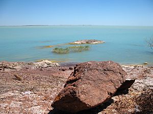
The eastern part of the lake is much saltier. It's similar to ocean water. The average saltiness of the whole lake is 2.94 grams per liter. The western water looks yellow-gray. The eastern water can be bluish or emerald-blue.
Climate Around the Lake
The area around Lake Balkhash has a continental climate. This means it has very hot summers and very cold winters. The average temperature in July is about 24 °C, but it can get up to 30 °C. In January, the average temperature is −14 °C.
The area gets about 131 millimeters of rain each year. The air is usually about 60% humid. Because it's dry and hot in summer, a lot of water evaporates from the lake. Winds blow mainly from the south and southwest. These winds can create waves up to 2–3.5 meters high.
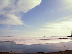
The lake gets 110–130 sunny days each year. The water temperature on the surface ranges from 0 °C in December to 28 °C in July. The lake freezes every year. It usually freezes between November and early April. The eastern part stays frozen a bit longer.
| Weather chart for Balkhash City | |||||||||||||||||||||||||||||||||||||||||||||||
|---|---|---|---|---|---|---|---|---|---|---|---|---|---|---|---|---|---|---|---|---|---|---|---|---|---|---|---|---|---|---|---|---|---|---|---|---|---|---|---|---|---|---|---|---|---|---|---|
| J | F | M | A | M | J | J | A | S | O | N | D | ||||||||||||||||||||||||||||||||||||
|
13
-9
-18
|
10
-8
-18
|
10
0
-10
|
11
14
3
|
15
22
10
|
12
28
16
|
10
30
18
|
8
28
16
|
4
22
9
|
9
13
2
|
14
3
-6
|
15
-5
-13
|
||||||||||||||||||||||||||||||||||||
| temperatures in °C precipitation totals in mm |
|||||||||||||||||||||||||||||||||||||||||||||||
|
Imperial conversion
|
|||||||||||||||||||||||||||||||||||||||||||||||
| Depth | Jan | Feb | Mar | Apr | May | June | July | Aug | Sep | Oct | Nov | Dec |
|---|---|---|---|---|---|---|---|---|---|---|---|---|
| Eastern part of the lake | ||||||||||||
| 0 | – | −0.2 | 0.2 | – | 13.9 | 19.0 | 23.4 | 23.2 | 17.2 | 11.4 | – | – |
| 10 | – | 1 | – | – | 10.8 | 16.7 | 21.7 | 22.8 | – | – | – | – |
| 20 (near the bottom) |
– | 1.7 | 1.9 | – | 8.9 | 13.7 | 14.6 | 19.7 | 17.1 | 11.5 | – | – |
| Western part of the lake, near Balkhash City | ||||||||||||
| 0 | – | 0.0 | 0.8 | 6.7 | 13.3 | 20.5 | 24.7 | 22.7 | 16.6 | 7.8 | 2.0 | – |
| 3 (near the bottom) |
– | 0.3 | 2.2 | 6.5 | 13.1 | 19.6 | 24.1 | 22.6 | 16.5 | 7.4 | 2.0 | – |
Plants and Animals of Lake Balkhash
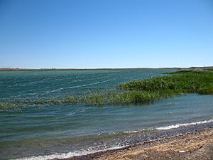
The shores of Lake Balkhash have willow trees and forests. These forests are mostly made up of different kinds of Populus trees. Other plants include common reed and several types of cane. Under the water, you can find different kinds of Myriophyllum and Potamogeton plants. Tiny plants called Phytoplankton also live in the water.
The lake used to have many different animals. But since 1970, the number of different species has gone down. This is because the water quality has gotten worse. Before that, there were lots of shellfish, crustaceans, and tiny water animals.
The lake was home to about 20 types of fish. Six of these fish types were native to the lake. These included the Ili marinka and Balkhash perch. Other fish species were brought in from other places. These included common carp and European perch. Fishing was a big industry, focusing on carp, perch, and bream.
Thick reeds in the southern part of the lake, especially in the Ili River delta, were a safe home for many birds and animals. But changes in the water level have harmed this area. Since 1970, the delta has shrunk a lot. This means less wetlands and forests for animals. Other things like farming, pesticides, and cutting down trees have also reduced the number of different animals.
Out of 342 types of animals with backbones, 22 are now endangered. These are listed in the Red Book of Kazakhstan. The forests in the Ili delta used to be home to the rare (and now probably gone) Caspian tiger. It hunted wild boars there. In the 1940s, Canadian muskrats were brought to the Ili delta. They quickly made themselves at home and were hunted for their fur. But recent changes in water level have destroyed their homes, stopping the fur industry.
Lake Balkhash is also home to 120 types of birds. These include cormorants, pheasants, and golden eagles. Twelve of these birds are endangered. Some endangered birds are the great white pelican, Eurasian spoonbill, and white-tailed eagle.
Cities and Economy Around the Lake
In 2005, about 3.3 million people lived in the area around Lake Balkhash. This includes people in Almaty, which is the biggest city in Kazakhstan. The largest city right on the lake is Balkhash, with about 66,724 people (in 2010). It's on the northern shore and has a big mining and metal processing factory.
A large amount of copper was found in the area between 1928 and 1930. This copper is now being mined in villages north of the lake. Part of the highway between Bishkek and Karaganda runs along the western side of the lake. The western shore also has military buildings from the Soviet era. The southern shore has very few people and only a few small villages.
The beautiful nature and wildlife of the lake attract tourists. There are several resorts on the lake. In 2021, Lake Balkhash was chosen as one of the top 10 places to visit in Kazakhstan.
Fishing Industry
Fishing is very important to the economy of the lake. People started raising fish in the lake in 1930. The amount of fish caught each year was 20,000 tonnes in 1952. It grew to 30,000 tonnes in the 1960s. But by the 1990s, the amount of fish caught dropped to 6,600 tonnes per year. This drop is due to several reasons. These include stopping fish breeding programs, illegal fishing, and the lower water level and quality.
Energy Projects
In 1970, the Kapshagay Hydroelectric Power Plant was built on the Ili River. This plant uses water from the new Kapshagay Reservoir to create electricity and for irrigation (watering crops). Water from the Ili River is also used a lot upstream in China for growing cotton.
There's a plan for another dam downstream from Kapchagay. This new power plant will help provide electricity to southern Kazakhstan. It will also help control the water level of the Ili River.
Providing enough energy to southeastern Kazakhstan has been a long-standing issue. In 2008, the Kazakh government decided to build a Thermal Power Plant near Balkhash.
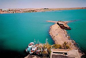
Ships regularly travel on the lake, in the mouth of the Ili River, and in the Kapchagay Reservoir. The main ports are Burylbaytal and Burlitobe. The ships are not very heavy because some parts of the lake are shallow. They are mainly used for fishing and moving fish and building materials. Ships can travel on the water for 210 days each year. The total length of the waterways is 978 kilometers.
Shipping on Lake Balkhash started in 1931 with two steamboats and three barges. By 1996, about 120,000 tonnes of building materials were transported each year. Also, 3,500 tonnes of ore, 45 tonnes of fish, and 3,500 passengers were moved. In 2004, 1,000 passengers and 43 tonnes of fish were transported.
In 2004, the local fleet had 87 vessels. This included 7 passenger ships, 14 cargo barges, and 15 tugboats. The government expects that by 2012, much more cargo and more passengers will be transported. They also hope that eco-tourism will grow, bringing more visitors to the lake.
Environmental Concerns
Experts are worried that the lake's natural environment could be seriously harmed. They fear it might become like the Aral Sea, which faced a huge environmental disaster. Since 1970, the amount of water flowing into the lake from the Ili River has dropped by 66%. This is because of the water taken to fill the Kapchagay Reservoir. The lake's water level has been dropping by about 15.6 centimeters each year.
The western part of the lake is becoming very shallow. From 1972 to 2001, a small salt lake nearby almost disappeared. The southern part of Lake Balkhash lost about 150 square kilometers of water surface. Out of 16 lake systems around Balkhash, only five are left. About one-third of the lake's basin is turning into desert. Salt dust blows from these dry areas. This causes dust storms and makes the soil saltier. It also affects the climate. More dirt building up in the river's delta also reduces the water flowing into the lake.
| Location | 1997 | 2000 | 2001 |
|---|---|---|---|
| Gulf Tarangalyk | 2.38 | 3.70 | 3.96 |
| Gulf MA Sary-Shagan | 2.56 | 4.83 | 4.52 |
Another problem for the Ili-Balkhash area is pollution from mining and metal processing. This mostly comes from the Balkhash Mining and Metallurgy Plant. In the early 1990s, this plant released 280–320 thousand tonnes of pollution each year. This included 76 tonnes of copper, 68 tonnes of zinc, and 66 tonnes of lead that landed on the lake's surface. Since then, the pollution has almost doubled. Dust storms also carry pollution from waste sites into the lake.
In 2000, a big meeting called Balkhash 2000 was held. Scientists, businesses, and government officials from different countries attended. They agreed on a plan to help manage the ecosystems of the Alakol and Balkhash basins. At another meeting in 2005, the company Kazakhmys announced that it would reduce its pollution by 80–90% by 2006.
Pollution in Balkhash doesn't just come from nearby. It also comes from polluted water flowing in from China. China also uses a lot of water from the Ili River each year. They plan to use even more water in the future. In 2007, Kazakhstan offered to sell its products to China at a lower price if China would use less water from the Ili River. But China did not accept this offer.
See also
 In Spanish: Lago Baljash para niños
- Balkhash – the city at Lake Balkhash
- Korzhin Island
 | John T. Biggers |
 | Thomas Blackshear |
 | Mark Bradford |
 | Beverly Buchanan |


