Lancaut facts for kids
Quick facts for kids Lancaut |
|
|---|---|
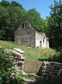
 Ruins of St James' church at Lancaut |
|
| OS grid reference | ST5396 |
| Civil parish |
|
| District |
|
| Shire county | |
| Region | |
| Country | England |
| Sovereign state | United Kingdom |
| Post town | CHEPSTOW |
| Postcode district | NP16 |
| Dialling code | 01291 |
| Police | Gloucestershire |
| Fire | Gloucestershire |
| Ambulance | Great Western |
| EU Parliament | South West England |
| UK Parliament |
|
Lancaut (which in Welsh is called Llan Cewydd) is a deserted village in Gloucestershire, England. It's located next to the River Wye, about two miles north of Chepstow. This area was once its own small parish, but now it's part of Tidenham.
Lancaut sits on a narrow piece of land shaped by a bend in the River Wye. The river here forms the border between England and Wales. Today, not much is left of the old village. The most important ruin is the roofless church of St. James.
Contents
A Look Back: Lancaut's History
The land where Lancaut is located is naturally easy to defend. You can still see the old walls of an Iron Age fort called Spital Meend. This fort was built across the narrowest part of the land. From the fort, people could see up and down the Wye River. They could also see east towards the Severn estuary.
The name Lancaut comes from the Welsh words Llan Cewydd. This means 'Church of Saint Cewydd'. Saint Cewydd was a Welsh saint from the 500s.
In the late 700s, a large ditch and bank called Offa's Dyke was built. This was to mark the border of the Anglo-Saxon kingdom of Mercia. It also helped stop attacks from the Welsh people in the west. Offa's Dyke passed to the east of Lancaut. It even used part of the old Spital Meend fort's defenses.
Even though Lancaut was on the English side of the river, it stayed under Welsh control for a while. By the year 956, it became part of the English king's land in Tidenham.
Lancaut was never a big village. In 1306, there were 10 families living there. By 1551, about 19 adults lived in the village.
During the English Civil War in 1645, a Royalist leader named Sir John Wintour tried to take control of a shallow river crossing (called a ford) at Lancaut. He was defeated and had to escape by boat. This led to a local story that he jumped off the cliffs below Lancaut with his horse to get away. These cliffs are now known as Wintour's Leap.
By 1750, only two houses were still lived in at Lancaut. In 1848, only 16 people lived in the parish. By 1931, the population was just 10. The small parish of Lancaut officially joined Tidenham on April 1, 1935. Today, the only thing left of the village is a farm that is still working.
St James' Church: A Historic Ruin
The most important building left at Lancaut is St James' Church. It is a very old building that is protected as a Grade II listed building. This means it's an important historic site.
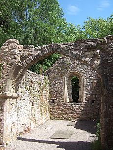
Records from the 600s mention a religious place called lann ceuid here. A monastery was also recorded here by the year 703. However, the church building we see today was built in the 1100s. The arch that still stands across the chancel (the area near the altar) is from this time.
Some people think that Cistercian monks might have been connected to this settlement. These monks built their large Tintern Abbey up the river in 1131. A baptismal font (a basin used for baptisms) made of lead was found in the church. It was made between 1120 and 1140. This font is now in Gloucester cathedral.
Another idea is that Lancaut might have been a place for people with leprosy. Many unusual medicinal herbs have been found around the churchyard. These include plants like elecampane (used for breathing problems) and green hellebore.
Until 1711, the church was its own independent parish. After that, it joined another local parish. Even so, the church seemed to be repaired and rebuilt after this time. In 1840, an expert named George Ormerod drew pictures of the church. His drawings show that it had box pews (enclosed seats) and a pulpit (a raised stand for preaching).
By the 1860s, fewer people lived in the parish. Church services were only held in the summer. In 1865, the church was ordered to be abandoned. The roof and the inside parts, including the font, were taken away. The church and village slowly fell apart after this.
In the 1980s, part of the chancel arch fell down. This led to some repair work and a study of the area. The churchyard wall was also repaired in 2010.
In 2013, a group called the Forest of Dean Buildings Preservation Trust bought the church for just £1. They plan to fix the building to make it stable.
Nature and Wildlife at Lancaut
Lancaut and the nearby Ban-y-Gor woodland are special places for nature. They became a nature reserve in 1971. The Gloucestershire Wildlife Trust now looks after them. This area is also a Site of Special Scientific Interest (SSSI). It is part of the Wye Valley Area of Outstanding Natural Beauty (AONB). All these names mean it's a very important place for wildlife.
The River Wye at Lancaut is home to many animals. You might see otters, porpoises, cormorants, goosanders, and herons. The woodland has dormice and a rare snail called the lapidary snail. You can also find uncommon plants like the narrow-leaved hellebore and the wild service tree. The narrow riverbanks are special because they show a direct change from natural saltmarsh to woodland. Fishing was once important here, and you can still see traces of old fishing weirs. However, the number of salmon has gone down a lot recently.
Environment and Quarries
Quarrying (digging for stone) for limestone was important in Lancaut for a long time. You can still see the remains of two limekilns (ovens for making lime) on the hillside above the church. These kilns were used to turn limestone into lime.
Quarrying became a big industry after the Avonmouth Docks were built in 1877. Jetties (small piers) were built at Lancaut. These allowed stone to be moved by boat down the river. The quarry at Woodcroft, which is near Lancaut, was used until the mid-1900s.
How to Visit Lancaut
The only road to Lancaut is a narrow track that leads to the farm. The church is below this track, down a steep bank.
You can also walk to Lancaut from Woodcroft. There's a circular walk from Chepstow that is about 4 miles long. This walk takes you across the Wye bridge (built in 1816). Then you walk along the lower banks of the Wye to the church. After that, you climb up and return along the top of the cliffs of Wintour's Leap. This walk goes through the special woodland of the Wye valley. You can see rare trees like the small-leaved lime. The path also crosses a scree slope, which is a pile of large rocks. These rocks were created when an illegal stone quarry blasted some of the limestone cliffs after World War II.
 | Isaac Myers |
 | D. Hamilton Jackson |
 | A. Philip Randolph |


