
Lewiston, New York facts for kids
Quick facts for kids
Lewiston
|
|
|---|---|
| Town of Lewiston | |
_highlighted.svg)
Location in Niagara County and the state of New York.
|
|
| Country | |
| State | |
| County | Niagara |
| Named for | Governor Morgan Lewis |
| Government | |
| • Type | Town Council |
| Area | |
| • Total | 41.13 sq mi (106.53 km2) |
| • Land | 37.12 sq mi (96.14 km2) |
| • Water | 4.01 sq mi (10.39 km2) |
| Population
(2020)
|
|
| • Total | 15,944 |
| • Density | 431.42/sq mi (166.57/km2) |
| Time zone | Eastern (EST) |
| FIPS code | 36-063-42158 |
Lewiston is a town located in Niagara County, New York, United States. In 2020, about 15,944 people lived there. Both the town and its small village are named after Morgan Lewis, who was a governor of New York.
The Town of Lewiston is on the western edge of Niagara County. The Village of Lewiston is a smaller community found inside the town.
Contents
Exploring Lewiston's Past
The Town of Lewiston was created in 1818 from a part of the town of Cambria. It holds a special place in history as the first European settlement in Western New York. A French explorer named Étienne Brûlé arrived here way back in 1615.
.jpg)
Geography and Natural Features
Lewiston covers about 41 square miles (106.3 square kilometers). Most of this area is land, with a smaller part made up of water.
The Niagara River forms the western edge of the town. This river is also the international border between the United States and Canada. Lewiston shares its southern border with the City of Niagara Falls, the Town of Niagara, and the Town of Wheatfield. The southern part of the town sits on top of the Niagara Escarpment, a long slope of land.
Roads and Highways
Major roads help people travel through Lewiston. New York State Route 104 crosses the town. It is known as Lewiston Road on top of the Niagara Escarpment and Ridge Road below it.
You can also find three exits for Interstate 190 in Lewiston. These exits connect to other important roads like New York State Route 31 and New York State Route 265.
Communities and Parks in Lewiston
Lewiston is home to several interesting communities and parks:
- Bonds Lake County Park – A park located in the northeast part of the town.
- Colonial Village – A small community near the southern town line.
- Devil's Hole State Park – A state park found in the southwest corner of the town.
- Dickersonville – A community in the northeastern part of the town.
- Earl W. Brydges Artpark State Park – A New York State Park on the eastern side of the town.
- Falcon Manor – A place located on the south town line.
- Joseph Davis State Park– Another New York State Park.
- Lewiston Heights – A fancy neighborhood built on top of the Niagara Escarpment.
- Lewiston Reservoir – A large human-made lake that stores water. This water is used for the Robert Moses Power Station.
- Model City – A community located on Route 104.
- Niagara University, New York – A specific area around Niagara University.
- Pekin – A community on the eastern border of the town.
- Reservoir State Park – A park located on the south shore of the reservoir.
- Sanborn – A community in the southeast corner of the town. It was renamed in 1866 after Ebenezer Sanborn.
- Tuscarora Reservation – A large area of land for the Tuscarora tribe. It is entirely within the Town of Lewiston.
- Village of Lewiston – A historic village in the western part of the town.
Neighboring Areas
Lewiston shares its borders with several other cities and towns:
- Town of Porter - to the north
- Town of Cambria - to the east
- Town of Wheatfield - to the southeast
- Town of Niagara - to the south
- City of Niagara Falls - to the southwest
- Niagara-on-the-Lake, Ontario, Canada - to the northwest
- Niagara Falls, Ontario, Canada - to the west
People and Population
Lewiston is home to many families and individuals. In 2000, there were over 16,000 people living in the town. The average household had about 2.5 people. The median age of people in Lewiston was 40 years old.
| Historical population | |||
|---|---|---|---|
| Census | Pop. | %± | |
| 1820 | 869 | — | |
| 1830 | 1,528 | 75.8% | |
| 1840 | 2,533 | 65.8% | |
| 1850 | 2,924 | 15.4% | |
| 1860 | 3,379 | 15.6% | |
| 1870 | 2,959 | −12.4% | |
| 1880 | 2,768 | −6.5% | |
| 1890 | 2,577 | −6.9% | |
| 1900 | 2,884 | 11.9% | |
| 1910 | 2,846 | −1.3% | |
| 1920 | 2,750 | −3.4% | |
| 1930 | 3,420 | 24.4% | |
| 1940 | 4,448 | 30.1% | |
| 1950 | 6,921 | 55.6% | |
| 1960 | 13,686 | 97.7% | |
| 1970 | 15,888 | 16.1% | |
| 1980 | 16,219 | 2.1% | |
| 1990 | 15,453 | −4.7% | |
| 2000 | 16,257 | 5.2% | |
| 2010 | 16,262 | 0.0% | |
| 2020 | 15,944 | −2.0% | |
| U.S. Decennial Census | |||
Economy and Local Attractions
Lewiston has various businesses, sports, and entertainment spots.
- The New York Power Authority's Robert Moses Niagara Power Plant is a major facility here. It includes a large reservoir and a power plant that generates electricity.
- The Niagara Falls Country Club is a private golf course located in the Lewiston Heights area.
- Earl W. Brydges Artpark State Park is a big state park where you can enjoy summer music shows. It also has picnic areas, fishing, hiking trails, and a theater for performances.
- Edwin Mellen Press is a publishing company based in Lewiston.
Lewiston also has three museums where you can learn about history and art:
- The Lewiston Museum
- Castellani Art Museum
- Sanborn Historical Society Museum
Education in Lewiston
Lewiston offers several educational opportunities, from universities to public and private schools.
Universities and Colleges
- Niagara University is located close to the border of the City of Niagara Falls.
- Niagara County Community College is found near the village of Sanborn.
Public Schools
Most students in Lewiston attend schools in the Lewiston-Porter Central School District. This district serves both Lewiston and Youngstown. It is known for its strong academic performance in Western New York.
The Niagara-Wheatfield Central School District also serves parts of Lewiston. Several of its schools, like Niagara-Wheatfield High School, are located within the town.
Private Schools
Lewiston also has a few private schools:
- Stella Niagara Education Park, a Catholic elementary school.
- Sacred Heart Villa School.
- St. Peter's Roman Catholic School, another Catholic elementary school.
Important Services and Transportation
Healthcare Services
Lewiston has good healthcare facilities. Mount Saint Mary's Hospital is a large hospital that provides many types of medical care. Next to the hospital is the Our Lady of Peace nursing home.
Transportation Routes
Lewiston has several important roads and highways that help people get around:
 Interstate 190 runs through the southwest part of town. It ends at the Queenston-Lewiston Bridge, which crosses into Canada.
 New York State Route 18 (Creek Road) runs across the town.
 New York State Route 18F (Lower River Road, Center Street) goes through the town and the Village of Lewiston.
 New York State Route 31 (Saunders Settlement Road) crosses the southern part of town.
 New York State Route 61 (Hyde Park Boulevard) has a short section in Lewiston.
 New York State Route 265 (Military Road) runs through the town past the power plant.
 New York State Route 429 (Townline Road, Buffalo Street) goes from the Wheatfield town line north to Ridge Road.
 Niagara Scenic Parkway is a highway that runs through the town from Niagara Falls to the Porter town line.
Notable People from Lewiston
Images for kids
-
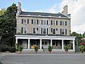
The historic Frontier House in Lewiston.

See also
 In Spanish: Lewiston (Nueva York) para niños
