
Lomé facts for kids
Quick facts for kids
Lomé
|
||
|---|---|---|
|
From top, left to right: Palace of the Governors, headquarters of the West African Development Bank, Monument Colombe de la Paix, Lomé Beach, and the Grande Marché in front of the Sacred Heart Cathedral.
|
||
|
||

Lomé
Location in Togo
|
||
| Country | ||
| Region | Maritime Region | |
| Prefecture | Golfe | |
| Area | ||
| • Capital city | 99.14 km2 (38.28 sq mi) | |
| • Metro | 280 km2 (110 sq mi) | |
| Elevation | 10 m (30 ft) | |
| Population
(2022 census)
|
||
| • Capital city | 1,500,000 | |
| • Density | 15,000/km2 (40,000/sq mi) | |
| • Metro | 2,200,000 | |
| • Metro density | 7,150/km2 (18,500/sq mi) | |
| Time zone | UTC+00:00 (Greenwich Mean Time) | |
| • Summer (DST) | (Not Observed) | |
| HDI (2019) | 0.610 medium · 1st |
|


.jpg)

.jpg)

Lomé is the capital and largest city of Togo, a country in West Africa. It is home to about 1.5 million people in the city itself, and over 2 million in the wider metropolitan area.
The city is located on the Gulf of Guinea, which is part of the Atlantic Ocean. Its western border is very close to Ghana, near the city of Aflao. Lomé is a very important place for Togo, serving as its main administrative and industrial hub. It also has the country's biggest port. From this port, Togo exports products like coffee, cocoa, and palm oil kernels.
Contents
- What Does the Name Lomé Mean?
- A Brief Look at Lomé's History
- Lomé's Climate
- Lomé's Geography and Location
- Districts and Neighborhoods of Lomé
- Important International Agreements in Lomé
- Lomé's Economy
- Lomé's Population Growth
- Culture in Lomé
- Lomé's Architecture and Buildings
- Places of Worship
- Education in Lomé
- Transportation in Lomé
- Twin Towns and Sister Cities
- Famous People from Lomé
- Images for kids
- See also
What Does the Name Lomé Mean?
The name 'Lomé' comes from the Ewe language. It means "in the alo trees" or "within the alo trees." This name simply refers to a forest of alo trees.
A Brief Look at Lomé's History
.jpg)
The Ewe people first founded Lomé. In the 1800s, traders from Germany, Britain, and Africa helped the city grow. It became the capital of Togoland in 1897.
Around 1880, British taxes on goods like alcohol and tobacco were very high in nearby areas. Traders looked for a place to unload their goods without paying these high taxes. Lomé, with its quiet coastline, became the perfect spot. This made Lomé grow quickly as a trading center.
Soon, European companies and traders from inland areas, like the Hausa people, were also attracted to Lomé. The city became known as a great place to do business.
Lomé During Colonial Times

To protect their trade from British influence, local leaders asked for Germany's help. This led to the creation of Togoland as a German colony in 1884. The Treaty of Togoville officially established this.
Lomé continued to thrive as a key import center. It became the main gateway to the northern parts of the country. The first major road, Lomé-Kpalimé, was built starting in 1892 to connect to the Volta Valley. Because of its economic importance, the German government moved the capital to Lomé.

In 1904, Lomé got a port, making it Togo's only sea contact point. This helped it grow even more. A network of railways was built, connecting Lomé to other cities like Aného, Kpalimé, and Atakpamé. By 1914, Lomé had about 8,000 people.
The Germans also built important services like a post office, telephone lines, a cathedral, and a bank. However, they introduced rules that made it harder for African traders to do the most profitable business, like import-export.
During World War I, Lomé was not directly affected by fighting. After the war, German companies left, and British and French firms took over. Many Togolese traders returned to Lomé and built successful businesses. They formed a group of wealthy citizens that the new French authorities had to work with.
The French improved the city's infrastructure, repairing railways and building new roads. They also brought electricity in 1926 and clean water in 1940. In the 1920s, low taxes helped the city prosper. However, the Great Depression in the 1930s caused a tough economic time. Many businesses closed, and investments stopped.
- Map of the city of Lomé in 1931
-
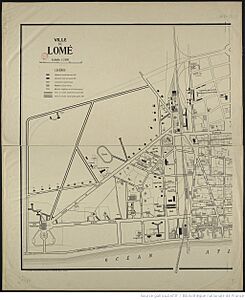
Left part
-
Right part


Lomé reached 15,000 people around 1930. After World War II, the city's economy boomed again.
Lomé After Independence

Lomé's population grew very quickly in the second half of the 20th century. In 1950, it had 30,000 people. By 1960, when Togo became independent, it had 80,000. Just ten years later, in 1970, the population was 200,000! This huge growth was due to high prices for export products and many new jobs created by colonial government projects.
From the mid-1970s, large projects were built, but not all were successful. Togo is a small country, and some big industries and luxury hotels didn't have enough customers to thrive. Also, the railway system was allowed to decline, even though it was important for connecting different parts of the city.
Many people in Lomé make a living through what is called the "informal sector." This includes countless small activities like making goods, trading, offering services, and repairs. These jobs help most people in the city earn money and get the services they need.
Another important activity is market gardening around the city. As more people moved from rural areas to the city and unemployment grew, the demand for fresh vegetables increased. This led to more farming, even on the beach where the sand is less salty.
Lomé's neighborhoods are a mix of different types of homes, from fancy villas to modest houses. This is because people in Lomé are very attached to their land and their "home." However, the city faces challenges with collecting household waste and keeping the city clean.
Lomé's Climate
Lomé has a tropical savanna climate. This means it's generally warm all year. Even though it's near the equator, it's relatively dry, getting about 800 to 900 millimeters (31 to 35 inches) of rain each year. It rains on about 59 days a year.
The city often experiences heavy fog due to ocean currents. Lomé gets about 2,330 hours of sunshine each year. The average yearly temperature is around 26.9 °C (80.4 °F). The coolest month is July, with an average of 24.9 °C (76.8 °F). The hottest months are February and April, averaging 29.6 °C (85.3 °F).
| Climate data for Lomé (Lomé Airport) 1991-2020 normals, extremes 1892-present | |||||||||||||
|---|---|---|---|---|---|---|---|---|---|---|---|---|---|
| Month | Jan | Feb | Mar | Apr | May | Jun | Jul | Aug | Sep | Oct | Nov | Dec | Year |
| Record high °C (°F) | 35.7 (96.3) |
36.4 (97.5) |
36.3 (97.3) |
35.0 (95.0) |
34.8 (94.6) |
36.4 (97.5) |
32.8 (91.0) |
36.5 (97.7) |
35.5 (95.9) |
33.8 (92.8) |
38.1 (100.6) |
34.5 (94.1) |
38.1 (100.6) |
| Mean daily maximum °C (°F) | 32.8 (91.0) |
33.5 (92.3) |
33.4 (92.1) |
33.1 (91.6) |
32.4 (90.3) |
30.6 (87.1) |
29.3 (84.7) |
28.9 (84.0) |
29.9 (85.8) |
31.4 (88.5) |
32.9 (91.2) |
33.2 (91.8) |
31.8 (89.2) |
| Daily mean °C (°F) | 28.4 (83.1) |
29.4 (84.9) |
29.6 (85.3) |
29.3 (84.7) |
28.6 (83.5) |
27.3 (81.1) |
26.5 (79.7) |
26.2 (79.2) |
26.9 (80.4) |
27.7 (81.9) |
28.8 (83.8) |
28.8 (83.8) |
28.1 (82.6) |
| Mean daily minimum °C (°F) | 24.0 (75.2) |
25.5 (77.9) |
25.9 (78.6) |
25.6 (78.1) |
24.9 (76.8) |
24.1 (75.4) |
23.8 (74.8) |
23.4 (74.1) |
23.8 (74.8) |
24.0 (75.2) |
24.8 (76.6) |
24.4 (75.9) |
24.5 (76.1) |
| Record low °C (°F) | 15.2 (59.4) |
16.7 (62.1) |
19.9 (67.8) |
20.0 (68.0) |
19.2 (66.6) |
18.0 (64.4) |
16.7 (62.1) |
17.1 (62.8) |
18.0 (64.4) |
16.4 (61.5) |
18.6 (65.5) |
15.6 (60.1) |
15.2 (59.4) |
| Average precipitation mm (inches) | 13.3 (0.52) |
16.4 (0.65) |
67.3 (2.65) |
97.3 (3.83) |
148.8 (5.86) |
180.5 (7.11) |
74.4 (2.93) |
30.1 (1.19) |
72.3 (2.85) |
101.9 (4.01) |
20.4 (0.80) |
7.6 (0.30) |
830.3 (32.69) |
| Average precipitation days (≥ 1.0 mm) | 1.2 | 1.9 | 4.5 | 7.5 | 11.9 | 14.4 | 8.4 | 7.0 | 10.0 | 9.4 | 3.2 | 0.7 | 80.1 |
| Average relative humidity (%) | 79 | 81 | 82 | 82 | 84 | 86 | 87 | 86 | 86 | 85 | 84 | 82 | 84 |
| Mean monthly sunshine hours | 222.4 | 214.8 | 228.0 | 218.0 | 217.8 | 141.3 | 135.4 | 147.5 | 168.4 | 218.0 | 240.6 | 227.2 | 2,379.4 |
| Source 1: NOAA (humidity and sunshine 1961–1990) | |||||||||||||
| Source 2: Meteo Climat (record highs and lows) | |||||||||||||
How Climate Change Might Affect Lomé
Scientists have studied how climate change might affect cities like Lomé. One study suggests that by 2050, Lomé's climate could feel similar to Managua in Nicaragua. This means the average yearly temperature could increase by about 1 °C (1.8 °F).
Another report from 2022 warns that Lomé is one of 12 major African cities that could be greatly affected by sea level rise. This could cause billions of dollars in damage by 2050 if no actions are taken to adapt. Sea levels are expected to keep rising for thousands of years, making future costs even higher without protective measures.
| Jan | Feb | Mar | Apr | May | Jun | Jul | Aug | Sep | Oct | Nov | Dec |
|---|---|---|---|---|---|---|---|---|---|---|---|
| 28 °C (82 °F) | 28 °C (82 °F) | 29 °C (84 °F) | 29 °C (84 °F) | 29 °C (84 °F) | 28 °C (82 °F) | 26 °C (79 °F) | 25 °C (77 °F) | 25 °C (77 °F) | 27 °C (81 °F) | 28 °C (82 °F) | 28 °C (82 °F) |
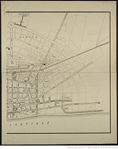
Lomé's Geography and Location
When Lomé was first created, it was located between a lagoon to the north and the Atlantic Ocean to the south. To the east was the village of Bè, and to the west was the border with Aflao in Ghana.
Today, Lomé has grown much larger. It now covers an area of 333 square kilometers (129 sq mi), including 30 square kilometers (12 sq mi) in the lagoon area. The city's services extend beyond its original boundaries to the north and east.
Distances from Lomé to other cities in Togo:
- Lomé to Tsévié: 35 km (22 mi)
- Lomé to Aného: 45 km (28 mi)
- Lomé to Tabligbo: 90 km (56 mi)
- Lomé to Notsé: 100 km (62 mi)
- Lomé to Kpalimé: 121 km (75 mi)
- Lomé to Atakpamé: 167 km (104 mi)
- Lomé to Blitta: 273 km (170 mi)
- Lomé to Sokodé: 355 km (221 mi)
- Lomé to Bafilo: 404 km (251 mi)
- Lomé to Bassar: 412 km (256 mi)
- Lomé to Kara: 428 km (266 mi)
- Lomé to Kandé: 503 km (313 mi)
- Lomé to Mango: 592 km (368 mi)
- Lomé to Dapaong: 662 km (411 mi)
Districts and Neighborhoods of Lomé
The city of Lomé is divided into 5 main areas, called arrondissements. These areas contain 69 smaller administrative districts.
- 1st Arrondissement: This is the historic part of the city, located along the ocean in the south. It includes 11 districts like Abobokomé and Quartier Administratif.
- 2nd Arrondissement: Located to the north and northeast, bordering the maritime region. It has 18 districts, including Akodesséwa-Kponou and Tokoin-Aéroport.
- 3rd Arrondissement: Found to the east, along the sea. It includes 17 districts such as Ablogamé and Akodésséwa.
- 4th Arrondissement: In the southwest, along the sea and bordering Ghana. It has 4 districts, including Hanukope and Nyékonakpoé.
- 5th Arrondissement: To the northwest, bordering Ghana to the east and the maritime region to the north. It includes 19 districts like Aflao Gakli and Totsi.
Some older districts that are now subdivided include Dékon, Tokoin, and Adidogomé. Other important towns that are part of the larger Lomé area are Agoè, Baguida, and Kpogan.
Important International Agreements in Lomé
Lomé has been the location for signing two important international agreements.
Lomé Convention
The Lomé Convention was an agreement about trade and aid between the European Union (EU) and 71 countries from Africa, the Caribbean, and the Pacific (ACP). It was first signed in Lomé on February 28, 1975.
Lomé Peace Accord
The Lomé Peace Accord was an agreement aimed at ending the civil war in Sierra Leone. It was signed in Lomé on July 7, 1999, by Sierra Leone's President Ahmad Tejan Kabbah and the leader of the Revolutionary United Front, Foday Sankoh. Even with international help, the agreement did not last, and the war continued for two more years.
Lomé's Economy
Lomé has a very important port, which includes a special free trade zone opened in 1968. This port is used to export products like phosphates, coffee, cocoa, cotton, and palm oil. A lot of trade for neighboring countries like Ghana, Mali, Niger, and Burkina Faso also passes through this port.
The port also has an oil refinery and a shipyard. The city produces building materials, including cement.
However, political challenges since the 1990s have affected tourism in Togo. In 2003, the country had about 57,539 visitors. Most tourists came from France, Burkina Faso, and Benin.
Lomé's Population Growth
| Historical population | |||||||||||||||||||||||||||||||||||||||||||||||||||||||
|---|---|---|---|---|---|---|---|---|---|---|---|---|---|---|---|---|---|---|---|---|---|---|---|---|---|---|---|---|---|---|---|---|---|---|---|---|---|---|---|---|---|---|---|---|---|---|---|---|---|---|---|---|---|---|---|
|
|
||||||||||||||||||||||||||||||||||||||||||||||||||||||
Culture in Lomé
The Togo National Museum is located in the Palais de Congrès (Congress Palace). This museum has many collections, including jewelry, musical instruments, dolls, pottery, and weapons. These items show the rich arts and traditions of Togo.
Lomé's Architecture and Buildings
.jpg)
.jpg)
.jpg)
The center of Lomé dates back to the early 1900s. You can still see some buildings from the colonial era, such as the Palace of the Governors and the Sacred Heart Cathedral, which has a German neo-Gothic style.
Lomé also has many modern buildings. These include the headquarters of important banks like the Central Bank of West African States (BCEAO) and the West African Development Bank (BOAD). There are also large hotels like the Hotel de la Paix and the famous Hotel du 2 Février, which is the tallest building in Togo with 36 floors.
Near the city center is the Grand Market. This market has three floors where you can find all sorts of goods, from spices and dried fish to traditional medicines. On the first floor, you'll find the famous "Nana Benz" — women who are well-known for selling many different colorful fabrics.
To the west of the city is a residential area with long streets and official buildings like the Palace of Justice and various embassies. Further north, near the Independence Monument, is a major convention center.
Places of Worship
-
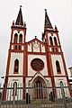
Sacred Heart Cathedral, Lomé (Catholic Church)
-
The Savior Baptist Church in Lomé (Togo Baptist Convention)


Lomé has many places of worship. Most are Christian churches and temples, including the Roman Catholic Archdiocese of Lomé (Catholic Church), the Evangelical Presbyterian Church of Togo, and various Baptist and Pentecostal churches. There are also Muslim mosques.
Education in Lomé
.jpg)
The University of Lomé, which was once called the University of Benin, was founded in 1970. It is located in the Tokoin area of Lomé.
Several international schools are also in the city, such as the American International School of Lomé, the British School of Lomé, and the Lycée Français de Lomé.
Transportation in Lomé
Road Travel
For getting around the city, there are some taxis. However, motorcycle taxis, known as zémidjans, are the most common way people travel.
Train Travel
Lomé did not have train service for many years, but trains returned in 2014. A new train station was built by a French company called Bolloré. The first train ran a short distance from Lomé to Cacavéli. There are plans to build a railway link between Lomé and Cotonou, which is part of a larger project to connect several West African cities by rail. This project is expected to be finished by 2024.
Air Travel
The city is served by Lomé-Tokoin International Airport, which is about 5 kilometers (3 miles) northeast of the city center. ASKY Airlines, an airline that is part of Ethiopian Airlines, operates from this airport.
Water Travel
Lomé has the Port of Lomé, which is Togo's only commercial port. It handles all of the country's trade and import-export activities. The port also has a cruise terminal for passengers.
-
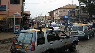
Taxis.
-
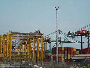
Port of Lomé.
-
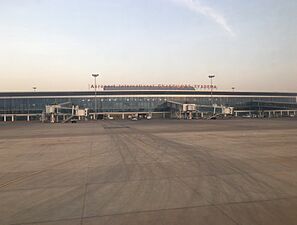
Lomé–Tokoin International Airport.


Twin Towns and Sister Cities
Lomé has special partnerships with other cities around the world. These are called "twin towns" or "sister cities."
Famous People from Lomé
Many notable people were born or grew up in Lomé, including:
- Emmanuel Adebayor, a famous retired footballer who played for the Togo national football team.
- Kangni Alem, a writer.
- King Mensah, a popular Afropop musician.
- Marie Madoé Sivomey, the first female mayor in Togo, who served as mayor of Lomé from 1967 to 1974.
Images for kids
-
Palace of the Governors
-

Headquarters of the West African Development Bank
-
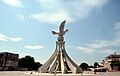
Monument Colombe de la Paix
-
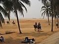
Lomé Beach
-
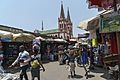
Grande Marché in front of the Sacred Heart Cathedral
See also
 In Spanish: Lomé para niños
