Luce County, Michigan facts for kids
Quick facts for kids
Luce County
|
|
|---|---|

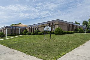
Luce County Courthouse in Newberry
|
|

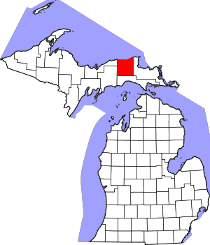
Location within the U.S. state of Michigan
|
|
 Michigan's location within the U.S. |
|
| Country | |
| State | |
| Founded | 1887 |
| Named for | Cyrus G. Luce |
| Seat | Newberry |
| Largest village | Newberry |
| Area | |
| • Total | 1,912 sq mi (4,950 km2) |
| • Land | 899 sq mi (2,330 km2) |
| • Water | 1,013 sq mi (2,620 km2) 53%% |
| Population
(2020)
|
|
| • Total | 5,339 |
| • Density | 7.4/sq mi (2.9/km2) |
| Time zone | UTC−5 (Eastern) |
| • Summer (DST) | UTC−4 (EDT) |
| Congressional district | 1st |
Luce County (pronounced LOOS) is a county located in the Upper Peninsula of Michigan, a state in the United States. In 2020, about 5,339 people lived here. This makes it one of the least populated counties in Michigan. The main town, called the county seat, is Newberry. Newberry is the only official community in Luce County.
Luce County was officially created in 1887. It was named after Cyrus G. Luce, who used to be the governor of Michigan. In 2002, the state of Michigan named Newberry the "moose capital" because many moose live in the area. The county has its own weekly newspaper, The Newberry News, which started in 1886.
Contents
Geography of Luce County
Luce County covers a total area of about 1,912 square miles (4,950 square kilometers). More than half of this area, about 1,013 square miles (2,624 square kilometers), is water. The rest, about 899 square miles (2,328 square kilometers), is land.
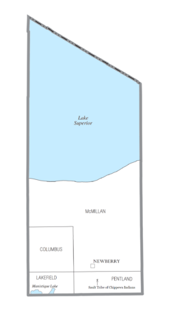
Luce County is part of Michigan's Upper Peninsula. It shares a northern border with Canada across Lake Superior. McMillan Township is located in Luce County. It is the largest local government area in Michigan by land size.
Main Roads
Several important roads help people travel through Luce County:
 M-28 is the longest state highway in Michigan. It runs east and west. You can use it to go to Sault Ste. Marie in the east or Munising and Marquette in the west.
- M-117 connects M-28 (west of Newberry) to US 2 in Mackinac County.
 M-123 is a u-shaped road that starts south of Newberry. This road is used to reach popular places like Tahquamenon Falls and Whitefish Point.
- Other county roads include
 H-33,
H-33,  H-37,
H-37,  H-44, and
  H-58.
H-58.
Airport
The Luce County Airport (KERY) serves the county and nearby towns.
Neighboring Counties
Luce County shares borders with these other counties:
- Chippewa County (east)
- Mackinac County (south)
- Schoolcraft County (southwest)
- Alger County (west)
- Thunder Bay District, Ontario (north, in Canada)
- Algoma District, Ontario (northeast, in Canada)
Communities in Luce County
Village
- Newberry (This is the main town, also called the county seat.)
Townships
These are areas of land with their own local governments:
- Columbus Township
- Lakefield Township
- McMillan Township
- Pentland Township
Smaller Communities
These are smaller places that are not officially incorporated as towns or villages:
- Betty B Landing
- Carpenter Landing
- Danaher
- Deer Park
- Dollarville
- Eightmile Corner
- Fourmile Corner
- Helmer
- Laketon
- Lencel
- Marks
- McLeods Corner
- McMillan
- McMillan Corner
- McPhees Landing
- Natalie
- Pine Stump Junction
- Roberts Corner
- Soo Junction
Native American Lands
Luce County includes a very small part of the Sault Tribe of Chippewa Indians tribal community. This land is within Pentland Township but is managed by the tribe itself.
People of Luce County
| Historical population | |||
|---|---|---|---|
| Census | Pop. | %± | |
| 1890 | 2,455 | — | |
| 1900 | 2,983 | 21.5% | |
| 1910 | 4,004 | 34.2% | |
| 1920 | 6,149 | 53.6% | |
| 1930 | 6,528 | 6.2% | |
| 1940 | 7,423 | 13.7% | |
| 1950 | 8,147 | 9.8% | |
| 1960 | 7,827 | −3.9% | |
| 1970 | 6,789 | −13.3% | |
| 1980 | 6,659 | −1.9% | |
| 1990 | 5,763 | −13.5% | |
| 2000 | 7,024 | 21.9% | |
| 2010 | 6,631 | −5.6% | |
| 2020 | 5,339 | −19.5% | |
| 2023 (est.) | 6,435 | −3.0% | |
| U.S. Decennial Census 1790-1960 1900-1990 1990-2000 2010-2018 |
|||
In 2010, the population of Luce County was 6,631 people. By 2020, the population had decreased to 5,339 people. This means fewer people live there now compared to ten years ago. The county has about 7 people per square mile.
Most people in Luce County are White. There are also groups of Black or African American people and Native American people. Some people are from German, French, Irish, English, or Finnish backgrounds.
In 2010, about 18% of the people were under 18 years old. The average age of people in the county was 43 years old. More men live in Luce County than women.
The main religion in Luce County is Christianity. The largest Christian groups are Roman Catholicism and the Evangelical Lutheran Church in America.
See also
 In Spanish: Condado de Luce para niños
Images for kids
 | Jewel Prestage |
 | Ella Baker |
 | Fannie Lou Hamer |


