Magor, Monmouthshire facts for kids
Quick facts for kids Magor
|
|
|---|---|
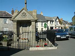 War memorial in the centre of Magor Square |
|
| Population | 6,140 (2011) |
| OS grid reference | ST425871 |
| Community |
|
| Principal area | |
| Ceremonial county | |
| Country | Wales |
| Sovereign state | United Kingdom |
| Post town | CALDICOT |
| Postcode district | NP26 |
| Dialling code | 01633 |
| Police | Gwent |
| Fire | South Wales |
| Ambulance | Welsh |
| EU Parliament | Wales |
| UK Parliament |
|
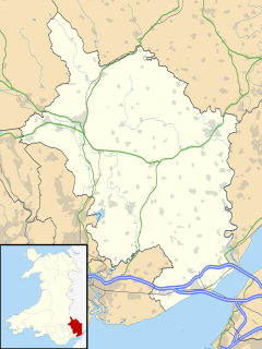
Magor (pronounced MAY-gor) is a big village in Monmouthshire, which is in south east Wales. It's about 9 miles (14 km) west of Chepstow and 9 miles (14 km) east of Newport. The village sits on the Caldicot Levels next to the Severn Estuary. Magor is part of the community called Magor with Undy. It is also very close to the M4 motorway.
Contents
Discovering Magor's Past
The Welsh name for Magor is Magwyr. This name probably comes from the Latin word maceria. That word means masonry walls or ruins. It might refer to an old Roman building that is now gone. Or, it could mean old sea walls or a raised path built by the Romans.
Magor and the areas around it have many Roman ruins and old objects. The village centre was once at the edge of salty marshes. The Romans started to turn these marshes into farmland. A local name, "Whitewall," might be for a Roman path. This path would have linked the village to a small harbour. That harbour, called Abergwaitha, has now disappeared.
In 1994, something exciting was found near Magor Pill. It was the remains of a boat from the 1200s! This boat was used for trading along the Severn Estuary. It might even have travelled to Ireland. When found, the boat was carrying iron ore from Glamorgan.
Magor, spelled "Magur," is one of the few villages shown on a map from 1573. This map was called the Cambriae Typus.
Exploring St Mary's Church
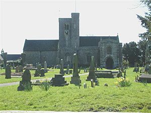
St Mary's Church is a very important historical building. It is a Grade I listed building, meaning it is protected. It is part of the Netherwent Ministry Area.
People believe the church was first built in the 600s. It was originally named after St. Leonard. The church you see today is described as one of the most impressive churches in Monmouthshire. The oldest parts of the building are from the 1200s. Around that time, Gilbert Marshal gave the church to the Abbey of Anagni in Italy. Later, Tintern Abbey looked after it.
The church was made much bigger in the 1400s. In the mid-1800s, it was repaired and renamed after St. Mary.
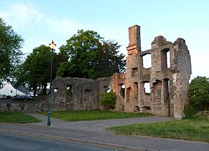
You can still see parts of The Procurator's House near the village square. Some parts might be from the 1300s, and others from the 1500s. A procurator was a person who collected money or goods for the abbey.
The Welsh composer Mansel Thomas (1909–1986) is buried at this church.
What Can You Do in Magor?
Magor has a lively village centre. You can find shops, pubs, restaurants, and a Post Office there. Besides the large St Mary's Church, there is also an old Baptist church.
Magor and the nearby village of Undy have a great athletic club. Their clubhouse and sports fields are at the east end of the villages. Undy includes all the land north of the Magor reen (a drainage ditch). This area includes Dancing Hill, Millfield Park, and Mill Reen. Vinegar Hill, often seen as a border, is actually all in Undy.
Discovering Magor Marsh
Magor Marsh is a 90-acre (36 hectare) wetland nature reserve. The Gwent Wildlife Trust looks after it. This reserve has many different natural areas. These include damp hay meadows, sedge fen, and areas with reeds. There are also bushes, wet woodlands, a large pond, and many drainage ditches called reens.
Many birds breed here, like common snipe and common redshank. You can also find reed warblers, grasshopper warblers, and Cetti's warblers. Magor Marsh is the best place in Wales for wetland beetles. It is also great for soldier-flies. The way the drainage ditches are laid out has not changed since the 1300s!
Close to the village, at Junction 23A of the M4 motorway, is Magor services. This is a motorway service area that opened in 1996.
Magor's Development and Changes
In 2007, a new road for the M4 motorway was suggested for Newport. It was planned to be built west of Magor, using the existing motorway junction. However, these plans were stopped in 2009.
Monmouthshire County Council moved many of its office staff to Innovation House in Magor. This building is on the Wales 1 Business Park, next to the motorway. This move happened in 2011. It was because their old offices had a problem called "concrete cancer."
Magor's Railway History
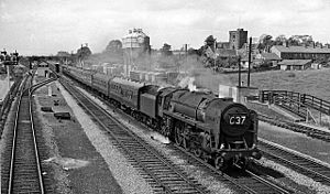
The South Wales Railway line went through Magor. This line connected Swansea and Chepstow (and later Gloucester). A station opened here in the 1850s, soon after the line began. The station had three sidings, which are extra tracks. These sidings helped local farmers.
By the 1920s, many trains were using the line. So, extra sidings were added for trains to wait. In 1941, the main line was made bigger. It became four tracks. The two outer tracks were for slow goods trains only. This helped move more coal during wartime without slowing down fast trains.
Magor station closed in November 1964, along with Undy Halt. However, the goods yard stayed open until 1965. It was used for cement trains that helped build the M4 motorway.
Notable People
- See Category:People from Magor, Monmouthshire
 | James B. Knighten |
 | Azellia White |
 | Willa Brown |


