Malvern, Arkansas facts for kids
Quick facts for kids
Malvern, Arkansas
|
|
|---|---|

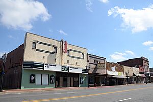
Downtown Malvern
|
|
| Nickname(s):
Brick Capital of the World
|
|

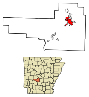
Location of Malvern in Hot Spring County, Arkansas.
|
|
| Country | |
| State | |
| County | Hot Spring |
| Townships | Butterfield, Fenter |
| Incorporated | July 22, 1876 |
| Named for | Malvern Hill, Virginia |
| Government | |
| • Type | Mayor-Council |
| Area | |
| • Total | 9.92 sq mi (25.69 km2) |
| • Land | 9.86 sq mi (25.55 km2) |
| • Water | 0.06 sq mi (0.14 km2) |
| Elevation | 315 ft (96 m) |
| Population
(2020)
|
|
| • Total | 10,867 |
| • Density | 1,101.68/sq mi (425.38/km2) |
| Time zone | UTC-6 (Central (CST)) |
| • Summer (DST) | UTC-5 (CDT) |
| ZIP code |
72104
|
| Area code(s) | 501 |
| FIPS code | 05-43610 |
| GNIS feature ID | 2405001 |
| Major airport | Adams Field (LIT) |
Malvern is a city in Arkansas, United States. It is also the county seat of Hot Spring County. The city was founded as a railroad stop on the eastern edge of the Ouachita Mountains.
Malvern's history and economy are closely linked to its natural resources, like farming and minerals. The city is famous for making bricks from local clay. This has earned Malvern the nickname, "The Brick Capital of the World". In 2020, about 10,867 people lived in Malvern.
Contents
History of Malvern
Malvern was named after Malvern Hill, Virginia. It was started in 1870 by the Cairo and Fulton Railroad company. They chose a spot about 21 miles southeast of Hot Springs for the new city. On October 15, 1878, Malvern officially became the main city, or county seat, of Hot Spring County. The first people living in the area were Native Americans, trappers, hunters, and farmers.
The Diamond Jo Railroad
The Hot Springs Railroad, also known as the Diamond Jo line, was built in 1874. A businessman named Joseph Reynolds started this narrow-gauge railroad. It went northwest from Malvern Junction to Hot Springs. Reynolds built it because he had bad experiences traveling to Hot Springs by stagecoach.
Malvern became an important stop because it was the closest train station to Hot Springs. Travelers would get off the train in Malvern and then take a stagecoach to reach the spas in Hot Springs. This was the only railroad into Hot Springs for 15 years.
Later, in 1900, a new railroad opened directly connecting Hot Springs to Little Rock. This new route meant fewer people needed to transfer in Malvern. By 1902, train shuttle service through Malvern had mostly stopped.
Malvern Police Department History
During the 1930s, the Malvern Police Department lost four officers while they were on duty. Deputy Carson Smith and officers Clyde Davis, Leslie Lee Potts, and Hiram Potts all lost their lives. Clyde Davis and Leslie Lee Potts were both killed during a domestic dispute in 1933. Hiram Potts, who was related to Leslie Lee Potts, was killed in 1935 while trying to arrest two men illegally boarding a train.
World War II Impact
During World War II, many people from Malvern moved to the Los Angeles area. They went there to work in shipyards. This happened after some residents found good jobs there and wrote home about the high wages.
Geography and Climate
Malvern is located in the northeastern part of Hot Spring County. It is southeast of the Ouachita River, where the river leaves the Ouachita Mountains. The city borders Rockport to the north and Perla to the east.
Major Roads
Interstate 30 runs through the northwest part of Malvern. You can get on or off I-30 at Exits 97, 98, and 99. I-30 goes northeast about 44 miles to Little Rock, the state capital. It goes southwest about 100 miles to Texarkana.
U.S. Route 67 (Page Avenue) goes through the center of Malvern. It leads northeast about 22 miles to Benton and southwest about 25 miles to Arkadelphia. U.S. Route 270 passes northeast of Malvern on a bypass. It goes east about 24 miles to Sheridan and northwest about 20 miles to Hot Springs. Arkansas Highway 9 (Main Street) goes south from the center of Malvern about 64 miles to Camden.
City Area
The United States Census Bureau says Malvern covers a total area of about 9.92 square miles (25.69 square kilometers). Most of this area, about 9.86 square miles (25.55 square kilometers), is land. The rest, about 0.06 square miles (0.14 square kilometers), is water.
Climate in Malvern
Malvern has a humid subtropical climate. This means it has hot, humid summers. The winters are generally mild to cool.
| Climate data for Malvern, Arkansas (1991–2020 normals, extremes 1883–present) | |||||||||||||
|---|---|---|---|---|---|---|---|---|---|---|---|---|---|
| Month | Jan | Feb | Mar | Apr | May | Jun | Jul | Aug | Sep | Oct | Nov | Dec | Year |
| Record high °F (°C) | 81 (27) |
88 (31) |
91 (33) |
96 (36) |
101 (38) |
107 (42) |
114 (46) |
112 (44) |
109 (43) |
100 (38) |
89 (32) |
82 (28) |
114 (46) |
| Mean maximum °F (°C) | 71.1 (21.7) |
74.8 (23.8) |
82.0 (27.8) |
86.2 (30.1) |
89.9 (32.2) |
95.5 (35.3) |
99.0 (37.2) |
100.0 (37.8) |
95.5 (35.3) |
89.1 (31.7) |
78.3 (25.7) |
72.3 (22.4) |
101.3 (38.5) |
| Mean daily maximum °F (°C) | 51.8 (11.0) |
56.1 (13.4) |
65.0 (18.3) |
73.7 (23.2) |
80.6 (27.0) |
88.1 (31.2) |
91.9 (33.3) |
91.6 (33.1) |
85.7 (29.8) |
74.8 (23.8) |
62.1 (16.7) |
53.7 (12.1) |
72.9 (22.7) |
| Daily mean °F (°C) | 40.6 (4.8) |
44.1 (6.7) |
52.5 (11.4) |
60.9 (16.1) |
69.6 (20.9) |
77.3 (25.2) |
80.9 (27.2) |
80.0 (26.7) |
73.9 (23.3) |
62.5 (16.9) |
50.6 (10.3) |
42.9 (6.1) |
61.3 (16.3) |
| Mean daily minimum °F (°C) | 29.4 (−1.4) |
32.2 (0.1) |
40.0 (4.4) |
48.1 (8.9) |
58.6 (14.8) |
66.5 (19.2) |
70.0 (21.1) |
68.4 (20.2) |
62.1 (16.7) |
50.2 (10.1) |
39.0 (3.9) |
32.1 (0.1) |
49.7 (9.8) |
| Mean minimum °F (°C) | 14.5 (−9.7) |
19.7 (−6.8) |
24.0 (−4.4) |
32.6 (0.3) |
44.3 (6.8) |
56.7 (13.7) |
63.0 (17.2) |
61.4 (16.3) |
48.2 (9.0) |
34.2 (1.2) |
24.6 (−4.1) |
19.0 (−7.2) |
12.3 (−10.9) |
| Record low °F (°C) | −11 (−24) |
−10 (−23) |
11 (−12) |
24 (−4) |
33 (1) |
44 (7) |
51 (11) |
43 (6) |
31 (−1) |
25 (−4) |
9 (−13) |
−2 (−19) |
−11 (−24) |
| Average precipitation inches (mm) | 4.24 (108) |
4.59 (117) |
5.55 (141) |
6.05 (154) |
5.53 (140) |
4.64 (118) |
4.21 (107) |
3.68 (93) |
3.95 (100) |
4.63 (118) |
5.04 (128) |
5.37 (136) |
57.48 (1,460) |
| Average snowfall inches (cm) | 0.5 (1.3) |
0.5 (1.3) |
0.2 (0.51) |
0.0 (0.0) |
0.0 (0.0) |
0.0 (0.0) |
0.0 (0.0) |
0.0 (0.0) |
0.0 (0.0) |
0.0 (0.0) |
0.0 (0.0) |
0.0 (0.0) |
1.2 (3.0) |
| Average precipitation days (≥ 0.01 in) | 8.1 | 8.4 | 9.8 | 8.9 | 10.3 | 7.6 | 8.0 | 7.6 | 6.2 | 7.6 | 8.0 | 9.1 | 99.6 |
| Average snowy days (≥ 0.1 in) | 0.2 | 0.3 | 0.2 | 0.0 | 0.0 | 0.0 | 0.0 | 0.0 | 0.0 | 0.0 | 0.0 | 0.0 | 0.7 |
| Source: NOAA | |||||||||||||
Population and People
| Historical population | |||
|---|---|---|---|
| Census | Pop. | %± | |
| 1890 | 1,520 | — | |
| 1900 | 1,582 | 4.1% | |
| 1910 | 2,778 | 75.6% | |
| 1920 | 3,364 | 21.1% | |
| 1930 | 5,115 | 52.1% | |
| 1940 | 5,290 | 3.4% | |
| 1950 | 8,072 | 52.6% | |
| 1960 | 9,566 | 18.5% | |
| 1970 | 8,739 | −8.6% | |
| 1980 | 10,163 | 16.3% | |
| 1990 | 9,256 | −8.9% | |
| 2000 | 9,021 | −2.5% | |
| 2010 | 10,318 | 14.4% | |
| 2020 | 10,867 | 5.3% | |
| U.S. Decennial Census | |||
2020 Census Information
In 2020, the 2020 United States census counted 10,867 people living in Malvern. There were 3,911 households and 2,407 families in the city.
The table below shows the different groups of people living in Malvern based on the 2020 census:
| Race | Number | Percentage |
|---|---|---|
| White (non-Hispanic) | 6,492 | 59.74% |
| Black or African American (non-Hispanic) | 3,050 | 28.07% |
| Native American | 36 | 0.33% |
| Asian | 48 | 0.44% |
| Pacific Islander | 8 | 0.07% |
| Other/Mixed | 609 | 5.6% |
| Hispanic or Latino | 624 | 5.74% |
Malvern's Economy
Malvern is home to several manufacturing companies. It has three Acme Brick plants, which make bricks. Other companies include Weyerhaeuser, Borden Chemical, Adams Face Veneer Company, and Pactiv. Malvern is also where Grapette International is located, which makes Grapette soda. The city also has the Ouachita River Unit, which is a medium security prison.
Fun Things to Do
Yearly Events
Every year, on the last weekend of June, Malvern City Park hosts an event called Brickfest. This festival fills the city with music, food, and fun activities. These activities include a brick toss, a brick car derby, and a contest for the best-dressed brick. Malvern also has "Malvern Cruise Nite" once a month. In the fall, the city hosts the Hot Spring County Fair and Rodeo.
Places to Visit
You can find a lot of history in downtown Malvern. Ten places in the city are listed on the National Register of Historic Places. The art deco Hot Spring County Courthouse, built in 1936, is at 210 Locust Street. It has been the center of the county government for a long time.
Also downtown is the Bank of Malvern building. This building is important because it shows how Malvern changed from a farming economy to one based on industry. The Hot Spring County Museum is located in the Boyle House at 302 East Third Street in Malvern.
Malvern has one of two whitewater parks in Arkansas, located on the Ouachita River. This park is used to train Olympic kayakers and river rescue teams. The river has a special ledge that creates whitewater all year round, thanks to a dam release. There is also a zip line and a nature hike available along Ouachita Bend.
Education in Malvern
Schools for Kids
Public education for students in Malvern is provided by the Malvern School District. Students attend schools in this district from early childhood through high school. They graduate from Malvern High School.
Some other school districts, like Glen Rose School District and Magnet Cove School District, have Malvern postal addresses. However, their schools, such as Glen Rose High School and Magnet Cove High School, are not actually inside Malvern city limits.
College Education
For college-level education, Malvern is home to Arkansas State University Three Rivers.
Media and News
The city's newspaper is the Malvern Daily Record. It started in 1916 and publishes an afternoon edition from Tuesday through Friday. It also has a "Weekend Edition" on Saturday mornings. Malvern has two radio stations: KLBL (101.5), which plays Classic Hits, and KZYP AM-1310, which is a sports station.
Getting Around Malvern
Malvern is connected by major roads like Interstate 30, U.S. Route 270, and U.S. Route 67.
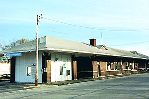
You can also travel by train. Amtrak's Texas Eagle train offers daily passenger service to Malvern. This train travels from Chicago to Dallas and Los Angeles. For shipping goods, railroad freight service in Malvern is provided by the Union Pacific Railroad and the Arkansas Midland Railroad. The Arkansas Midland Railroad uses the same route as the original Hot Springs Railroad.
The Malvern Municipal Airport (FAA Identifier: M78) serves the Malvern area for air travel.
Famous People from Malvern
Many notable people have connections to Malvern:
- Julie Adams, actress
- Homer Martin Adkins, former governor of Arkansas
- Fran Bennett, actress
- Frank Bonner, actor and director
- Winston Bryant, politician
- Bob Burrow, retired basketball player
- Beth Clayton, operatic mezzo-soprano
- Isaac Davis, National Football League player
- Susan Dunn, Grammy Award-winning operatic soprano
- Blaze Foley, country music singer-songwriter
- David Delano Glover, lawyer and U.S. representative
- Claris G. "Crip" Hall, former Arkansas Secretary of State
- Madre Hill, former NFL player
- Fred Jones, National Basketball Association player
- Tommy McCraw, former MLB player and hitting coach
- Tony Ollison, former football player for the Arkansas Razorbacks, Dallas Cowboys, and Dallas Desperados
- Reggie Ritter, professional baseball player
- Gerald Skinner, former National Football League player
- Billy Bob Thornton, actor, writer, and director
- Keith Traylor, NFL player
- Jerry Van Dyke, actor and comedian
- Frederick Yates, Michigan state legislator and lawyer
See also
 In Spanish: Malvern (Arkansas) para niños


