
McHenry County, North Dakota facts for kids
Quick facts for kids
McHenry County
|
|
|---|---|

McHenry County Courthouse
|
|

Location within the U.S. state of North Dakota
|
|
 North Dakota's location within the U.S. |
|
| Country | |
| State | |
| Founded | January 4, 1873 (created) October 15, 1884 (organized) |
| Seat | Towner |
| Largest city | Velva |
| Area | |
| • Total | 1,912 sq mi (4,950 km2) |
| • Land | 1,874 sq mi (4,850 km2) |
| • Water | 38 sq mi (100 km2) 2.0% |
| Population
(2020)
|
|
| • Total | 5,345 |
| • Estimate
(2022)
|
5,189 |
| • Density | 2.7955/sq mi (1.0793/km2) |
| Time zone | UTC−6 (Central) |
| • Summer (DST) | UTC−5 (CDT) |
| Congressional district | At-large |
McHenry County is a county located in the state of North Dakota in the United States. In 2020, about 5,345 people lived here. The main town, or county seat, is Towner. McHenry County is also part of the larger Minot area.
Contents
History
McHenry County was first created on January 4, 1873, by the government of the Dakota Territory. It was named after James McHenry, who was an early settler in the area. However, the county didn't have its own local government until October 15, 1884.
Over the years, the county's borders changed a few times. These changes happened in 1885, 1887, 1891, and 1892. Since 1892, the county's shape and size have stayed the same.
When the county first got its government in 1884, the county seat was a town called Villard. A county seat is the town where the main government offices are located. In 1885, the county seat moved to Scriptown. Then, in 1886, it moved again to Towner, where it has been ever since. Both Villard and Scriptown are now "ghost towns," meaning they are no longer inhabited.
Geography
McHenry County is a place with rolling hills, and much of the land is used for farming. The Souris River flows through the county, making a loop before heading north towards Lake Winnipeg. Another river, the Wintering River, drains the southern part of the county.
The highest point in the county is about 2,156 feet (657 meters) above sea level. This spot is located near the southwest corner of the county. The county covers a total area of 1,912 square miles (4,952 square kilometers). Most of this area, 1,874 square miles (4,854 square kilometers), is land. The remaining 38 square miles (98 square kilometers) is water, which is about 2% of the total area.
In 2013, scientists found 131 different types of plants in the Lake George area of the county.
Major highways
 U.S. Highway 2
 U.S. Highway 52
 North Dakota Highway 14
 North Dakota Highway 19
 North Dakota Highway 41
 North Dakota Highway 53
 North Dakota Highway 97
Adjacent counties
- Bottineau County - north
- Pierce County - east
- Sheridan County - southeast
- McLean County - southwest
- Ward County - west
- Renville County - northwest
National protected areas
- Cottonwood Lake National Wildlife Refuge
- Denbigh Experimental Forest
- J. Clark Salyer National Wildlife Refuge (part)
- Wintering River National Wildlife Refuge
Lakes
- Bromley Lake
- Buffalo Lodge Lake
- Connia Slough
- Erickson Lake
- Heringen Lake
- Horseshoe Lake (part)
- Lake George
- Lake Hester
- Lauinger Lake
- Martin Lake
- North Lake
- Potters Lake
- Round Lake
- Smoky Lake (part)
- Stevens Slough
- Stink Lake
Population and People
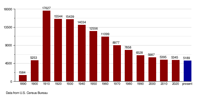
| Historical population | |||
|---|---|---|---|
| Census | Pop. | %± | |
| 1890 | 1,584 | — | |
| 1900 | 5,253 | 231.6% | |
| 1910 | 17,627 | 235.6% | |
| 1920 | 15,544 | −11.8% | |
| 1930 | 15,439 | −0.7% | |
| 1940 | 14,034 | −9.1% | |
| 1950 | 12,556 | −10.5% | |
| 1960 | 11,099 | −11.6% | |
| 1970 | 8,977 | −19.1% | |
| 1980 | 7,858 | −12.5% | |
| 1990 | 6,528 | −16.9% | |
| 2000 | 5,987 | −8.3% | |
| 2010 | 5,395 | −9.9% | |
| 2020 | 5,345 | −0.9% | |
| 2022 (est.) | 5,189 | −3.8% | |
| U.S. Decennial Census 1790-1960 1900-1990 1990-2000 2010-2020 |
|||
The population of McHenry County has changed a lot over the years. In 1890, there were only 1,584 people. The population grew a lot in the early 1900s, reaching its highest point in 1910 with 17,627 people. Since then, the population has slowly decreased.
Recent Population Numbers
According to the census in 2020, there were 5,345 people living in McHenry County. A census is an official count of the population.
In the 2010 census, there were 5,395 people. Most of the people living in the county were white (97.8%). A small number of people were American Indian (0.6%), Asian (0.3%), or Black (0.1%). Some people identified as being from two or more races (0.9%). About 1.5% of the population was of Hispanic or Latino origin.
Many people in McHenry County have German (55.3%) or Norwegian (39.5%) family backgrounds. Other ancestries include English, Swedish, American, Russian, and Dutch.
The average age of people in the county in 2010 was 46.2 years old. This means that half the population was older than 46.2 and half was younger.
Population by decade
Communities
McHenry County has several towns and smaller communities.
Cities
Census-designated place
- Bantry (used to be a city)
Unincorporated communities
Townships
- Anamoose
- Balfour
- Bantry
- Berwick
- Bjornson
- Brown
- Cottonwood Lake
- Deep River
- Deering
- Denbigh
- Egg Creek
- Falsen
- Gilmore
- Granville
- Grilley
- Hendrickson
- Karlsruhe
- Kottke Valley
- Lake George
- Lake Hester
- Land
- Layton
- Lebanon
- Little Deep
- Meadow
- Mouse River
- Newport
- Normal
- North Prairie
- Norwich
- Odin
- Olivia
- Pratt
- Riga
- Rose Hill
- Round Lake
- Saline
- Schiller
- Spring Grove
- Strege
- Velva
- Villard
- Voltaire
- Wagar
- Willow Creek
Notable people
- Sondre Norheim, a person known for helping to develop modern skiing.
- Cordell Volson, a professional football player.
See also
 In Spanish: Condado de McHenry (Dakota del Norte) para niños
