
Millbrae, California facts for kids
Quick facts for kids
City of Millbrae
|
||
|---|---|---|

view of Millbrae, facing southeast from Junipero Serra Park, with SFO runways, the Westin SFO, and Millbrae station visible behind the trees on the left, Coyote Point Recreation Area and the San Mateo–Hayward Bridge visible behind them, The Magnolia of Millbrae, Mills-Peninsula Medical Center visible near the center of the image, and the Santa Cruz Mountains and the suburbs in their foothills on the right.
|
||
|
||
| Motto(s):
A City In The Sun
|
||

Location in San Mateo County and the state of California
|
||

Millbrae, California
Location in the United States
|
||
| Country | United States | |
| State | California | |
| County | San Mateo | |
| Incorporated | January 14, 1948 | |
| Named for | Darius Ogden Mills | |
| Government | ||
| • Type | Council–manager | |
| Area | ||
| • Total | 3.29 sq mi (8.53 km2) | |
| • Land | 3.27 sq mi (8.47 km2) | |
| • Water | 0.02 sq mi (0.06 km2) 0.36% | |
| Elevation | 33 ft (10 m) | |
| Population
(2020)
|
||
| • Total | 23,216 | |
| • Density | 6,851.0/sq mi (2,645.20/km2) | |
| Time zone | UTC-8 (Pacific) | |
| • Summer (DST) | UTC-7 (PDT) | |
| ZIP code |
94030
|
|
| Area code(s) | 650 | |
| FIPS code | 06-47486 | |
| GNIS feature ID | 1659756 | |

Millbrae is a city in northern San Mateo County, California, United States. It is located near the San Francisco International Airport. The city of San Bruno is to its northwest, and Burlingame is to its southeast. To the southwest, Millbrae is next to San Andreas Lake. In 2020, about 23,216 people lived in Millbrae. The city has special connections with cities in other countries, like La Serena, Chile and Mosta, Malta. It also has friendship agreements with cities in Japan, China, and Palestine.
Contents
History of Millbrae
The Ohlone people have lived in the Bay Area for thousands of years. The local Ohlone people are called the Ramaytush Ohlone. Before Europeans arrived, they lived in different tribes and villages. Some villages near what is now Millbrae were called Urebure and Siplichiquin.
Early European Exploration (1500s-1700s)
The Spanish empire claimed much of what is now the United States. In 1535, they created the kingdom of New Spain. Explorers like Juan Rodríguez Cabrillo and Sebastião Rodrigues Soromenho sailed along the California coast in the 1500s. They explored areas near Millbrae but often missed the Golden Gate due to fog.
In the 1600s, Sebastián Vizcaíno explored the coast further. His expedition had the first recorded meeting between the Ohlone people and Europeans near Monterey Bay. For a long time, California remained a distant land.
In 1769, the Portolà expedition explored the area near Millbrae. The next year, Junípero Serra helped establish Mission San Carlos Borromeo de Carmelo. Later, Mission San Francisco de Asís was built in 1776, about 10 miles north of Millbrae. Many Ohlone people moved to these missions.
From Mexican Rule to American Statehood (1800s)
After Mexico became independent from Spain in 1821, the missions still had a lot of power. In 1826, a "Proclamation of Emancipation" was issued. This allowed some Indigenous people to be free from mission rule.
In 1827, José Antonio Sánchez was allowed to use Rancho Buri Buri for farming and grazing. This land included parts of today's Millbrae. In 1833, nearby mission lands were opened for settlement. The town of Yerba Buena, which became San Francisco, was founded.
California became part of the United States in 1848 after the Mexican–American War. It became the 31st state in 1850. The discovery of gold in 1848 caused a huge population boom. San Francisco grew very quickly. In 1856, San Mateo County was created, separating it from San Francisco.
In the 1860s, Darius Ogden Mills bought land from the Sánchez family to build a large country estate. The San Francisco and San Jose Railroad started running in 1863. This connected Millbrae to San Francisco and San Jose. The Mills estate became known as "Millbrae." This name came from "Mills" and the Scottish word "brae," meaning "rolling hills." By 1890, Millbrae had 243 residents.
Growth in the 1900s
Millbrae grew a lot in the early 1900s. Its population increased from 243 in 1890 to 8,972 in 1950. New roads like California State Route 82 (El Camino Real) and Skyline Boulevard helped connect the city. The Bayshore Freeway also opened, linking Millbrae to the East Bay.
The Green Hills Country Club was built in 1929. It was designed by a famous golf course architect, Dr. Alister MacKenzie. This golf course provides a green space in the city. It is home to animals like the red-tail fox.
In 1931, citizens started a volunteer fire department. The city's police and fire departments later moved to a permanent location.
In the 1940s, land was used to expand the San Francisco International Airport. This airport became "international" in 1954. Residents decided to make Millbrae an official city. On January 14, 1948, Millbrae became an incorporated city. W.F. Leutenegger was elected mayor. The city's main industries included farming, flower growing, dairy, and porcelain making.
In the 1950s, Millbrae residents worked together to prevent a freeway from dividing the city. The original streetcar line was removed in 1948. Capuchino High School opened in 1950. The historic Mills estate mansion burned down in 1954. The land was then sold and developed. This led to the creation of Mills High School, Spring Valley Elementary School, and Peninsula Hospital.
Efforts to save historical buildings, like the Millbrae train station, led to the creation of the Millbrae Historical Society. Millbrae's population grew rapidly until 1970.
Millbrae in the 2000s
After a slight decrease in population, Millbrae began to grow again in the 2000s. The population was 20,718 in 2000 and 23,216 in 2020. This growth is partly due to new buildings near the Millbrae station. These new developments include condos, a hotel, an office building, and apartments.
Transportation is still very important to Millbrae. SFO is one of the busiest airports in the world. Major roads like Junipero Serra Freeway, El Camino Real, and the Bayshore Freeway connect Millbrae to other cities. Since 2003, Millbrae station has been unique. It is the only station served by both Bay Area Rapid Transit (BART) and Caltrain. It is also a planned stop for California High-Speed Rail.
In 2023, SamTrans announced it would move its main office to Millbrae. Caltrain also plans to move its office there. Millbrae is mostly a bedroom community. This means many residents live in Millbrae but travel to jobs in other parts of the Bay Area.
Geography of Millbrae
Millbrae covers about 3.26 sq mi (8.4 km2). Most of this area is land, about 3.25 sq mi (8.4 km2). A small part, about 0.01 sq mi (0.0 km2), is water.
Climate in Millbrae
Millbrae has a typical Mediterranean climate. This means it has cool, wet winters and dry, mild summers. Fog is common in the mornings and evenings during summer. Sea breezes keep temperatures mild all year.
- In winter, highs are around 50s Fahrenheit (around 15°C).
- In summer, highs are around 70s Fahrenheit (around 22°C).
Most rain falls from November to April. Snow is very rare in Millbrae. The last time it snowed a lot was in 1976.
| Climate data for Millbrae, California | |||||||||||||
|---|---|---|---|---|---|---|---|---|---|---|---|---|---|
| Month | Jan | Feb | Mar | Apr | May | Jun | Jul | Aug | Sep | Oct | Nov | Dec | Year |
| Record high °F (°C) | 74 (23) |
78 (26) |
82 (28) |
93 (34) |
95 (35) |
98 (37) |
100 (38) |
96 (36) |
106 (41) |
102 (39) |
81 (27) |
73 (23) |
106 (41) |
| Mean daily maximum °F (°C) | 57.3 (14.1) |
59.4 (15.2) |
61.2 (16.2) |
63.7 (17.6) |
65.6 (18.7) |
68.7 (20.4) |
71.7 (22.1) |
72.6 (22.6) |
73.5 (23.1) |
70.2 (21.2) |
62.2 (16.8) |
56.9 (13.8) |
65.3 (18.5) |
| Mean daily minimum °F (°C) | 48.3 (9.1) |
48.5 (9.2) |
50.1 (10.1) |
52.3 (11.3) |
53.9 (12.2) |
55.7 (13.2) |
57.8 (14.3) |
58.6 (14.8) |
58.8 (14.9) |
56.2 (13.4) |
52.3 (11.3) |
48.2 (9.0) |
53.4 (11.9) |
| Record low °F (°C) | 32 (0) |
27 (−3) |
33 (1) |
37 (3) |
38 (3) |
44 (7) |
42 (6) |
40 (4) |
45 (7) |
40 (4) |
31 (−1) |
23 (−5) |
23 (−5) |
| Average precipitation inches (mm) | 6.19 (157) |
6.30 (160) |
4.31 (109) |
2.02 (51) |
1.03 (26) |
0.21 (5.3) |
0.03 (0.76) |
0.26 (6.6) |
0.36 (9.1) |
1.64 (42) |
3.60 (91) |
6.18 (157) |
32.13 (814.76) |
| Source: "The Weather Channel | |||||||||||||
Nature in Millbrae
Millbrae has a wetland area near Highway 101. This area is home to the San Francisco garter snake. This snake is an endangered animal found only in San Mateo County. On the western side of the city, you can find San Andreas Lake and the famous San Andreas Fault.
Population and People
| Historical population | |||
|---|---|---|---|
| Census | Pop. | %± | |
| 1880 | 195 | — | |
| 1890 | 243 | 24.6% | |
| 1950 | 8,972 | — | |
| 1960 | 15,873 | 76.9% | |
| 1970 | 20,920 | 31.8% | |
| 1980 | 20,058 | −4.1% | |
| 1990 | 20,412 | 1.8% | |
| 2000 | 20,718 | 1.5% | |
| 2010 | 21,532 | 3.9% | |
| 2020 | 23,216 | 7.8% | |
| U.S. Decennial Census | |||
In 2010, Millbrae had 21,532 people. The population was made up of different groups:
- 47.3% White
- 0.8% African American
- 42.8% Asian
- 1.0% Pacific Islander
- 3.6% from other races
- 4.4% from two or more races
- 11.9% were Hispanic or Latino (of any race).
Most people lived in households (98.5%). The average household had 2.65 people. The average family had 3.15 people. The median age in Millbrae was 44.8 years old.
Education in Millbrae
Millbrae is known for its good schools. The Millbrae School District (MSD) manages four public elementary schools: Meadows, Green Hills, Lomita Park, and Spring Valley. It also runs one middle school, Taylor Middle School.
Millbrae has one public high school, Mills High School. This school is part of the San Mateo Union High School District. The city also has the Millbrae Public Library, which is part of the Peninsula Library System. There is also one private school at Saint Dunstan's, a Catholic church.
City Services
Police and Fire Departments
Since March 4, 2012, the San Mateo County Sheriff's Office has been in charge of police services in Millbrae. The local police department closed.
On December 29, 2014, Millbrae joined services with Central County Fire. This group provides fire services to Millbrae, Burlingame, and Hillsborough. Millbrae has two fire stations.
Getting Around Millbrae
Roads
Major highways run near Millbrae. U.S. Route 101 is on the east side, and Interstate 280 is on the west. California State Route 82, also known as El Camino Real, runs through the middle of the city and its downtown area.
Public Transport
Millbrae station is a very important place for public transport. It connects the Bay Area Rapid Transit (BART), Caltrain, and SamTrans systems. It is the last stop for BART's Red and Yellow lines. It is also the only place where BART trains directly connect to Caltrain.
Air Transport
San Francisco International Airport, one of the busiest airports in the world, is right next to Millbrae. You can get there easily by BART or by road. Millbrae is also connected to Oakland International Airport by BART. You can reach San Jose International Airport by taking Caltrain and then other public transport.
Economy of Millbrae
Millbrae's economy is strong because it is close to San Francisco and the SFO airport. The city has many hotels along El Camino Real. Downtown Millbrae has many small shops and restaurants that show the city's diverse culture. Millbrae Square has larger stores.
Main Employers
Here are some of the biggest employers in Millbrae, based on a 2020 report:
| # | Employer | # of Employees |
|---|---|---|
| 1 | Millbrae School District | 246 |
| 2 | City and County of San Francisco | 231 |
| 3 | Westin Hotel | 144 |
| 4 | Magnolia of Millbrae | 122 |
| 5 | Mills High School | 114 |
| 6 | A & C Health Care | 113 |
| 7 | Cadence Living Milbrae | 110 |
| 8 | City of Millbrae | 109 |
| 9 | Safeway | 106 |
| 10 | Best Western | 97 |
Sister Cities and Friendship Cities
Millbrae has special relationships with cities around the world:
Millbrae also has friendship agreements with:
- Hanyu, Japan
- Taishan, China
- Ramallah, Palestine
- Dongguan, China
Notable People from Millbrae
You can find a list of famous people from Millbrae in the.
Images for kids
-
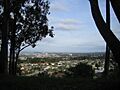
A view of Millbrae from Junipero Serra Park.
-
The official seal of the City of Millbrae.
-
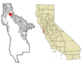
Map showing Millbrae's location in San Mateo County, California.
See also
 In Spanish: Millbrae para niños
