Moel Emoel facts for kids
Quick facts for kids Moel Emoel |
|
|---|---|
 |
|
| Highest point | |
| Elevation | 549 m (1,801 ft) |
| Prominence | 88 m (289 ft) |
| Parent peak | Foel Goch |
| Listing | Dewey |
| Naming | |
| English translation | Bare Hill of Emoel |
| Language of name | Welsh |
| Geography | |
| Location | Gwynedd, Wales |
| Parent range | Arenigs |
| OS grid | SH937402 |
| Topo map | OS Landranger 125 / "Explorer" OL18 |
Moel Emoel is a beautiful hill located in Snowdonia National Park in Gwynedd, North Wales. Its name comes from the Welsh language and means "Bare Hill of Emoel." This hill is a great spot for hiking and enjoying amazing views of the Welsh countryside.
Contents
Exploring Moel Emoel: Location and Views
Moel Emoel is part of the Arenigs mountain range. This range is known for its rugged beauty and peaceful landscapes. Moel Emoel is about 7 miles (11 km) west of Arenig Fawr, another peak in the same range.
What You Can See From Moel Emoel
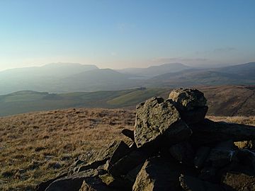
From Moel Emoel, you can easily spot Llyn Celyn, a large lake, nestled between the hills of Arenig Fach and Mynydd Nodol. To the northeast, you'll see Foel Goch, which is about 2 miles (3 km) away. This is considered Moel Emoel's "parent peak" because it's taller and Moel Emoel is part of its wider area.
Looking east, you can see the wide ridge of the Berwyn range, with Cadair Berwyn about 10 miles (16 km) in the distance. On a clear day, the views are truly spectacular!
Amazing Panoramas from the Summit
If you look southwest, you'll see the charming town of Bala, which is only about 3 miles (5 km) away. The view includes the stunning Bala Lake, the impressive Aran Benllyn, and the distant Cadair Idris. The very furthest peak you might be able to see is Tarrenhendre, which is about 28 miles (45 km) away near Abergynolwyn.
Climbing Moel Emoel: Your Adventure to the Top
Hiking to the top of Moel Emoel is a rewarding adventure. The main path starts just outside the town of Bala.
How Long Does the Hike Take?
A round trip to the summit and back usually takes about 3.4 to 4 hours. It's a good hike for those who enjoy spending a few hours exploring the outdoors.
Reaching the Summit
When you reach the very top of Moel Emoel, you'll find a stone cairn. A cairn is a pile of stones built by hikers to mark the highest point of a hill or mountain. It's a great spot to take a break and enjoy the incredible views all around you.

