Mount Mort, Queensland facts for kids
Quick facts for kids Mount MortIpswich, Queensland |
|||||||||||||||
|---|---|---|---|---|---|---|---|---|---|---|---|---|---|---|---|

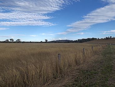
Fields along Grandchester Mount Mort Road, 2015
|
|||||||||||||||
| Population | 78 (2021 census) | ||||||||||||||
| • Density | 0.765/km2 (1.98/sq mi) | ||||||||||||||
| Postcode(s) | 4340 | ||||||||||||||
| Area | 102.0 km2 (39.4 sq mi) | ||||||||||||||
| Time zone | AEST (UTC+10:00) | ||||||||||||||
| Location |
|
||||||||||||||
| LGA(s) | City of Ipswich | ||||||||||||||
| State electorate(s) | Scenic Rim | ||||||||||||||
| Federal Division(s) | Blair | ||||||||||||||
|
|||||||||||||||
Mount Mort is a small country area in the City of Ipswich, Queensland, Australia. It's a quiet place where not many people live. In 2021, only 78 people called Mount Mort home.
Contents
Exploring Mount Mort's Landscape
Mount Mort is known for its interesting natural features, including several hills and a creek.
Mountains and Gaps
Even though the area is called Mount Mort, there isn't actually a mountain with that name! However, there are other cool spots:
- Red Gap (a low point between hills)
- Edwards Gap (another low point)
- Mount Grey (a mountain in the south)
Franklin Vale Creek
A creek called Franklin Vale Creek starts in the southeast of Mount Mort. It flows north through the area and then continues into the nearby town of Grandchester.
High and Low Lands
The western part of Mount Mort is close to the Liverpool Range, where the land can be over 600 meters high. But along Franklin Vale Creek, the land is much lower, usually between 100 and 150 meters.
Beau Brummel Conservation Park
In the west of Mount Mort, you'll find the Beau Brummel Conservation Park. This is a special protected area where nature is kept safe. Outside of this park, most of the land is used for grazing animals like cattle. Some areas also have forests or grow crops.
Main Road
The main road in the area is Grandchester - Mount Mort Road. It comes into Mount Mort from the north (from Grandchester) and goes south through the lower parts of the area, near the creek.
A Glimpse into Mount Mort's Past
Mount Mort has an interesting history, including a name change and an old school.
Early Days and Land Use
Back in 1877, a very large piece of land, about 48,000 acres, was made available for people to settle. This land came from a big farm called the Franklyn Vale pastoral run.
How Mount Mort Got Its Name
The area was first known as Gehrkevale. This name came from Carl Frederick Wilhelm Gehrke, who bought a lot of land there around 1881. But during World War I, many people felt angry towards Germany. Because of this, the name was changed to Mount Mort. It was named after the Mort family, who had settled in the area in 1849.
The Old School
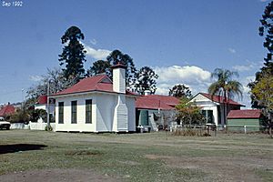
A school called Gehrkevale Provisional School opened on January 18, 1904. It later became Gehrkevale State School. In May 1917, its name was changed to Mount Mort State School, just like the area itself. The school closed for a short time between 1947 and 1949 because there weren't enough students. It closed for good on September 18, 1959. The old school was located at 4 Alpers Road.
Heritage Sites in Mount Mort
Mount Mort has one special place that is listed as a heritage site, meaning it's important to the history of the area.
The Franklyn Vale Homestead is located on Franklin Vale Road. This old homestead is a reminder of the early days of settlement in Mount Mort.
Learning in Mount Mort
There are no schools directly in Mount Mort today. Students living here usually travel to nearby towns for their education.
Primary Schools
For younger students, the closest government primary schools are Grandchester State School in Grandchester (to the north) and Warrill View State School in Warrill View (to the east).
Secondary Schools
Older students attend secondary schools in other towns. The nearest government high schools are Laidley State High School in Laidley (to the north-west) and Rosewood State High School in Rosewood (to the north-east).
 | Percy Lavon Julian |
 | Katherine Johnson |
 | George Washington Carver |
 | Annie Easley |


