Mount Walker West, Queensland facts for kids
Quick facts for kids Mount Walker WestQueensland |
|||||||||||||||
|---|---|---|---|---|---|---|---|---|---|---|---|---|---|---|---|

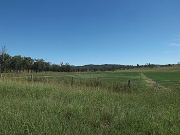
Fields along Mount Walker West Road, 2015
|
|||||||||||||||
| Population | 31 (2021 census) | ||||||||||||||
| • Density | 1.676/km2 (4.34/sq mi) | ||||||||||||||
| Postcode(s) | 4340 | ||||||||||||||
| Area | 18.5 km2 (7.1 sq mi) | ||||||||||||||
| Time zone | AEST (UTC+10:00) | ||||||||||||||
| Location |
|
||||||||||||||
| LGA(s) |
|
||||||||||||||
| State electorate(s) | Scenic Rim | ||||||||||||||
| Federal Division(s) | |||||||||||||||
|
|||||||||||||||
Mount Walker West is a small area, or 'locality', in Queensland, Australia. It's special because it's split between two different local government areas: the Scenic Rim Region and the City of Ipswich. In 2021, only 31 people lived here, making it a very quiet place.
Contents
Geography
Where is Mount Walker West?
Mount Walker West is located in a part of Queensland called South East Queensland. A big river, the Bremer River, forms its eastern border.
Land and Elevation
The land in Mount Walker West changes a lot. Near the Bremer River in the east, it's quite low, about 60 meters (about 197 feet) above sea level. But as you go west, the land gets much higher, reaching up to 260 meters (about 853 feet).
What is the Land Used For?
People in Mount Walker West use the land for different things. Some areas are used for grazing, which means animals like cattle eat the native plants. Other parts are used for growing crops, and some land is used for plantation forestry, where trees are grown specifically to be harvested for wood.
History
How Mount Walker West Got Its Name
The name Mount Walker West comes from a nearby mountain called Mount Walker. This mountain was first named Mount Forbes in 1824 by John Oxley, a famous explorer. He named it after Sir Francis Forbes, who was a very important judge in New South Wales at the time.
Later, the name was changed to Mount Walker. This was to honor a shepherd named Walker, who worked on a large farm called the Franklyn Vale pastoral run.
Population
How Many People Live Here?
Mount Walker West is a very small community.
- In 2016, there were 19 people living in Mount Walker West.
- By 2021, the population had grown slightly to 31 people.
Education
Schools Near Mount Walker West
There are no schools directly in Mount Walker West. Students usually travel to nearby towns for their education.
- For primary school, the closest government schools are Warrill View State School in Warrill View (to the south-east) and Mutdapilly State School in Mutdapilly (to the east).
- For high school, the nearest government secondary school is Rosewood State High School in Rosewood (to the north-east).
 | Janet Taylor Pickett |
 | Synthia Saint James |
 | Howardena Pindell |
 | Faith Ringgold |


