
National Register of Historic Places listings in Park County, Wyoming facts for kids

Welcome to Park County, Wyoming! This amazing area is home to many special places that are listed on the National Register of Historic Places. Think of this register as a super important list of buildings, sites, and objects that tell us a lot about American history and culture. When a place is on this list, it means it's worth protecting and remembering for future generations.
Park County has 41 of these special places. Six of them are even more important and are called National Historic Landmarks. These landmarks are recognized as having national importance, meaning they are significant to the history of the entire United States! Let's explore some of these cool historic spots in Park County.
| Albany - Big Horn - Campbell - Carbon - Converse - Crook - Fremont - Goshen - Hot Springs - Johnson - Laramie - Lincoln - Natrona - Niobrara - Park - Platte - Sheridan - Sublette - Sweetwater - Teton - Uinta - Washakie - Weston |
Contents
- Historic Places in Park County
- Lodges and Retreats
- Buffalo Bill Cody's Legacy
- Yellowstone National Park Sites
- Other Important Sites
- Clay Butte Lookout
- Colter's Hell
- First National Bank of Meeteetse
- Hayden Arch Bridge
- Heart Mountain Relocation Center
- Horner Site
- Mummy Cave
- Pioneer School
- Ralston Community Clubhouse
- Red Lodge-Cooke City Approach Road Historic District
- T E Ranch Headquarters
- US Post Office-Powell Main
- Wapiti Ranger Station
- Images for kids
Historic Places in Park County
Park County is full of interesting places that have been around for a long time. These spots help us understand the past and how people lived, worked, and explored this part of Wyoming.
Lodges and Retreats
Many historic lodges in Park County offered places for travelers to stay, especially those visiting Yellowstone National Park.
Absaroka Mountain Lodge
The Absaroka Mountain Lodge, located near Cody, is a historic group of buildings. It was added to the National Register in 2003. Imagine staying in a cozy lodge surrounded by beautiful mountains!

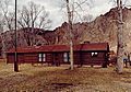
Anderson Lodge
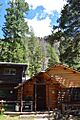
The Anderson Lodge is found in the Greybull Ranger District of the Shoshone National Forest, near Meeteetse. This lodge has been a part of the forest's history since 1987.

Elephant Head Lodge
Another historic lodge near Cody is the Elephant Head Lodge. It was also listed in 2003, showing its importance as a place for visitors to the area.
Goff Creek Lodge
Goff Creek Lodge, also close to Cody, joined the National Register in 2003. These lodges often have a rustic charm that takes you back in time.
Pahaska Tepee
Just two miles east of the eastern entrance to Yellowstone National Park, you'll find Pahaska Tepee. This historic spot was listed in 1973. It's a great example of early tourist accommodations near the park.

Red Star Lodge and Sawmill
The Red Star Lodge and Sawmill, located on Yellowstone Highway near Cody, was added to the register in 2003. This site likely played a role in both lodging and the timber industry of the past.
Roosevelt Lodge Historic District
Inside Yellowstone National Park, the Roosevelt Lodge Historic District is a collection of buildings that tell the story of early tourism in the park. It was listed in 1983 and is a popular spot for visitors today.

UXU Ranch
The UXU Ranch, located in the Shoshone National Forest near Wapiti, became a historic district in 2003. Ranches like this were important for the region's economy and way of life.
Buffalo Bill Cody's Legacy
William F. "Buffalo Bill" Cody was a famous American soldier, bison hunter, and showman. He had a big impact on the town of Cody, which is named after him.
Buffalo Bill Boyhood Home
The Buffalo Bill Boyhood Home, located in Cody, was listed in 1975. This house gives us a peek into the early life of this legendary figure.
,_Le_Claire,_Scott,_IA.jpg)
Buffalo Bill Dam
Just seven miles west of Cody, you'll find the impressive Buffalo Bill Dam. This dam, built in 1910, was a huge engineering feat for its time. It was listed in 1971 and is still an important part of the area's water system.

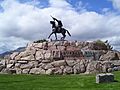
Buffalo Bill Statue
A statue called "Buffalo Bill - The Scout" stands proudly in Cody. This statue, listed in 1974, honors Buffalo Bill and his contributions to the American West.

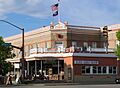
Irma Hotel
The Irma Hotel, located on Sheridan Avenue in Cody, was built by Buffalo Bill Cody himself and named after his daughter. It opened in 1902 and is still a popular hotel today. It was listed in 1973.

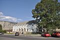
Downtown Cody Historic District
The Downtown Cody Historic District, which includes the Irma Hotel, was listed in 1983. This district preserves the historic buildings and feel of Cody's main street.

Paul Stock House
The Paul Stock House, a beautiful home in Cody, was added to the National Register in 2000. It represents the grand homes built in the area by important figures.

Stock Center
The Stock Center in Cody was listed in 1976. This building likely played a role in the business and community life of the town.

Yellowstone National Park Sites
Several historic places in Park County are actually inside or very close to Yellowstone National Park, the world's first national park!
Fort Yellowstone
Fort Yellowstone, located near Mammoth Hot Springs, is a National Historic Landmark. It was listed in 2003. This fort was originally built by the U.S. Army to protect Yellowstone National Park before the National Park Service was created.

Grand Loop Road Historic District
The Grand Loop Road Historic District covers the main road that circles through Yellowstone National Park. This road, listed in 2003, was carefully designed to allow visitors to see the park's amazing sights.

Lamar Buffalo Ranch
The Lamar Buffalo Ranch, east of Mammoth Hot Springs, was listed in 1982. This ranch was important for helping to bring bison back from near extinction in Yellowstone.

Mammoth Hot Springs Historic District
The Mammoth Hot Springs Historic District, listed in 2002, includes many of the buildings and features around the famous hot springs in Yellowstone. It's a key administrative and visitor area in the park.

Norris Geyser Basin Museum
The Norris Geyser Basin Museum, located on the Grand Loop Road in Yellowstone, was listed in 1983. This museum helps visitors learn about the unique geothermal features of the Norris Geyser Basin.

Norris, Madison, and Fishing Bridge Museums
This group of museums, including Norris, Madison, and Fishing Bridge, are all National Historic Landmarks within Yellowstone National Park. Listed in 1987, they are important examples of early park architecture and education.

North Entrance Road Historic District
The North Entrance Road Historic District, listed in 2002, covers the historic entrance road into Yellowstone National Park. It's the main way many visitors enter the park from the north.

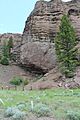
Obsidian Cliff
Obsidian Cliff, a National Historic Landmark listed in 1996, is a unique geological feature in Yellowstone. It's a cliff made of obsidian, a type of volcanic glass. Native Americans used this obsidian for thousands of years to make tools.

Obsidian Cliff Kiosk
Near Obsidian Cliff, the Obsidian Cliff Kiosk was listed in 1982. This small structure helps visitors learn about the history and geology of the area.

US Post Office-Yellowstone Main
The main post office in Yellowstone National Park, located at Mammoth Hot Springs, was listed in 1987. Even in a national park, people needed to send and receive mail!

Other Important Sites
Park County has many other historic sites that tell different stories about its past.
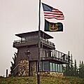
Clay Butte Lookout
The Clay Butte Lookout, near Clark, is a fire lookout tower built between 1941 and 1943. It was started by the Civilian Conservation Corps, a program that put young men to work during the Great Depression. It was listed in 2014.

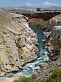
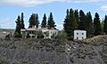
Colter's Hell
West of Cody, you'll find Colter's Hell, a unique area of steam vents and hot springs. When John Colter saw it in 1807, it had active geysers. His account was the first description by a white person of a place in Wyoming. It was listed in 1973.

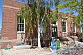
First National Bank of Meeteetse
The First National Bank of Meeteetse, located in Meeteetse, was listed in 1990. This building shows the importance of banks in the development of towns in the American West.

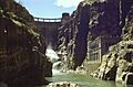
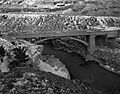
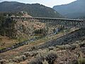
Hayden Arch Bridge
The Hayden Arch Bridge, near Cody, was listed in 1985. This bridge is an example of early 20th-century bridge design and construction.

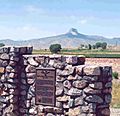
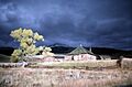
Heart Mountain Relocation Center
The Heart Mountain Relocation Center, near Ralston, is a National Historic Landmark. It was listed in 1985. During World War II, this site was a camp where Japanese Americans were forced to live. It's an important, though sad, part of American history.

Horner Site
The Horner Site, east of Cody, is a National Historic Landmark listed in 1966. This archaeological site provides important clues about early human life in North America.
Mummy Cave
Mummy Cave, near the eastern entrance of Yellowstone National Park, was listed in 1981. This cave is an archaeological site that has revealed artifacts and human remains, including a mummy, that tell us about ancient cultures in the region.

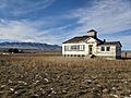
Pioneer School
The Pioneer School, north of Badger Basin near Clark, was listed in 1993. This old schoolhouse reminds us of how education was provided in rural areas long ago.

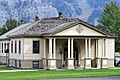
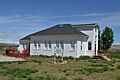
Ralston Community Clubhouse
The Ralston Community Clubhouse in Ralston was listed in 1998. Community clubhouses were often central to social life in small towns.

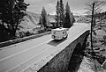
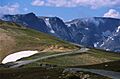
Red Lodge-Cooke City Approach Road Historic District
This historic district covers part of US 212, also known as the Beartooth Highway. It was listed in 2014 and is famous for its stunning mountain views and challenging engineering.

T E Ranch Headquarters
The T E Ranch Headquarters, southwest of Cody, was listed in 1973. This ranch was once owned by Buffalo Bill Cody and was a working ranch that played a role in the area's cattle industry.
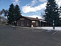
US Post Office-Powell Main
The main post office in Powell was listed in 1987. Like other historic post offices, it represents an important government service in the community.

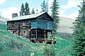
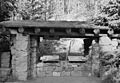
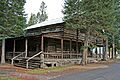
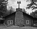
Wapiti Ranger Station
The Wapiti Ranger Station, located in the Shoshone National Forest near Wapiti, is a National Historic Landmark. It was listed in 1966. This was the first ranger station built in the United States, making it a very important site for the history of forest management.

Images for kids
-
The historic buildings of Absaroka Mountain Lodge.
-
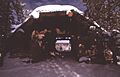
A view of the Anderson Lodge in the forest.
-
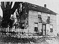
Buffalo Bill's boyhood home.
-
The mighty Buffalo Bill Dam.
-
The "Buffalo Bill - The Scout" statue.
-
The Clay Butte Fire Lookout tower.
-
Colter's Hell, a geothermal area.
-
The Irma Hotel, part of the Downtown Cody Historic District.
-
A building at Fort Yellowstone.
-
A bridge along the Grand Loop Road in Yellowstone.
-
The Hayden Arch Bridge.
-
A marker at the Heart Mountain Relocation Center.
-
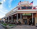
The historic Irma Hotel in Cody.
-
The Lamar Buffalo Ranch in Yellowstone.
-
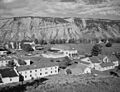
Buildings in the Mammoth Hot Springs Historic District.
-
Mummy Cave.
-
The Norris Museum in winter.
-

Inside the Fishing Bridge Museum.
-
A bridge on the North Entrance Road.
-
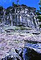
Obsidian Cliff in Yellowstone.
-
The Obsidian Cliff Kiosk.
-
Pahaska Tepee, a historic lodge near Yellowstone.
-
The historic Pioneer School.
-
The Ralston Community Clubhouse.
-
The scenic Beartooth Highway.
-
A close-up of the Roosevelt Lodge.
-
The Stock Center building.
-
The Paul Stock House.
-
The Powell Main Post Office.
-
The Yellowstone National Park Post Office.
-
The historic Wapiti Ranger Station.
