Noel Park facts for kids
Quick facts for kids Noel Park |
|
|---|---|
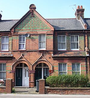
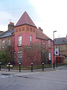
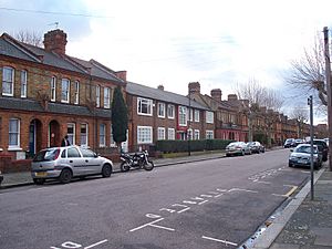
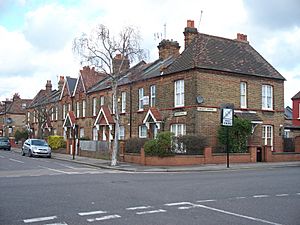 Fourth-class houses in Darwin Road, built during the initial development of Noel Park in the 1880s |
|
| Population | 5,670 |
| OS grid reference | TQ315902 |
| • Charing Cross | 6.4 mi (10.3 km) SSW |
| London borough | |
| Ceremonial county | Greater London |
| Region | |
| Country | England |
| Sovereign state | United Kingdom |
| Post town | LONDON |
| Postcode district | N22 |
| Dialling code | 020 |
| Police | Metropolitan |
| Fire | London |
| Ambulance | London |
| EU Parliament | London |
| UK Parliament |
|
| London Assembly |
|
Noel Park in north London is a special neighbourhood. It was built a long time ago, between the late 1800s and early 1900s. It has about 2,200 homes, all designed by an architect named Rowland Plumbe.
Noel Park was created as a new community on the edge of north London. It was part of the fast-growing area of Wood Green. A company called the Artizans, Labourers & General Dwellings Company (Artizans Company) built it. This company built four similar communities around London. For a few years, a small park nearby was also called Noel Park, but now it's known as Russell Park again.
This estate was one of the first "garden suburbs" in the world. It was made to offer homes that people could afford, especially for working families who wanted to move out of the busy city centre. Every house had its own front and back garden. It was planned to be a complete community. It was also close to train lines, so people could easily travel to work. The company's founder, William Austin, believed in healthy living. Because of this, no pubs were built in Noel Park, and there still aren't any today!
As London grew bigger in the early 1900s, Noel Park became surrounded by other new buildings. In 1932, the area got connected to the London Underground train system. In 1965, Noel Park became part of the new London Borough of Haringey. Then, in 1966, the local council bought the estate, so it became publicly owned.
Noel Park was damaged a bit during the Second World War. Some parts were also knocked down when the Wood Green Shopping City was built in the 1970s. But most of Noel Park still looks like it did when it was first built. In 1982, a large part of the area was made a Conservation Area. This means it's a special place that needs to be protected because of its history and unique design. It's important for understanding how suburbs and housing estates developed.
Contents
Where is Noel Park?
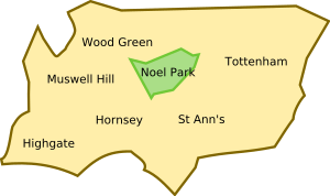
Noel Park is a neighbourhood within Wood Green. It's about 6.4 miles (10.3 km) north of Charing Cross, which is the centre of London. It's located in the middle of the London Borough of Haringey. The area looks a bit like a triangle.
It's surrounded by main roads:
- The A109 road (Lordship Lane) is to the north.
- The A1080 road (Westbury Avenue) is to the south-east.
- The A105 road (Wood Green High Road) is to the west.
When building started, the River Moselle ran along the northern edge. It was later put into underground pipes (called a culvert). The land above it was then used for building.
The western side used to have a railway line called the Palace Gates Line. This line closed in 1964. Now, a big shopping centre called The Mall Wood Green stands where the railway line used to be.
How Noel Park Was Built
Early Days of the Land
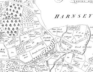
Before the 1800s, most of Wood Green, including where Noel Park is now, didn't have many people. An old map from 1619 shows this area as Duckett's Manor. It was mostly woodland and fields. The only building was Ducketts Farm, which was a very old manor house.
By 1880, this large estate was divided into smaller farms. The northern fields were used for cows, and the southern fields for grazing. A railway line, the Palace Gates Line, was built on the western edge in 1878. It had a station called Green Lanes right next to the future Noel Park site.
The Artizans Company Story
The Artizans, Labourers & General Dwellings Company was started in 1867 by William Austin. He was a very determined person who started as a farm worker and became a successful builder. The company's goal was to build new homes for working-class people. Many homes were being destroyed to make way for railways and other city improvements.
Unlike other companies that built tall apartment blocks in cities, the Artizans Company wanted to build smaller homes in the countryside. These homes would be near train lines so workers could live outside the city and travel to work. A famous leader, Lord Shaftesbury, supported the company.
The company built homes in places like Battersea and Salford. Their first big project was Shaftesbury Park in Battersea, with 1,200 homes. Then they built Queen's Park. There were some problems with money during the Queen's Park project. But by 1880, the company was doing well again and ready to build more.
Choosing the Right Place
In 1881, Rowland Plumbe became the main architect for the Artizans Company. He was a well-known architect who designed hospitals. His job was to plan a new housing estate.
They looked at different places, including one near Alexandra Park in Tottenham. At first, they thought the Wood Green site was too far from people. But they changed their minds. The area had good train connections. The Palace Gates Line had a station right next to the site. This meant people could travel directly to the City of London. Another train station, Wood Green (now Alexandra Palace station), was also nearby.
The company decided that good transport made up for the distance. In June 1881, they bought 100 acres (0.4 km2) of land for a lot of money.
Designing the Homes
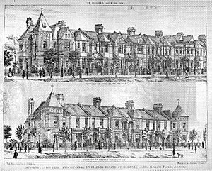
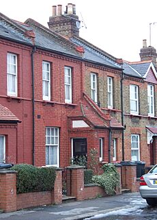
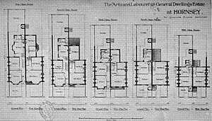
Plumbe designed five different types of houses. Even though they had the same basic shapes, each street looked a bit different. They used different coloured bricks and varied window designs. This gave each street its own special look. All the houses had front and back gardens. Corner houses were designed to stand out, sometimes with small towers.
The bigger houses were built in the middle of the estate, near the church and school. The smaller houses were built on the edges. This was a common way to plan towns back then.
Most houses were built in pairs, sharing a porch. For many smaller houses, the front doors were angled. This meant they didn't open directly next to their neighbours. All houses had at least one living room, a kitchen, a scullery (a small room for washing dishes), and a toilet. The toilets downstairs could only be reached from the back garden. There were no separate bathrooms; people used a movable bath in the kitchen.
All houses had fireplaces with marble surrounds. They also had running water from the New River. However, not all houses had gas or mains electricity at first. Some used candles or oil lamps for light.
The houses were made to be fairly small. This was to keep them affordable and to stop people from taking in too many lodgers. The company wanted each family to have their own space. Some houses were even split into upper and lower flats, each with its own front door.
Building the Estate
In 1883, the Artizans Company sold some land next to the railway. This allowed a special train track (a siding) to be built into the construction site. This meant building materials could be brought in cheaply by train. They even built large workshops to make doors and flooring on site.
There were some problems with tracking building materials. The foreman was found to have made mistakes in the measurements, leading to the company overpaying. He was dismissed, and new checks were put in place.
In 1883, the estate was named "Noel Park" after Ernest Noel. He was a Member of Parliament and the chairman of the Artizans Company. The streets were laid out in a grid plan with wide avenues and narrower roads. Streets were named after important people from the Artizans Company and leading politicians. Some exceptions were Darwin Avenue, named after Charles Darwin, and Moselle Avenue, which followed the path of the underground river.
The Grand Opening
On August 4, 1883, about 200 houses were ready. Noel Park was officially opened. Ernest Noel gave a speech, saying the development would be like a small town. He said it was built to help working-class people live in pleasant surroundings. Lord Shaftesbury also spoke, praising the project. The Archbishop of Canterbury sent a message, saying it was a very important step for the good of working people.
A newspaper reported that Noel Park was "quite a town of artisans' and labourers' dwellings." It noted that "All the streets are wide, and the architecture houses and the agreeable surroundings of trees and fields give them a singularly comfortable and pleasant appearance."
Money Troubles and Growth
Noel Park was advertised as a "Suburban Workman's Colony." They highlighted how easy it was to travel from there. In 1884, the railway company even renamed the local station "Green Lanes (Noel Park)."
However, many working people found train tickets too expensive. There was a debate about offering cheaper "workman's fares." By 1885, both railway companies agreed to offer cheaper tickets for early morning trains. But the delays caused by this argument meant fewer people wanted to move to Noel Park. Many houses were empty, and building slowed down. In 1887, construction stopped for a while.
By 1894, about half of the estate was finished. The southern part of the estate was still open fields.
Community Facilities
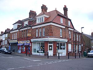
Shops were built around the edges of Noel Park to serve the new residents and people from Wood Green. The shops varied in size and style.
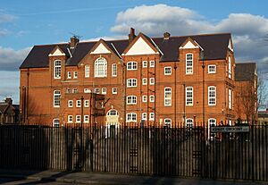
Noel Park School was built in 1889. It was designed by Charles Wall and could hold over 1,500 students. By 1898, the school was very crowded because so many families had moved to Noel Park. Today, it is a primary school for children aged three to 11.
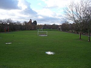
Although there were plans for a park in the middle of the estate, it was never built. Instead, houses were built there. In 1929, a long, narrow piece of land was made into a park called Russell Park. For a short time, it was called Noel Park, but its name has now changed back to Russell Park.
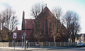
A place for a church was planned from the start. A mission hall opened in 1885, and it quickly became too small. The people of Noel Park raised money for a church, and St Mark's Church was finished in 1889. It's a large church with a unique style.
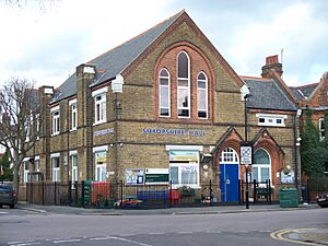
In 1913, a bigger mission hall called the Walsham-How Mission Hall opened. It's now the Noel Park Children's Centre. Because Noel Park was a bit isolated, many clubs and groups formed there.
Remember, the Artizans Company didn't want pubs in Noel Park. This is still true today!
Noel Park in the 20th Century
Growing Bigger in the Early 1900s
By 1905, the Artizans Company planned the rest of the estate. The new houses had a different style, with white brickwork and curved windows. Toilets were now connected to the sculleries. By 1906, nearly 2,000 properties were rented out. Building continued until 1929.
Noel Park and Wood Green were becoming very important in the area. In 1902, the Green Lanes railway station was renamed Noel Park & Wood Green. In 1911, some old houses were knocked down to build the Cheapside shopping area.
The most famous building in Cheapside was the Wood Green Empire. It was a huge theatre that could hold 3,000 people. Many famous performers appeared there. It's also known for a magic trick gone wrong in 1918, where a magician was accidentally shot. The theatre closed in 1955. Today, the building is still there but is used as a shop and offices.
The Piccadilly Line Arrives
In the early 1900s, underground train lines opened in London, but they couldn't extend north to Noel Park because of old agreements. This caused a lot of crowding at Finsbury Park station. People wanted the underground lines to go further north.
In 1929, the government decided to help fund big building projects. So, in 1930, work began to extend the Piccadilly line. New stations opened at Wood Green and Turnpike Lane on September 19, 1932. Both were on the western edge of Noel Park. With fast, clean trains connecting the area to central London, more people moved to Noel Park.
After the War
Noel Park was hit by some V-1 and V-2 bombs during the World War II. In February 1945, a V-2 bomb hit Westbeech Road, causing many deaths and injuries. The damaged areas were rebuilt with new houses in the styles of the time.
In 1958, the old railway goods depot was used for a big exhibition of trains. It was very popular, with about 14,000 visitors.
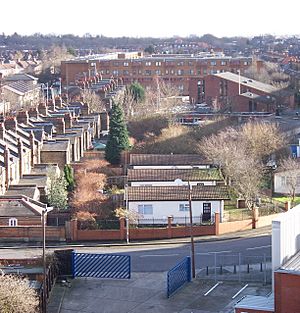
However, the Palace Gates Line was used less and less. Passenger numbers dropped a lot after the Piccadilly line opened. The railway line closed to passengers in 1963 and to freight in 1964. A large apartment building called The Sandlings was built where the goods yard used to be. The Noel Park & Wood Green railway station was knocked down in the 1970s to make way for the Wood Green Shopping City.
Becoming Council Homes
In 1966, the Artizans Company sold Noel Park to the London Borough of Haringey. The 2,175 homes became council housing. This meant the local council owned and managed them.
In 1976, the Artizans Company became part of a larger company called Sun Life.
Noel Park Today
After the council took over, many homes needed repairs. In 1971, a report found that half the homes still didn't have basic things like baths or indoor toilets. So, houses were extended to add modern bathrooms.
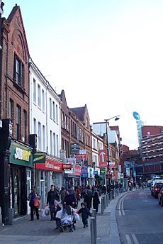
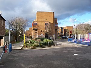
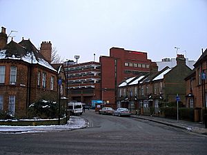
In the early 1970s, the huge Wood Green Shopping City was built. It's a nine-storey complex that now stands out in the area. Some houses were demolished for its construction.
In 1980, new rules allowed council tenants to buy their homes. Because of Noel Park's special architecture and history, a large part of it was made a Conservation Area. This means changes to the outside of the houses need special permission. St Mark's Church was also given special protection.
As with much of Haringey, Noel Park is now a very diverse area, with people from many different backgrounds living there.
Street Names in Noel Park
Many streets in Noel Park are named after important people connected to the Artizans Company or famous politicians of the time:
- Ashley Crescent: Named after Evelyn Ashley, who was Lord Shaftesbury's son and chairman of the Artizans Company.
- Buller Road: Named after Redvers Buller, a brave soldier.
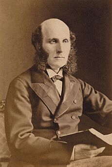
- Darwin Road: Named after Charles Darwin, the famous naturalist. He was also an early investor in the Artizans Company.
- Dovecote Avenue: This street is on the site of the old Duckett's Manor.
- Farrant Avenue: Named after Sir Richard Farrant, a leader in the Artizans Company.
- Gladstone Avenue: Named after William Ewart Gladstone, who was the Prime Minister when Noel Park opened.
- Hewitt Avenue: Named after Thomas Hewitt QC, a director of the Artizans Company.
- Lymington Avenue: Named after Viscount Lymington, another director.
- Mark Road: Named after Mark H Judge, a director of the Artizans Company.
- Maurice Avenue: Named after Maurice Powell, a director of the Artizans Company.
- Morley Avenue: Named after Samuel Morley, a Member of Parliament and director.
- Moselle Avenue: This street runs above the culverted (underground) River Moselle.
- Pelham Road: Named after T W Pelham, a director of the Artizans Company.
- Redvers Road: Also named after Redvers Buller.
- Russell Avenue: Named after John Russell, a former Prime Minister.
- Salisbury Road: Named after Robert Cecil, 3rd Marquess of Salisbury, a leader of the Conservative Party.
- Vincent Road: The reason for this name isn't fully known, but it might be for Rev. Henry Vincent Le Bas.
 | Madam C. J. Walker |
 | Janet Emerson Bashen |
 | Annie Turnbo Malone |
 | Maggie L. Walker |


