
Old Jeffersonville Historic District facts for kids
Quick facts for kids |
|
|
Old Jeffersonville Historic District
|
|

20th-century Masonic temple
|
|

Location in Clark County, Indiana

Location in Indiana

Location in the United States
|
|
| Location | Roughly bounded by Court Ave., Graham St., Ohio River, & I-65, Jeffersonville, Indiana |
|---|---|
| Area | 203 acres (82 ha) |
| Architect | Arthur Loomis, et al. |
| Architectural style | Late 19th And 20th Century Revivals, Bungalow/Craftsman, Late Victorian |
| NRHP reference No. | 87001461 |
| Added to NRHP | October 6, 1987 |

The Old Jeffersonville Historic District is a special area in Jeffersonville, Indiana, United States. It covers the original part of Jeffersonville. Today, it is the heart of downtown Jeffersonville. This historic district was added to the National Register of Historic Places in 1983. This means it is a place worth protecting because of its history.
The district is bordered by Court Avenue to the north and Graham Street to the east. To the south, you'll find the Ohio River, and to the west, Interstate 65. The area is quite large, covering 203 acres (0.8 km2). It includes about 500 buildings, 6 structures, and 11 other historical items. Many banks are located in the old buildings here. A big fire on January 11, 2004, destroyed a block in the district. It burned down the original Horner's Novelty store.
Contents
Exploring Old Jeffersonville's Landmarks
There are many important and interesting buildings in the Old Jeffersonville Historic District.
- At Warder Park, you can see the old Carnegie Library. This library is one of many built across Indiana in the early 1900s.
- Across Spring Street from Warder Park is the Old Masonic Temple. It was built in the early 1900s and has a beautiful marble staircase.
- The local office of Indiana Landmarks helps protect historic places. Their current office is the Willey-Allhands House. It is right next to the historic Grisamore House, which used to be their office.
- Schimpff's Confectionery is a famous candy store. They are known for their red-hots and Modjelskas. Modjelskas are marshmallows covered in caramel.
- Horner's Novelty, a store that sells party supplies and costumes, is also in the district. It was rebuilt after the big fire.
A Look Back: History of Jeffersonville

The first settlement in this area was near the Falls of the Ohio. These falls are the only natural barrier along the entire Ohio River. Because of its location above the falls, Jeffersonville has the deepest harbor nearby. The settlement started in 1786 at Finney, close to where the Big Four Bridge is today. In 1802, Lieutenant Isaac Bowman received 150 acres (0.6 km2) of land here. This was for his service in the American Revolutionary War.
How Jeffersonville Was Planned
Jeffersonville first had three streets that ran along the Ohio River. These were Water Street (which is now gone), Front Street (now Riverside Drive), and Market Street. In 1802, John Gwathemey was asked to plan the land north of Market Street. He used a plan created by Thomas Jefferson. This plan was a bit different from Jefferson's original idea. It included diagonal streets in an open checkerboard pattern.
By 1816, this plan didn't work very well. So, in 1817, the Indiana Legislature ordered the town to be re-planned. In 1836, a civil engineer from Cincinnati was hired to plan the town's expansion to the north. He tried to use Jefferson's original plan again. However, the town council did not accept his plan. They chose a plan from a local engineer instead. Because Cincinnati was a major city then, many mapmakers used the rejected plan. This means most maps of Jeffersonville from 1837 to 1852 were incorrect!
Jeffersonville's Busy Past
From the 1850s until the Great Depression in the 1930s, Jeffersonville was a top spot for building steamboats in the U.S. This was thanks to its great harbor, which was the deepest in the area. Many people who lived in the historic district worked at the Howard Shipyards. This shipyard later became Jeffboat in the nearby town of Port Fulton. Port Fulton eventually became part of Jeffersonville.
The town got its first railroad in 1852, connecting it to Columbus, Indiana. When the Fourteenth Street Bridge opened in 1870, Jeffersonville became an important railroad hub. During the Civil War, the city was a key distribution center for the Union Army. Three railroads connected to Jeffersonville. Also, the Ohio River acted as a defense against attacks from the Confederate side. This made it a safer place than Louisville, Kentucky, which was on the other side of the river.
Most of the buildings you see in the district today were built after 1870. Many commercial buildings on Spring Street show Italianate styles. There are also Gothic Revival churches. These churches reflect the many people who moved here from Ireland and Germany during that time. The homes are often in the American Four Square style, bungalows, or shotgun houses.
Changes Over Time
Until the mid-1950s, the district was a very busy shopping area. It even had a JCPenney department store. But things started to change when the Youngstown Shopping Center was built. This new center was about 1.5 miles (2.4 km) northwest of downtown. The decline continued when Green Tree Mall opened in the 1960s, and J.C. Penney moved there. By the 1980s, more than twenty storefronts were empty. Most of the remaining stores sold antiques, thrift items, or offered repair services.
Main Streets of the District
The Old Jeffersonville Historic District has a main road called Spring Street. It runs from northwest to southeast. From Spring Street, there are five other streets that go from southwest to northeast. Starting from the Ohio River and moving north, these streets are Riverside Drive, Market Street, Chestnut Street, Maple Street, and Court Avenue.
Spring Street
Spring Street is like a typical old commercial street from the 1800s. Most buildings here are in the Italianate or Victorian styles. They are usually two or three stories tall and made of brick. The block closest to the Ohio River (the 100 block) has seen the most changes. It has the Old Strauss Hotel, a three-story Italianate building with arched windows.
The 200 block has many Italianate buildings. A notable one is the old Elk's Club building, which is highly decorated. The 300 block shows more different styles. Here you'll find a 19th-century Masonic Temple and the LaRose Theatre. Horner's Novelty, rebuilt after the big fire, is also here. Schimpff's Confectionery, a candy store that opened in 1891, also has a small candy museum. The 400 block has more Italianate buildings. Its most important building is the 1907 Citizens National Bank Building. It is a stone Classical Revival style with large eagle decorations. This block also has the local office for the Boy Scouts of America. Warder Park is on the east side of the 500 block. It features a Classical Revival Masonic Temple that was used for most of the 1900s.
Riverside Drive
At the southeast end of Spring Street is Riverside Drive. This street offers some of the best views of the Ohio River and the Louisville shoreline. This area hasn't changed as much as other parts of the riverfront. Houseboats are docked along the Ohio River on the south side of Riverside Drive. The north side of the street has a mix of homes and different architectural styles. Unlike other main streets, Riverside Drive is outside the flood-wall that protects most of the city. It was built two feet higher than the water level during the Ohio River flood of 1937.

Market Street
Market Street is mostly residential. The 200 block has many empty areas. But the 300 to 500 blocks have many shotgun houses. As Market Street leaves the district to the east, it becomes Utica Pike. This road connects Jeffersonville with Utica, Indiana, near the Howard Steamboat Museum. North of Market Street, few buildings remain from before 1850. This makes it hard to know what the district looked like in its earliest days.
Chestnut Street
Chestnut Street is also mostly residential. The 200 block of West Chestnut has old supports for the Big Four Bridge. The 100 block of West Chestnut holds the Grisamore House. This house was also added to the National Register of Historic Places in 1983. On East Chestnut, the 100 block has many houses built around 1900. The 200 block is full of bungalows.
St. Augustine Roman Catholic Church is on the 300 block of East Chestnut. It is a Spanish-flavored neo-Baroque building with a Moorish-style rectory. Another church is on the 400 block. This includes the Gothic Revival style First Presbyterian Church. It has pointed windows and a belltower. There is also a school built by the Works Progress Administration. It has a stucco front and metal windows.

Maple Street
Maple Street has more businesses than the other southwest-northeast streets. The 100 block of West Maple Street is mostly parking lots and a funeral home. The Olde Towne Grocery, originally a Kroger store in the 1920s, is on the 100 block of East Maple. Across from it is a collectibles store called Hockeyman's. The 200 block of East Maple Street is mostly homes. It has four large Victorian houses and a big office building used by the Indiana Bell Telephone Company. The 300 to 800 blocks of East Maple are residential. Most of these homes are American Four-Square style. These blocks also have a few Gothic-Revival churches.
Court Avenue
Court Avenue is the northernmost street. Some parts of it are in the historic district, while others are not because of new buildings. Only the 100 West, 100 East, and 700–900 East Blocks of Court Avenue are part of the district. This includes Warder Park and eastern residential areas. However, the current Jeffersonville Township Public Library and the Clark County Courthouse are not in the district. This area was once home to the Falls City Area Center, a college that later moved and became Indiana University Southeast. Warder Park was also the site of an important Civil War bakery. It made hardtack (a type of cracker) for thousands of Union soldiers.
Images for kids
-
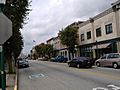
Spring Street of the Historic District
-
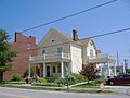
Willey-Allhands House
-
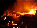
Fire in 2004 that destroyed Horner's


