Ottawa County, Oklahoma facts for kids
Quick facts for kids
Ottawa County
|
|
|---|---|

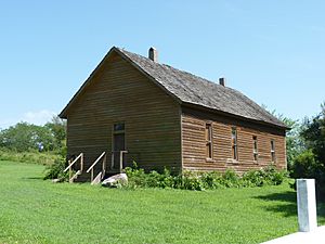
Modoc Mission Church (2010)
|
|

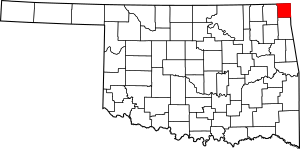
Location within the U.S. state of Oklahoma
|
|
 Oklahoma's location within the U.S. |
|
| Country | |
| State | |
| Founded | 1907 |
| Named for | Ottawa Tribe of Oklahoma |
| Seat | Miami |
| Largest city | Miami |
| Area | |
| • Total | 485 sq mi (1,260 km2) |
| • Land | 471 sq mi (1,220 km2) |
| • Water | 14 sq mi (40 km2) 2.8%% |
| Population
(2020)
|
|
| • Total | 30,285 |
| • Density | 62.44/sq mi (24.109/km2) |
| Congressional district | 2nd |
Ottawa County is a county located in the northeastern part of Oklahoma. In 2020, about 30,285 people lived here. Its main city and county seat is Miami. The county got its name from the Ottawa Tribe of Oklahoma. It is also home to the Modoc Nation and the Quapaw Nation.
Ottawa County is part of the Miami, OK Micropolitan Statistical Area. This area is also included in the larger Joplin-Miami, MO-OK area. The county shares borders with both Kansas and Missouri.
In the early 1900s, the county was important for mining lead and zinc. Later, in 1983, the Tar Creek Superfund site was created. This site helps clean up mining waste and stop pollution in the water.
Contents
History
Early Inhabitants and Tribes
Studies show that people have lived in this area for thousands of years. Different groups of Native Americans lived here long ago. By the 1800s, the Osage Nation had moved into the area. They later gave this land to the U.S. government.
In 1828, the Western Cherokee tribe traded their land in Arkansas for some of the land the Osage had left. Then, in 1831, the U.S. government took back part of this land. They used it to move several other Native American tribes. These tribes had been forced from their homes in the Midwest.
Many tribes were moved here, including two groups of Iroquois, Shawnee, Quapaw, Peoria, Kaskaskia, Miami, Ottawa, and Wyandotte.
Modoc Nation and Other Tribes
In 1873, the Modoc band, led by Captain Jack, was moved here. They were prisoners after a war in California. About 153 Modoc people settled in the area. In 1978, the Modoc Tribe of Oklahoma became a federally recognized tribe again. They were given their own land in this county. Today, Native Americans make up almost 17% of the county's population.
Mining and Environmental Cleanup
This county is part of the Tri-State district. This area was a major center for lead and zinc mining. Mining was very active through the first half of the 1900s. However, this mining caused serious environmental damage.
Places like Picher, Oklahoma in the county became part of the Tar Creek Superfund Site in 1980. This site was set up to clean up the pollution. Because of the pollution, the government decided to close Picher as a city. Most of its residents have moved away since the early 2000s.
Geography
Land and Water
Ottawa County covers about 485 square miles. About 471 square miles are land, and 14 square miles are water. This means about 2.8% of the county is water. It is the fourth-smallest county in Oklahoma by size. The eastern part of the county is in the Ozark Plains. The western part is in the Neosho Lowlands.
Neighboring Counties
Ottawa County shares borders with these counties:
- Cherokee County, Kansas (north)
- Newton County, Missouri (east)
- McDonald County, Missouri (southeast)
- Delaware County (south)
- Craig County (west)
Demographics
| Historical population | |||
|---|---|---|---|
| Census | Pop. | %± | |
| 1910 | 15,713 | — | |
| 1920 | 41,108 | 161.6% | |
| 1930 | 38,542 | −6.2% | |
| 1940 | 35,849 | −7.0% | |
| 1950 | 32,218 | −10.1% | |
| 1960 | 28,301 | −12.2% | |
| 1970 | 29,800 | 5.3% | |
| 1980 | 32,870 | 10.3% | |
| 1990 | 30,561 | −7.0% | |
| 2000 | 33,194 | 8.6% | |
| 2010 | 31,848 | −4.1% | |
| 2020 | 30,285 | −4.9% | |
| 2021 (est.) | 30,340 | −4.7% | |
| U.S. Decennial Census 1790–1960 1900–1990 1990–2000 2010–2019 |
|||
In 2020, there were 30,285 people living in Ottawa County. There were 12,984 households. The population density was about 175 people per square mile.
The racial makeup of the county was mostly White (68.9%), Native American (20.3%), and Black or African American (1.2%). About 5.9% of the population was Hispanic or Latino.
The population was spread out by age. About 25.7% were under 18 years old. About 16.9% were 65 years or older. The average age in the county was 37 years.
Economy
Mining History and Cleanup
Lead and zinc mining has been important to Ottawa County since 1890. At its peak in 1926, Ottawa County was the world's largest source of lead and zinc. Most mines closed by the 1960s. They left behind mine shafts, sinkholes, and piles of mining waste.
These areas are now part of the Tar Creek Superfund Site. The US Environmental Protection Agency works to clean up these dangerous areas. Another mineral called Tripoli, used for cleaning, was also mined here for a long time.
Tourism Today
Today, Ottawa County and nearby Delaware County are big tourist spots in Oklahoma. Together, they are the third-largest tourism destination in the state. Only Oklahoma City and Tulsa attract more tourists.
Communities
City
- Miami (county seat)
Towns
Census-designated places
Unincorporated communities
Ghost towns
Education
Ottawa County has several school districts:
- Afton Public Schools
- Commerce Public Schools
- Fairland Public Schools
- Miami Public Schools
- Quapaw Public Schools
- Welch Public Schools
- Wyandotte Public Schools
- Turkey Ford Public School (elementary only)
The Picher-Cardin Public Schools operated until 2009.
National Register of Historic Places Sites
Many important historical places in Ottawa County are listed on the National Register of Historic Places. These include:
- Cities Service Station, Afton
- Coleman Theatre, Miami
- George L. Coleman Sr. House, Miami
- Commerce Building/Hancock Building, Miami
- Dobson Family House, Miami
- Horse Creek Bridge, Afton
- John Patrick McNaughton Barn, Quapaw
- Miami Downtown Historic District, Miami
- Miami Marathon Oil Company Service Station, Miami
- Miami Original Nine-Foot Section of Route 66 Roadbed, Miami
- Modoc Mission Church and Cemetery, Miami
- Narcissa D-X Gas Station, Miami
- Nine Tribes Tower, Miami
- Ottawa County Courthouse, Miami
- Peoria Indian School, Miami
- Peoria Tribal Cemetery, Miami
- Riviera Courts--Motel, Miami
- Tri-State Zinc and Lead Ore Producers Association Office, Picher
- Isaiah Walker House, Wyandotte
See also
 In Spanish: Condado de Ottawa (Oklahoma) para niños


