Papakating Creek facts for kids
Quick facts for kids Papakating Creek |
|
|---|---|
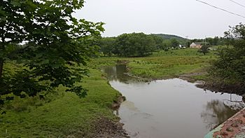
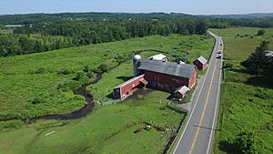
Looking south from County Route 565 in Wantage Township
|
|
| Other name(s) | Pepper-Cotton, Pellettown Creek, Pellet Creek |
| Country | United States |
| State | New Jersey |
| County | Sussex |
| Municipality | Frankford Township, Wantage Township |
| Physical characteristics | |
| Main source | Frankford Township, at foot of Kittatinny Mountain 900 ft (270 m) 41°12′36″N 74°43′02″W / 41.21000°N 74.71722°W |
| River mouth | Wallkill River, E of Sussex borough 387 ft (118 m) 41°12′05″N 74°34′35″W / 41.20139°N 74.57639°W |
| Length | 20.1 mi (32.3 km) |
| Basin features | |
| River system | Wallkill River (tributary of Rondout Creek, Hudson River) |
| Basin size | 60.6 sq mi (157 km2) |
| Tributaries |
|
Papakating Creek is a stream about 20.1-mile-long (32.3 km) in New Jersey. It flows through Frankford and Wantage in Sussex County. The creek starts in a small swamp at the base of Kittatinny Mountain. Its waters eventually join the Wallkill River east of Sussex borough.
Papakating Creek and its main branches drain the northern part of New Jersey's Kittatinny Valley. This valley has rich farmland and forests. The land was shaped by glaciers from the last ice age. Most of the area around the creek is rural, with farms, forests, and a few small towns. The New Jersey Department of Environmental Protection says the creek has some pollution. This comes from farm runoff, homes, and natural minerals. The area also includes parts of state parks, a federal wildlife refuge, and nature preserves. These places protect wildlife and special ecosystems.
Contents
History and Name of Papakating Creek
The name Papakating was officially approved for this creek in 1897. It comes from the language of the Munsee people. The Munsee were a group of Lenape (also called Delaware Indians) who lived in northern New Jersey and nearby areas.
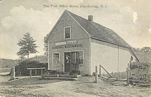
The name Papakating has been used for the creek since colonial times. Old maps from the time of the American Revolution sometimes spelled it Pepocottin or Pepper-Cotton. The name was used for both the creek and its valley. Later, in the 1800s, a small village, a post office, and a train station were also called Papakating. The post office opened in 1851 as "Pepokating" and changed to Papakating in 1862. It closed in 1923.
Today, a place where a small stream joins Papakating Creek is called Pellettown. The creek was also briefly known as Pellet Creek or Pellettown Creek. These names came from William Pellet, Jr. and Obadiah Pellet. They bought land and settled along the Papakating in 1801. Obadiah Pellet built a house, a mill, a blacksmith shop, and a store by 1812. This area became known as Pellettown.
Where Papakating Creek Flows
The Papakating Creek starts about 900 feet (270 m) above sea level in Frankford Township. It begins in a small swamp at the foot of Kittatinny Mountain. This spot is near Sunrise Mountain.
From its start, the creek flows southeast through Frankford Township. It passes north of Branchville. The Papakating then turns northeast. It flows through areas like Armstrong and Pellettown in Frankford. The stream winds through many miles of farmland in the Kittatinny Valley. At Pellettown, it is joined by another stream and goes under County Route 565. This road runs mostly parallel to the creek. An old railroad line also follows the creek's east bank.
Near Sussex borough, at McCoy's Corner, the Papakating Creek meets its branch called West Branch Papakating Creek. The creek continues northeast past Sussex Airport. At Lewisburg, two more streams, Neepaulakating Creek and Clove Brook, join the Papakating. The creek then turns eastward and goes under New Jersey Route 23. It flows into a large marshy area before joining the Wallkill River east of Sussex borough.
Papakating Creek's Watershed
The Papakating Creek's watershed is the area of land that drains into it. This area covers about 60.6 square miles (157 km2). It includes parts of Frankford, Lafayette, Montague, and Wantage Townships. It also includes all of Sussex Borough.
The watershed has gently sloping farm fields, forests, and wetlands. There are also some homes. The land slopes gently in the east and more steeply in the west. The water from this watershed flows into the Wallkill River. The Wallkill River then flows north to join Rondout Creek, which then flows into the Hudson River.
About 27.7% of the watershed is farmland. Forests cover about 42.4%, and wetlands make up 15.4%. About 12.4% is developed with homes. In 2002, about 11,602 people lived in this watershed.
The Papakating Creek watershed is bordered by Kittatinny Mountain to the west. To the east is the Wallkill River watershed. The Kittatinny Valley has dark shale and limestone rock. Its soils were left behind by glaciers. The valley is part of the Great Appalachian Valley, a long valley stretching from Canada to Alabama.
A special feature in the watershed is Rutan Hill. This hill is thought to be the remains of an ancient, inactive volcano. It was active about 420 million years ago.
Water Quality and Pollution
In 2004, the New Jersey Department of Environmental Protection said that a part of Papakating Creek near Sussex Borough was polluted. It had too much phosphorus. This pollution mostly comes from fertilizer used on lawns and farms. Large groups of geese near the lakes also add phosphorus to the creek. Too much phosphorus can cause too many algae and plants to grow in the water. This can harm the animals and plants that live there.
The creek also has some fecal coliform bacteria and arsenic. Fecal coliform can come from septic systems, farm animals, and wildlife. Arsenic might come from natural minerals in the ground or from old farm pesticides.
Streams Joining Papakating Creek
| Tributary | Photograph | Length | Source location | Source elevation | Mouth location | Mouth elevation | Notes |
|---|---|---|---|---|---|---|---|
| Unnamed tributary | – | – | 1 mile W of Beemerville 41°12′57″N 74°42′35″W / 41.215827°N 74.709822°W |
960 feet (290 m) | at Pellettown, Frankford Township 41°09′37″N 74°40′48″W / 41.160248°N 74.679862°W |
430 feet (130 m) | |
| Unnamed tributary (draining Lake Windsor) |
– | – | S of Lake Winsdor in Lafayette Township 41°09′27″N 74°38′19″W / 41.157560°N 74.638647°W |
540 feet (160 m) | 1 mile S of McCoys' Corner 41°10′40″N 74°38′23″W / 41.177731°N 74.639807°W |
410 feet (120 m) | |
| West Branch Papakating Creek |  |
– | 1 mile N of Beemerville 41°13′30″N 74°41′54″W / 41.2250818°N 74.6982336°W |
960 feet (290 m) | 0.6 miles S of McCoy's Corner, Wantage Township 41°11′17″N 74°37′57″W / 41.1881557°N 74.6324565°W |
397 feet (121 m) | |
| Neepaulakating Creek |  |
2.4 miles (3.9 km) | 0.4 miles NW of Lake Neepaulin41°13′23″N 74°38′02″W / 41.223151°N 74.6337733°W | 640 feet (200 m) | at Lewisburg, Wantage Township 41°11′57″N 74°36′40″W / 41.1990769°N 74.6112294°W |
394 feet (120 m) | |
| Clove Brook | – | 12.0 miles (19.3 km) | 1.2 miles E of High Point 41°19′19″N 74°38′12″W / 41.3220388°N 74.6365509°W |
980 feet (300 m) | at Lewisburg, Wantage Township 41°11′57″N 74°36′37″W / 41.1991698°N 74.6102330°W |
394 feet (120 m) |
Climate in the Papakating Creek Area
The Papakating Creek watershed is in a higher part of northwestern New Jersey. This means it has a cooler climate. It gets a good amount of rain and snow throughout the year. The average temperature is above 10 °C (50 °F) for at least four months. This is different from most of New Jersey, which has warmer winters.
The area gets sunshine about 62% of the time in summer and 48% in winter. Winds usually come from the southwest. However, in late winter and early spring, they come from the northwest. The Kittatinny Valley, where the creek is, gets more snow than other parts of northern New Jersey. This is because of Kittatinny Mountain. The mountain makes the air more humid and causes more snow to fall.
The average daily temperature ranges from 25.0 °F (−3.9 °C) in January to 71.1 °F (21.7 °C) in July. Temperatures can reach 90 °F (32 °C) about 12 days a year. They can drop to 0 °F (−18 °C) about 6 nights a year. Snowfall averages about 42 inches (107 cm) per season, but this can change a lot each year. The coldest temperature ever recorded was −29 °F (−34 °C) in 1994. The hottest was 106 °F (41 °C) in 1936.
| Climate data for Sussex, New Jersey (1981–2010 normals) | |||||||||||||
|---|---|---|---|---|---|---|---|---|---|---|---|---|---|
| Month | Jan | Feb | Mar | Apr | May | Jun | Jul | Aug | Sep | Oct | Nov | Dec | Year |
| Record high °F (°C) | 71 (22) |
73 (23) |
90 (32) |
95 (35) |
97 (36) |
98 (37) |
106 (41) |
102 (39) |
102 (39) |
92 (33) |
84 (29) |
75 (24) |
106 (41) |
| Mean daily maximum °F (°C) | 34.1 (1.2) |
37.9 (3.3) |
46.8 (8.2) |
58.9 (14.9) |
69.8 (21.0) |
77.8 (25.4) |
82.3 (27.9) |
80.8 (27.1) |
73.1 (22.8) |
62.2 (16.8) |
50.9 (10.5) |
38.7 (3.7) |
59.4 (15.2) |
| Mean daily minimum °F (°C) | 15.8 (−9.0) |
17.9 (−7.8) |
25.7 (−3.5) |
36.1 (2.3) |
45.4 (7.4) |
55.1 (12.8) |
60.0 (15.6) |
58.0 (14.4) |
50.1 (10.1) |
38.4 (3.6) |
31.0 (−0.6) |
21.6 (−5.8) |
37.9 (3.3) |
| Record low °F (°C) | −29 (−34) |
−23 (−31) |
−10 (−23) |
9 (−13) |
24 (−4) |
33 (1) |
40 (4) |
34 (1) |
27 (−3) |
13 (−11) |
6 (−14) |
−13 (−25) |
−29 (−34) |
| Average precipitation inches (mm) | 3.19 (81) |
2.83 (72) |
3.69 (94) |
4.27 (108) |
4.10 (104) |
4.41 (112) |
4.02 (102) |
4.18 (106) |
4.23 (107) |
4.52 (115) |
3.47 (88) |
3.74 (95) |
46.65 (1,184) |
| Average snowfall inches (cm) | 13.8 (35) |
9.4 (24) |
6.5 (17) |
2.0 (5.1) |
0 (0) |
0 (0) |
0 (0) |
0 (0) |
0 (0) |
0 (0) |
1.3 (3.3) |
9.2 (23) |
42.2 (107.4) |
| Average precipitation days (≥ 0.01 in) | 10.6 | 8.6 | 11.1 | 12.4 | 12.6 | 11.0 | 10.9 | 10.7 | 9.1 | 10.1 | 9.9 | 10.7 | 127.7 |
| Average snowy days (≥ 0.1 in) | 5.4 | 3.7 | 2.6 | .5 | 0 | 0 | 0 | 0 | 0 | .1 | .6 | 3.2 | 16.1 |
| Source: NOAA (extremes 1893–present) | |||||||||||||
Wildlife and Protecting the Papakating Creek
Many parts of the Papakating watershed are protected areas. These are managed by state and federal governments. Some lands along Kittatinny Mountain are in High Point State Park and Stokes State Forest. The area where Papakating Creek meets the Wallkill River is part of the Wallkill River National Wildlife Refuge. These protected lands allow for fun activities like fishing, hunting, hiking, and birdwatching. The New Jersey Division of Fish and Wildlife also puts different types of trout (brook, brown, and rainbow) into the creek for people to fish.
The New Jersey Natural Lands Trust says the Papakating Creek watershed has many different homes for plants and animals. Some of these species are rare or endangered.
- Meadows and pastures are like grasslands for songbirds. Hawks hunt there.
- Forests with ash, maple, and hemlock trees keep the slow-moving creek cool and shady. Animals like raccoons, mink, and possums use fallen trees to cross the creek.
- Wood frogs and salamanders live near the edges of smaller wetlands.
- Painted turtles and bluegills swim in the deeper parts of the creek.
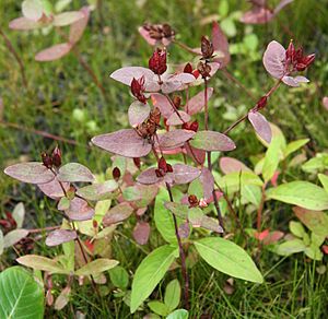
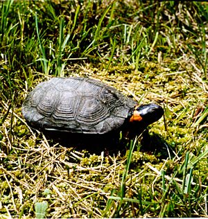
In 2010, a special wetland called Armstrong Bog was bought to protect it. This bog is important for the bog turtle, which is an endangered species. It also protects a rare plant called Fraser's Saint John's wort. The bog is a wet meadow with pinkish-purple flowers in late summer. Other areas near the creek have wetlands with arrowwood and elderberry plants. These provide a good home for wood turtles and yellow-throated warblers.
 | Misty Copeland |
 | Raven Wilkinson |
 | Debra Austin |
 | Aesha Ash |


