
Parc Cwm long cairn facts for kids
|
Welsh: carn hir Parc Cwm
|
|
 |
|
| Location | near Parkmill, Gower |
|---|---|
| Region | City and County of Swansea, Wales |
| Coordinates | 51°35′18″N 4°06′45″W / 51.5883°N 4.1126°W |
| Type | chambered tomb |
| History | |
| Periods | Neolithic |
| Site notes | |
| Condition | nearly intact |
Parc Cwm long cairn (Welsh: carn hir Parc Cwm), also known as Parc le Breos burial chamber, is a very old stone tomb. It was built around 5,850 years ago during the Neolithic period, also called the New Stone Age. This type of tomb is known as a chambered tomb or cromlech.
The tomb is located about 7.5 miles (12 km) west-southwest of Swansea, Wales. It sits in an area now known as Coed y Parc Cwm, within Parc le Breos on the Gower Peninsula.
The tomb is shaped like a trapezoid and was once covered by earth and rubble. It is about 72 feet (22 m) long and 43 feet (13 m) wide at its widest point. A low dry-stone wall holds the stones in place.
A bell-shaped entrance area, called a forecourt, leads into the tomb. Inside, there is a central path lined with large limestone slabs. Human remains were placed in two pairs of stone rooms leading off this path.
The cromlech was found in 1869 by workers digging for road stone. Later that year, archaeologists dug up the site. They found human bones from at least 40 people, animal bones, and Neolithic pottery. Studies show the tomb was used for 300 to 800 years.
Around 6,000 years ago, life in North-West Europe changed a lot. People stopped being hunter-gatherers and started farming. This big change is called the Neolithic Revolution. However, the bones found at Parc Cwm show that the people buried there were still hunter-gatherers or herders.
Parc Cwm long cairn is in what used to be a medieval deer park. This park, called Parc le Breos, was created around 1220 CE. It was a large enclosed area, now mostly farmland. The tomb is in a dry, narrow gorge with about 500 acres (2 km²) of woodland. You can visit the site for free by following a path from the park's entrance. The tomb is cared for by Cadw, the Welsh Government's historic environment group.
Contents
History of the Tomb
After the last ice age ended (about 12,000 to 10,000 years ago), Mesolithic hunter-gatherers began moving north. Wales became free of glaciers around 10,250 years ago. At that time, sea levels were much lower. Areas that are now under the North Sea were dry land, connecting Britain to Europe.
As sea levels rose, Wales became an island. By the start of the Neolithic period (6,000 years ago), the climate was warmer. This led to thick forests growing across Britain.
Around 6,000 years ago, people in North-West Europe changed their way of life. They moved from hunting and gathering to farming and settling down. This change was not developed by people in Britain alone. Farmers from mainland Europe brought new ideas, crops, and animals.
These new farmers cleared forests to grow crops and raise animals. They also brought new skills like making pottery and textiles. They built large stone structures called long barrows or dolmens. These were the first big, permanent buildings made by humans. Building them needed many people, suggesting large communities lived nearby.
Severn-Cotswold Tombs
The tomb at Parc Cwm is one of about 120-130 sites known as Severn-Cotswold tombs. These tombs were often built in places that were already important. These might have been old clearings in the woods that became meeting places.
These tombs were built during the Neolithic period. They share several features:
- They are long and trapezoid-shaped, up to 328 feet (100 m) long.
- They have a cairn, which is a mound of stones built as a memorial.
- They have a strong retaining wall, called a revetment, which also forms a horned entrance area.
- They have huge capstones (large flat stones) supported by upright stones called orthostats.
- They contain stone rooms, or chambers, where human remains were placed. These rooms could be reached through a passageway.
Most Severn-Cotswold tombs are found east of the River Severn in England. However, similar tombs are also found in southeast Wales, including Gower. Parc Cwm long cairn is one of six such tombs found on Gower.
These tombs are the oldest surviving examples of architecture in Great Britain. Parc Cwm long cairn was built about 1,500 to 1,300 years before famous sites like Stonehenge or the Great Pyramid of Giza in Egypt. Besides being burial places, these tombs may have been places where communities gathered. People might have met there to socialize, find partners, trade animals, and exchange gifts.
Features of Parc Cwm Long Cairn

Parc Cwm long cairn is a chambered tomb of the Severn-Cotswold type. It was built around 5,850 years ago. It is about 8 miles (13 km) west of Swansea, Wales. Other names for it include Parc le Breos burial chamber, the Long Cairn, and the Giant's Grave.
The tomb is a long mound of local rocks and pebbles, mostly limestone. It is held in place by two well-built dry-stone walls. The tomb is shaped like a trapezoid, about 72 feet (22 m) long. It is 43 feet (13 m) wide at its southern entrance and narrows to about 20 feet (6 m) at its northern end. Part of the front wall has collapsed, showing some of the stones that were once covered.
At the entrance, the walls curve inward to form a bell-shaped forecourt. A straight central passageway, 21 feet (6.4 m) long and 3 feet (0.9 m) wide, leads into the mound. This passage is lined with thin limestone slabs, standing upright.
Two pairs of rectangular rooms, called transept chambers, lead off the passageway. These rooms are about 5.5 feet (1.6 m) by 3.25 feet (1.0 m). Each room, except one, has low limestone sills at its entrance.
Originally, large capstones would have covered these chambers, protecting the human remains inside. Today, the earth covering and the upper part of the tomb are gone. This leaves the passageway and side chambers open to the sky.
Excavation and Discoveries
Workers found the site in 1869 while digging for road stone. John Lubbock and Hussey Vivian dug there that same year. They found human bones that were "much broken" and not neatly arranged. They also found animal remains, like deer and pig teeth, and pieces of Neolithic pottery.
At first, people thought the bones were from 20-24 individuals. However, more recent studies show there were at least 40 people buried there. After the first dig, most of the human bones were reburied in clay pots. Some bones, along with the animal and pottery remains, are now kept at the Ashmolean Museum in Oxford, England.
In 1937, Professor Glyn Daniel led another dig. He identified the site as a chambered long barrow. More recently, experts have noted that Parc Cwm long cairn is a chambered tomb because it has stone chambers.
At Parc Cwm, different ways of burying the dead were found. In the front, southeast chamber, cremated human remains were found. This chamber held nearly three times as many individuals as the other chambers. It contained bones of both females and males, and people of all ages. The other chambers had remains from all age groups except very young children and babies.
In the entrance area, archaeologists found groups of items. These included flint tools, a leaf-shaped arrowhead, pieces of quartz, and pottery. Some experts believe that bodies might have been left in nearby caves to decompose first. Then, the bones were moved to the tomb. This process is called excarnation.
After a 1960 excavation, the tomb was placed under the care of the government. In 1961, it was partly restored to how it looks today.
Cathole Cave

The Cathole Cave, also known as Cat Hole Cave or Cathole Rock Cave, is a steep limestone cave. It is about 200 yards (180 m) north of the Parc Cwm long cairn. The cave is a deep, triangular crack in the hillside. It has two entrances and a natural platform outside the larger one.
This cave was used as a shelter by Mesolithic hunters. It was also used as a ossuary (a place for bones) during the Neolithic period. The first dig in 1864 found items from the Mesolithic to the medieval periods. Later digs confirmed that Mesolithic hunters used the cave a lot.
In 1984, an excavation found even older items. These included two pointed tools that might be from around 28,000 years ago. This was during an interglacial period, a warmer time between ice ages. These tools are from around the same time as the "Red Lady of Paviland". This "lady" was found in another cave about eight miles (13 km) west of Cathole Cave. Her remains are the oldest known human burial in Great Britain, dated to about 29,000 years ago.
In 2010, Rock art was discovered on the back wall of Cathole Cave. It is an engraving thought to show a reindeer, about 15 x 11 cm in size. This artwork is dated to about 14,505 years ago. It is believed to be the oldest rock art in the British Isles, and possibly in north-western Europe.
Tools from the Late glacial period, around 12,000 years ago, were also found. These include flint blades, scrapers, and a bone needle. Flint is rare in Wales, so these tools must have been brought from other areas. Remains of animals like red fox, Arctic fox, brown bear, and possibly reindeer were found with these tools. This tells us about the climate around 12,000 years ago. Older animal remains, like mammoth and woolly rhinoceros, were also found.
Several items from the Bronze Age were discovered too. These include a bronze axe, two human skeletons, and pieces of pottery from burial urns.
Llethryd Tooth Cave
Another nearby site is the Llethryd Tooth Cave, or Tooth Hole cave. This cave is about 1,500 yards (1.4 km) north-northwest of Parc Cwm long cairn. In 1962, an excavation found the bones of six people there. These remains date to the Early Bronze Age or Beaker culture.
Other items found at Llethryd Tooth Cave include pottery, flint knives, and animal bones. These animal bones were from domesticated animals, including cats and dogs. Experts believe this period of use in the Tooth Cave might be important for understanding the later use of Parc Cwm long cairn.
Location and Access

The Neolithic tomb at Parc le Breos is about 7.5 miles (12 km) west-southwest of Swansea, Wales. It is in the middle of Gower, between the villages of Llanrhidian and Bishopston. The closest village is Parkmill, about one mile (1.5 km) to the southeast.
Parc Cwm long cairn sits in a dry, narrow limestone gorge. It is about 50 feet (15 m) above sea level. The tomb is less than 1.25 miles (2 km) from the south coast of Gower. It is located in about 500 acres (200 ha) of woodland called Coed y Parc. This woodland is what remains of a former medieval deer park called Parc le Breos. The tomb gets its alternative name, Parc le Breos burial chamber, from this park.
The deer park was created by John de Braose, a powerful lord of Gower, around 1221-1232 CE. It was a large enclosed area of about 2,000 acres (800 ha), but now it is mostly farmland. A 19th-century hunting lodge nearby has been turned into a hotel and pony trekking center called Parc le Breos.
Coed y Parc is managed by Natural Resources Wales. The site is open to the public for free. There is parking for 12-15 cars about 750 feet (230 m) away. From the car park, a kissing gate allows access to a flat path. This path runs past the tomb, coming within about 10 feet (3 m) of it. Parc Cwm long cairn is maintained by Cadw (which means "to keep" in Welsh), the Welsh Government's historic environment group.
Images for kids
-
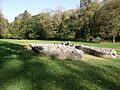
Parc Cwm long cairn from the south west. This view shows the entrance and the surrounding grassy area.
-
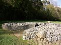
Parc Cwm long cairn forecourt – from the south east. You can see the dry-stone wall and where some rubble has fallen.
-
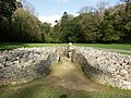
Parc Cwm long cairn from the south. This shows the bell-shaped courtyard at the entrance.


See also
 In Spanish: Parc Cwm para niños
