
List of villages in Gower facts for kids
Quick facts for kids Gower Peninsula |
|
|---|---|
| Principal area | |
| Ceremonial county | |
| Country | Wales |
| Sovereign state | United Kingdom |
| Dialling code | 01792 |
| Police | South Wales |
| Fire | Mid and West Wales |
| Ambulance | Welsh |
| EU Parliament | Wales |
The Gower Peninsula (Welsh: Gŵyr) is a beautiful area in Swansea, Wales. It's home to more than twenty villages and communities. Most of the peninsula is a special place called an Area of Outstanding Natural Beauty, which means its stunning landscapes are protected.
Contents
Exploring Gower's Villages
The Gower Peninsula is famous for its charming villages. Each one has its own unique history and special features, from ancient churches to sandy beaches and interesting landmarks.
Bishopston
Bishopston (Welsh: Llandeilo Ferwallt) is an inland village. It's about 9.5 km west-southwest of Swansea. It's also close to popular beaches like Caswell Bay, Brandy Cove, and Pwll Du. Bishopston is one of the larger villages in Gower. It has its own rugby club, South Gower Rugby Football Club. It also has primary and comprehensive schools.
The village church is dedicated to Saint Teilo. This saint gives the village its Welsh name. The church has a large, simple font from Roman times. Its tower holds two bells from the 1700s. You can also see parts of an old stone cross in the churchyard.
Cheriton

Cheriton is a village near the north coast. Many visitors stay here in summer to explore the local beaches. The church of St Catwg (or Cadoc) was built in the 1200s. It is a very important historical building.
You can follow footpaths from Cheriton. One path goes south-east to Stembridge. Another goes south-west to Llangenydd.
Crofty
Crofty is a small village on the north coast. It's known for its cockling industry. This means people gather cockles, which are small shellfish, from the nearby waters. Crofty is located between Penclawdd and Llanmorlais.
Gowerton
Gowerton (Welsh: Tregŵyr) is an inland village. It's about 4 miles north-west of Swansea city centre. It's often called a "gateway" to the Gower. Its first name was Ffosfelin. It was also known as Gwter Felen.
In 1980, a big Welsh festival called the National Eisteddfod was held here. You can still see the Eisteddfod stone (Gorsedd stones) on a roundabout in the village.
Ilston
Ilston (Welsh: Llanilltud Gŵyr) is an inland village with its own community council. The village name, Llanilltud, might come from Saint Illtud. Ilston has a brook and a church from the 1200s. The church has a bell from the 1400s with a prayer to St Thomas. The village is also home to a Wildlife Trust of South & West Wales limestone quarry. The area around Ilston has lots of common land, woodlands, and fields for grazing animals.
Llangennith
Llangennith (Welsh: Llangynydd) is in north-west Gower. It has a few houses and one pub called the King's Head. The village is at a crossroads. One road leads to a caravan park near Rhossili Bay. Another goes to a caravan park overlooking Broughton Bay.
The village church, St. Cenydd's Church, was built in the 1100s. It's the biggest church in Gower. It was started by St. Cenydd in the 500s. His hermitage was destroyed by Vikings in 986.
Llanmadoc
Llanmadoc (Welsh: Llanmadog) is in the north-west of Gower. The village is named after St Madoc (or Maidoc). He started his hermitage or monastery here in the 500s. The church building is from the 1200s. It was repaired in 1865 but still has a Romanesque font. Llanmadoc Hill is a famous landmark in west Gower. From the top, you can see amazing wide views.
Nearby communities include Cheriton and Landimore. You can also visit beaches like Broughton Bay and Whiteford Sands.
Llanmorlais
Llanmorlais is a village on the north coast. It was also a cockling village. The name Llanmorlais comes from "Glan Morlais." This means "banks of Morlais Stream." In 2014, it was named one of the nicest places to live in Wales.
Llanrhidian
Llanrhidian is a village in north Gower. It slopes down to salt marshes near the estuary. The village is named after Saint Rhidian. Its church is dedicated to St Illtyd and St Rhidian. The church was built in the 1200s. A chancel and tower were added in the 1300s. In the church porch, you can see a stone from the 800s. It has simple carvings of people and animals. A standing stone on the village green might be what's left of an old village cross.
The village has a shop, two pubs (The Welcome to Town and The Dolphin Inn), a primary school, and a community hall.
Murton
Murton is part of the Bishopston community. It has Murton Methodist Church, which was built in 1828. The current church building celebrated its 100th birthday in 1997. Murton also has a football team called Murton Rovers AFC.
Oxwich

Oxwich is in the far south of Gower. There are many interesting places to visit here. These include the Oxwich Burrows, the Tudor Oxwich Castle, Penrice Castle, and Oxwich Bay.
The old church is dedicated to Saint Illtyd. A story says that the stone baptismal font was placed there by the saint himself.
Parkmill
Parkmill is an inland village. It's located between Penmaen and Ilston. It sits in a wooded valley on the north side of the A4118 road. This is the main road between Swansea and Port Eynon. Parkmill was once part of Parc le Breos. This was a deer park created between 1221 and 1232 by John de Braose. He was a powerful lord of Gower.
Penclawdd
Penclawdd (Welsh: Pen-clawdd) is in the north of the peninsula. It is one of the larger villages in Gower. Part of the village is high up, with great views over the Loughor estuary and the Gower countryside. The main part of the village is along the estuary. You can see lots of birdlife here. Wild horses also roam the estuary. Penclawdd is famous for its local cockle industry. People have been gathering cockles here for many years, even since Roman times.
Pennard

Pennard (Welsh: Llanarthbodu) is on the south of the peninsula. It's about 7 miles south-west of Swansea city centre. Pennard has a church, a health centre, a library, a primary school, and a golf course. It also has the ruins of Pennard Castle.
Penmaen
Penmaen (Welsh: Pen-maen) is an inland village. It's a group of houses around the A4118 road. This is at the bottom of Cefn Bryn hill. There are many old archaeological sites in the area. Penmaen has Parc-Le-Breos. This was a hunting lodge in the 1800s. It used to be a deer park for William de Breos, a lord of Gower. Today, it's a hotel and a place for pony trekking.
Penmaen Castle started as a small wooden castle. Later, it was rebuilt with stone. Digs in the 1960s showed the castle was used in the 1100s and 1200s. The first part was probably built by the Normans.
Penmaen Burrows is a sandy area west of Three Cliffs Bay. It's part of the National Trust's Penrice Estate. This area was covered by sand, probably in the 1300s. This buried the old stone church, which is now a ruin.
Near the ruined church is a very old tomb. It has a large capstone supported by at least six upright stones. This tomb is from the Stone Age.
Port Eynon
Port Eynon is a small village on the south coast. It stretches from Port Eynon beach up a hill. At the seafront, you'll find two fish and chip shops, a youth hostel, a pub, a coffee shop, and a restaurant.
To the north-west is Overton village. From there, you can follow footpaths to Overton Mere, a rocky beach. Half a mile east of the main beach is the village of Horton.
Reynoldston
Reynoldston is an inland village. It has its own elected community council. It once had one of the longest-running community broadband schemes in Britain. This started in 2003 and ended in 2008 when faster internet became available.
Rhossili
.jpg)
Rhossili (Welsh: Rhosili) is at the very south-western tip of the peninsula. It has a community council.
Slade
Slade is near the south coast, north-west of Oxwich Bay. Eastern Slade Farm is a dairy farm and campsite here.
The nearby Slade Bay has a small beach. It's a place where fish like rays, dogfish, common dab, and bass breed.
Three Crosses
Three Crosses (Welsh: Y Crwys) is an inland village in the north-east of the peninsula. It's at a crossroads on the road from Swansea city centre (10 km) to Penclawdd (5 km). The village grew in the early 1800s to serve small coal mines nearby. These mines closed in the early 1900s. Since then, Three Crosses has become a village where people live and travel to work in Swansea. Three Crosses is home to Capel Y Crwys, a large independent chapel. The village has one shop (Country Stores) and two pubs, The Joiners Arms and The Poundffald.
It has its own Community Council. The Three Crosses community was created in 2012.
Upper Killay
Upper Killay (Welsh: Cilâ Uchaf) is an inland village and community. It has its own elected community council. The Clyne Valley cycle track goes through the village. Upper Killay is like a "gateway" to Gower from the east. It's south of Dunvant. The main road through the village crosses a cattle grid to the west. This marks the start of Fairwood Common. The village has its own rugby team, Swansea Uplands RFC. Their clubhouse and playing fields are south of the village on Fairwood Common. There is a primary school in Upper Killay called Cila Primary School. The school also has a nursery. There's a park next to the community centre and a village shop.
Smaller Settlements
- Burry Green is a hamlet on a road junction. It's between the north Gower road and the road south to Port Eynon and Rhossili. It's a little over a mile north-west of Reynoldston. The large village green faces the north-eastern slopes of Cefn Bryn.
- Caswell village is above Caswell Bay. This is one of the most popular bays in south Gower.
- Horton is a south Gower village. It's just north-east of Port Eynon. Steep lanes go down to the sea, where there are dunes and firm sands. Visitors can enjoy swimming, canoeing, fishing, and walking here.
- Kittle is an inland village near Bishopston.
- Knelston (Welsh: Llan-y-tair-mair) is an inland settlement on a noticeable rise. In nearby fields, you can find parts of a 12th-century church and three standing stones.
- Landimore is a north Gower hamlet. It goes down to salt marshes east of Cheriton. On the slopes of a hill to the west, you can see traces of Landimore Castle.
- Langland village is near the south Gower coast. It's next to the Langland Bay beach resort.
- Llandewi or Llanddewi is an inland hamlet. It's on the road connecting north Gower villages with south Gower villages. The church of St. David was built between 1328 and 1347. Its tower has a bell from the 1700s.
- Llethryd (or Llethrid) is an inland farming settlement. It's near the center of Gower. The road here goes steeply down into a small wooded valley. About 200 yards south of the road is the entrance to the huge Llethryd Tooth Cave.
- Middleton is on the south-west edge of Gower. It's on the outskirts of Rhossili village. It has a much-used village hall.
- Nicholaston is a farming community near the south coast of Gower. The isolated church of St Nicolas was built in the 1300s. It was rebuilt in 1894.
- Oldwalls is on the north Gower road. It has a small number of houses and a holiday accommodation site.
- Overton in south Gower is a quiet hamlet. It's about a third of a mile west of Port Eynon.
- Oxwich Green in south Gower is a farming settlement. It's on the road between Oxwich and Slade.
- Penrice is a hamlet in south Gower. It's inland from Oxwich Bay. On its village green, you can see St Andrew's Church, Penrice and the stone base of an old cross. Penrice Park has an 18th-century country house and parts of a Norman castle. Both are called Penrice Castle.
- Pitton is a sheltered settlement in south-west Gower. It's near Rhossili. Great Pitton Farm is one of the oldest farms in Gower.
- Pilton Green has a few houses on the road connecting Scurlage and Rhossili.
- Scurlage in southern Gower is where roads to Port Eynon or Rhossili meet. It has a sports field and a caravan site. You can see some walls of Scurlage Castle.
- Southgate is on the cliffs of south Gower. It's near Pennard golf links. You can follow footpaths to Pobbles and Three Cliffs Bay.
Images for kids
-
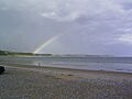
Oxwich Bay, Gower, South Wales
-
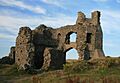
Pennard Castle, on the Gower Peninsula, South Wales
-
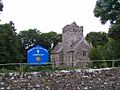
St Cadoc's Church
-
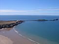
Worm's Head at Rhossili
