
Patagonian Desert facts for kids
Quick facts for kids Patagonia DesertPatagonian Steppe |
|
|---|---|
.jpg)
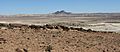
Patagonian Steppe landscape
|
|

Map of the Patagonian Steppe ecoregion
|
|
| Ecology | |
| Realm | Neotropical |
| Biome | temperate grasslands, savannas, and shrublands |
| Borders | Argentine Monte, Magellanic subpolar forests, Southern Andean steppe, and Valdivian temperate forests |
| Geography | |
| Area | 572,883 km2 (221,191 sq mi) |
| Countries | Argentina, Chile, and Falkland Islands (United Kingdom) |
| Coordinates | 41°19′S 69°19′W / 41.32°S 69.32°W |
| Conservation | |
| Conservation status | Critical/endangered |
| Protected | 70,970 km² (12%) |

.jpg)
The Patagonian Desert, also called the Patagonian Steppe, is the biggest desert in Argentina. It is the 8th largest desert in the world. This huge area covers about 673,000 square kilometers (260,000 square miles).
It is mostly in Argentina. The Andes mountains are to its west. The Atlantic Ocean is to its east. This region is part of Patagonia in southern Argentina.
In the north, the desert slowly changes into the Cuyo Region and the Monte. The middle parts of the desert have many shrubs and small plants. Closer to the west, where it rains more, you find more grasses.
The desert land has flat areas called tablelands. It also has hills and mountains cut by river valleys and canyons. In the western parts, there are lakes formed by glaciers. These areas also have bare mountains or cold temperate forests along the valleys.
People have lived in this desert for a very long time. They were hunter-gatherers before European settlers arrived. In the 1800s, people from Argentina, Wales, and other parts of Europe moved here. This changed the area from a wild borderland to a key part of Argentina. Raising cattle, sheep, and horses became the main way people used the land.
The Patagonian Desert has been here for a long time. It formed about 14 to 12 million years ago. This happened as the Andes mountains grew taller in the west.
Contents
Geography and Climate of Patagonia
The Patagonian Desert is the largest desert south of 40° latitude. It is a big, cold desert. Temperatures here rarely go above 12°C (54°F). The average temperature is only about 3°C (37°F).
The region has about seven months of winter and five months of summer. Frost is common, but snow is rare because the air is very dry all year. The Andes mountains are the main reason this area is a desert. They block moisture from the Pacific Ocean from reaching inland. This creates a rain shadow effect. Even though half of the desert is only about 200 miles from the ocean, it stays very dry. The cold Falkland Current in the Atlantic Ocean also makes the area dry.
Different parts of the desert have different climates. The coast north of 45° latitude is warmer. This is because of warm ocean currents from Brazil. The whole northern half of the region is much warmer in summer. Sunny weather is common then.
In summer, daily temperatures can reach 31°C (88°F) near the Rio Colorado. Along the northern coast, it's usually 26°C to 29°C (79-84°F). In the northern plains, it's 24°C to 28°C (75-82°F). Nights are cooler, around 12°C to 15°C (54-59°F) on the coast. In the steppe, nights are 7°C to 10°C (45-50°F).
In the south, summer temperatures are lower. They go from 22°C (72°F) down to 16°C (61°F) along the coast. In the steppes, they drop from 24°C (75°F) to 17°C (63°F). Nights are 8°C to 11°C (46-52°F) on the coast. In the steppe, they are 6°C to 10°C (43-50°F).
During winter, how close you are to the coast and how high up you are matters most. Northern coastal areas have mild winters. Nights are around 2°C (36°F) and days are about 11°C (52°F). Southern Santa Cruz has temperatures from -2°C (28°F) to 5°C (41°F). Tierra del Fuego ranges from -3°C (27°F) to 3°C (37°F), with an average of 0°C (32°F).
Inland, northern areas are 0°C to 10°C (32-50°F) in low places. On plateaus, it's -5°C to 5°C (23-41°F), averaging around 0°C (32°F). In the south, low areas are -3°C to 4°C (27-39°F). Higher areas are usually below 0°C (32°F). The coldest spots can reach -20°C to -25°C (-4 to -13°F) during cold spells. The lowest official temperature recorded was -33.9°C (-29°F) in Chubut province.
Summer frost is common everywhere except the northern coast. Even light snow can fall in the warm season. Winds are always strong, usually blowing from the west.

Before the Andes mountains formed, this region was probably covered by temperate forests. After the Andes grew, ash from nearby volcanoes covered these forests. Water full of minerals soaked into the logs. This turned the trees into fossils, creating one of the world's best petrified forests in the desert's center.
The Patagonian Desert is mostly flat plains of gravel and plateaus. It has sandstone canyons and clay shapes carved by the desert wind. But the whole region has many different features. Rivers, lakes, and water from the Andes' spring melt form every year. These areas are home to many waterfowl and water plants.
There are also many deposits from glaciers, rivers, and volcanoes. These have changed the desert's climate over time. They especially added to the gravel that covers parts of Patagonia. The desert is also very windy. This is because of the rain shadow effect and cool air coming down from the mountains. This wind makes the Patagonian Desert a big source of dust over the South Atlantic Ocean.
To the west, the Patagonian grasslands meet the nothofagus forests of the Magellanic subpolar forests. Volcanic rocks cover over 120,000 square kilometers (46,000 square miles) of the Patagonian Desert. These are mainly in the Somún Cura Massif and the Deseado Massif. Other volcanic areas include the Pali-Aike Volcanic Field near the Strait of Magellan. These volcanic rocks formed from back-arc volcanism. This happened mainly in two periods: one in the Eocene and Miocene epochs, and another from the Late Miocene to the Pleistocene epoch.
Animals and Plants of the Patagonian Desert
Even though the desert is a tough place to live, many animals make their home here. Some animals live on the edges of the desert. Here, there is more food and the environment is less harsh. But all these animals are found within the larger Patagonian region.
- Animals: You might see the burrowing owl, lesser rhea (a type of bird), guanaco (like a small llama), tuco-tuco (a rodent), mara (a large rodent), pygmy armadillo, Patagonian weasel, puma, Patagonian gray fox, desert iguana, and western ribbon snake. Many types of eagles and hawks also live here.
- Plants: The plants here are typical for a desert climate. They include desert shrubs like Acantholippia and Benthamiella. You'll also find tuft grasses like Stipa and Poa. Water plants and larger plants grow on the edges of the desert. They also grow around the temporary lakes that form from the Andes' runoff.
People and History of the Patagonian Desert

In the past, different indigenous peoples lived in this desert. We know this from cave paintings found in the area. The first known inhabitants were the Tehuelche. They were hunter-gatherers. They did not farm, even in the green valleys of the desert.
In the 1700s and 1800s, the northern part of the desert came under Mapuche influence. This was part of a process called Araucanization. The Mapuches started raising horses in the northern Patagonian steppe. Mapuche tribes controlled trade across the desert. They traded with cities in southern Chile, as well as Buenos Aires and the Cuyo Region.
From the mid-1800s, Argentine and European settlements began to appear. Some were temporary. The most important settlement was started by Welsh immigrants in 1860. It was at the mouth of the Chubut River. Perito Moreno explored the desert in the 1870s.
In the 1870s, the Argentine army carried out the Conquest of the Desert campaign. This led to a big change in control of the land. Many indigenous people were displaced. Some moved into Chile or to remote areas in the Andes. The boundary treaty of 1881 between Chile and Argentina officially gave most of the desert to Argentina. Before this, Chile had claimed some of these areas.
In the decades around 1900, sheep farming became very popular in the less dry parts of the Patagonian steppe. This made the region one of the world's top exporters of sheep products.
Today, not many people live in the Patagonian Desert. Those who do mostly raise livestock like sheep and goats. Another way people use the desert is by mining resources. Oil, gas, and coal are found in some parts of the region. This also affects the desert environment.
Protecting the Patagonian Desert
In 2017, a study found that 70,970 square kilometers (about 12%) of this ecoregion is protected. These protected areas help keep the desert's nature safe. Some of these protected areas include:
- Bernardo O'Higgins National Park
- Cerro Castillo National Park
- Bosques Petrificados de Jaramillo National Park
- El Rincón Wilderness Nature Reserve
- Kawésqar National Park
- La Ascensión Wilderness Nature Reserve
- Laguna Blanca National Park
- Laguna del Diamante Nature Reserve
- Laguna San Rafael National Park
- Lanín National Park
- Leicester Falls Nature Reserve
- Los Glaciares National Park
- Monte León National Park
- Pali Aike National Park
- Patagonia National Park (Argentina)
- Patagonia National Park (Chile)
- Patagonia Wilderness Nature Reserve
- Perito Moreno National Park
- Sea Lion Island Nature Reserve
- Valdes Biosphere Reserve
Images for kids
-
Barren Patagonian Desert at the Bosques Petrificados National Park
See also
 In Spanish: Patagonia extraandina para niños
