Pali-Aike volcanic field facts for kids
Quick facts for kids Pali-Aike volcanic field |
|
|---|---|
Pali-Aike
|
|
| Highest point | |
| Geography | |
The Pali-Aike volcanic field is an area with many volcanoes located on the border between Argentina and Chile. It is part of a group of volcanoes in Patagonia that formed behind the main mountain range. These volcanoes appeared because the Chile Ridge (a mountain range under the ocean) crashed into the Peru–Chile Trench (a deep ocean valley). Pali-Aike is further east than the Austral Volcanic Zone, which is the main chain of volcanoes in the Andes Mountains at this latitude.
The volcanic field sits on top of older sedimentary rock from the Magallanes Basin. It started forming about 3.78 million years ago due to big movements in the Earth's crust.
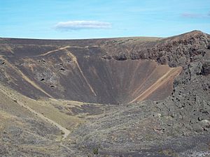
Pali-Aike has older, flat layers of lava called "plateau basalt." It also has many younger volcanoes like cone-shaped hills made of ash and rock (called pyroclastic cones or scoria cones), and wide, flat craters called maars. There are about 467 openings where lava came out, spread across an area of 4,500 square kilometers (1,700 sq mi). These openings often line up along cracks or faults in the ground.
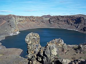
The area is special because its rocks contain many xenoliths, which are pieces of other rocks brought up from deep inside the Earth. Also, the Potrok Aike maar is here, where scientists have found old climate information from its lakebed. The newest eruptions happened recently in Earth's history, during the Holocene period. For example, the Laguna Azul maar formed about 3,400 years ago.
People have lived in this region for thousands of years. Many old archaeological sites, like the Fell Cave, are found here. Today, parts of the volcanic field are protected areas in Chile and Argentina. The city of Rio Gallegos in Argentina is only 23 kilometers (14 mi) away from the volcanic field.
Contents
What's in a Name?
The name Pali-Aike comes from the Tehuelche language. In their language, pale means "hunger" and aike means "location." It was first the name of a farm and later given to the whole volcanic area.
Where is Pali-Aike?
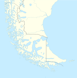
The Pali-Aike volcanic field crosses the border between Argentina and Chile. It's located northwest of the Strait of Magellan. Most of it is in Argentina, in the southern part of Santa Cruz Province. The Chilean part is in the San Gregorio area.
The cities of Rio Gallegos (Argentina) and Punta Arenas (Chile) are near Pali-Aike. It's unusual for volcanoes in Argentina to be so close to cities. The closest volcanic opening is only 23 kilometers (14 mi) from Rio Gallegos, so people in the city can easily see the volcanoes. Important roads and border crossings also pass through the volcanic field. On the Chilean side, there are even hiking trails for visitors.
Land and Volcanoes
How Big is It?
The Pali-Aike volcanic field covers a huge area of 4,500 square kilometers (1,700 sq mi). It stretches for 150 kilometers (93 mi) from northwest to southeast. The area is mostly a flat top made of old lava flows, which can be up to 120 meters (390 ft) thick. This flat area has dips and lakes, and its edges are steep slopes.
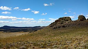
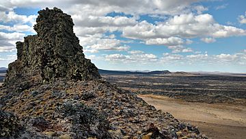
Some old volcanic centers are still visible. There are also "volcanic necks" like Cuadrado, Domeyko, Gay, and Philippi hills. These are the hardened insides of volcanoes that have worn away over time, and they stick out from the flat plains. The volcanic rocks sit on top of older sediments that were smoothed by glaciers.
Types of Volcanoes
There are 467 volcanic openings in the field. Many of these are monogenetic volcanoes, meaning they erupted only once. They sit on the lava plateau and include maars, tuff rings, and scoria cones. These volcanoes rise between 20 and 160 meters (66 and 525 ft) above the surrounding land.
It's common to find craters inside other craters, broken-open craters, and long cracks where lava came out. Lava flows from these volcanoes can be as long as 8 kilometers (5.0 mi). Some of the cone-shaped volcanoes are Aymond, Colorado, Dinero, Fell, and Negro.
The Cerro del Diablo is the youngest volcano here. It's a cone that has erupted both rough, blocky lava (called ʻaʻā) and smooth, ropey lava (called pahoehoe). These lava flows look very fresh and don't have much soil on them. Some lava flows are older and covered with soil, while younger ones are not. The young lava flows also have cool features like lava tunnels (underground tubes), hornitos (small lava mounds), and tumuli (dome-shaped mounds).
Maars and Lakes
Maars are bowl-shaped hollows in the ground, often surrounded by a ring of rock and sediment. They form when hot magma hits water or ice, causing big explosions. In Pali-Aike, there are about 100 maars, ranging from 500 meters (1,600 ft) to 4,000 meters (13,000 ft) wide. They create a unique landscape. The ground in this area has a lot of ice and water, which might explain why there are so many maars.
One famous maar is Laguna Azul, a crater lake inside a ring of ash. This maar formed in three stages with three separate craters and also produced a lava flow. Potrok Aike is much larger, about 5 kilometers (3.1 mi) wide, and its rim is hard to see. Other maars in the area include Laguna Salsa, Laguna del Ruido, Bismarck, Carlota, Los Flamencos, Laguna Salida/Laguna Ana, and Timone Lake.
How Volcanoes Line Up
Many volcanoes in Pali-Aike form lines, usually running from northwest to southeast or from east-northeast to west-southwest. Some older volcanoes line up north-south. These lines happen when cracks in the Earth's crust act like pathways for magma to rise to the surface. These cracks control where the volcanoes appear and even their shapes. These lines match big fault zones like the Magallanes-Fagnano fault.
Water in the Field
The Gallegos River flows north of the volcanic field, and its branch, the Rio Chico, crosses the field. The ground in the volcanic field lets water pass through easily, creating wetlands that attract many birds and springs that provide water.
Besides maars, there are other lakes formed by lava blocking rivers, by glaciers, or by wind blowing away sediment. Some of these lakes dry up in late summer, allowing the wind to pick up sediment from their beds. This creates long dune fields. Scientists have even seen these "windstreaks" growing in Pali-Aike, which is rare on Earth but common on Mars.
Earth's Moving Plates
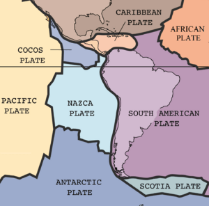
At the southern tip of South America, the Antarctic Plate is slowly sliding under the South America Plate. This process, called subduction, happens at about 2 centimeters (0.79 in) per year. This movement has created volcanoes on the western side of South America, forming the Austral Volcanic Zone.
Patagonia is a place where four of Earth's big tectonic plates meet and interact: the Antarctic Plate, the Nazca Plate, the Scotia Plate, and the South America Plate. About 4 million years ago, the Chile Ridge started to crash into the Peru–Chile Trench. This collision caused a lot of geological activity in the region.
Volcanic History
Volcanic activity at Pali-Aike has been happening from the late Pliocene to the present day (Holocene). Scientists divide the volcanic activity into three main periods: U1 (the oldest, flat lava plateaus), U2 (older individual volcanoes), and U3 (more recent volcanoes with lava flows). There's also an even older volcanic stage from the Miocene period, but those rocks are very worn down.
The youngest volcano is Diablo Negro-La Morada del Diablo, located on the Chile-Argentina border. Its lava covered an area of 100 square kilometers (39 sq mi). Volcanic ash and lava have covered archaeological items in the Pali-Aike Cave. This shows that volcanoes were active between 10,000 and 5,000 years ago, and even within the last 15,000 years. The Global Volcanism Program mentions an eruption around 5,550 BCE. Sediment from Laguna Azul suggests that this maar formed about 3,400 years ago.
In a 2016 study, Pali-Aike was ranked as Argentina's 18th most dangerous volcano out of 38.
Climate, Plants, and Animals
The climate in this region is windy and cold, but winters are mild because of the ocean nearby. It's also quite dry, almost like a semi-desert, with little rainfall. These weather patterns are due to its closeness to Antarctica and cold ocean currents. Scientists have studied sediment from lakes like Laguna Azul and Potrok Aike to learn about past climates.
The area's natural plant life includes grasslands and shrubs. The main grass is Festuca gracillima, but Festuca pallescens is common in wetter areas. You'll also find bushes like Chiliotrichum diffusum and red crowberry in wetter spots, and Nardophyllum bryoides and Nassauvia ulicina in drier areas. Many other small plants and herbs grow here too. The porous volcanic rocks absorb rain, creating underground water sources (aquifers) that feed wetlands.
Many animals live in the Chilean national park part of Pali-Aike. These include armadillos, gray foxes, guanacos, Humboldt's hog-nosed skunks, pumas, and red foxes. Bird species include various geese, black-chested buzzard-eagles, cinereous harriers, crested caracaras, kestrels, peregrine falcons, rheas, and southern lapwings. You can also find water birds like sandpipers, Coscoroba swans, flamingos, two-banded plovers, and different types of ducks.
Records from the past show that the environment in this wider region has changed a lot over the last 50,000 years. Caves have revealed fossils of animals like big cats and ground sloths that lived here long ago. Since Europeans arrived in the late 1800s, new plants and sheep farming have changed the local environment.
Humans and History
Early humans lived in the Pali-Aike region about 10,000 years ago. They used many caves, such as Fell Cave, Pali-Aike cave, Condor 1, Cueva del Puma, Las Buitreras, and Orejas de Burro. They also lived in open-air sites like Laguna Thomas Gould. Humans have been in Fell Cave for at least 8,000 years, making their presence in Pali-Aike some of the oldest in Patagonia. Scientists started studying the archaeology here in the 1930s.
Ancient human activity was mostly in the southern, wetter part of the volcanic field. The lakes and volcanic landscape provided a reliable water supply and shelter, drawing people to the area. They left behind archaeological sites, petroglyphs (rock carvings), and stone tools. Some ancient burials have also been found. The volcanic field was a source of volcanic rocks like obsidian for making tools, but these rocks were not always the best quality. Weathered volcanic rocks from Pali-Aike were also used as red pigments for art.
Today, sheep are farmed in the volcanic field. On the Chilean side, the Pali-Aike volcanic field is part of the Pali-Aike National Park. Some volcanic centers are being looked at as possible "geosites," which are important geological places. Laguna Azul is already a provincial geosite and a popular place for tourism. The Pali-Aike National Park was created in 1970 in Chile, and the Laguna Azul Provincial Reserve was set up in Argentina in 2005.
See also
 In Spanish: Campo volcánico Pali Aike para niños
- Carrán-Los Venados, another volcanic field in Chile with very large maars
 | Calvin Brent |
 | Walter T. Bailey |
 | Martha Cassell Thompson |
 | Alberta Jeannette Cassell |


