Pelican Lagoon facts for kids
Quick facts for kids Pelican Lagoon |
|
|---|---|

Pelican Lagoon
|
|
| Location | Kangaroo Island, South Australia |
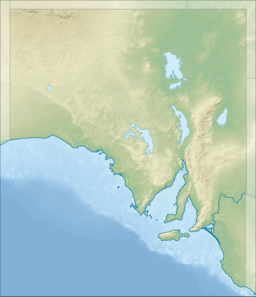
| Coordinates | 35°49′10″S 137°47′24″E / 35.81944°S 137.79000°E |
| Type | seawater lagoon |
| Basin countries | Australia |
| Max. length | 4.5 km (2.8 mi). |
| Max. width | 6 km (3.7 mi) |
| Surface area | 1,520 ha (3,800 acres) |
| Max. depth | 10 m (33 ft) |
| Salinity | sea water |
| Islands | Goanna Islet, Pig Islet, Rabbit Islet, Shag Rock, Samphire Islet, Wallaby Islet and several unnamed islands |
| Settlements | Pelican Lagoon Muston |
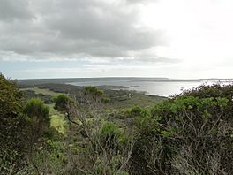
Pelican Lagoon is a beautiful saltwater lagoon located on the north coast of Kangaroo Island in South Australia. It is about 18.7 kilometers southeast of Kingscote. The lagoon was named by explorer Matthew Flinders on April 4, 1802. He saw many pelicans there, which is how it got its name! This special place has been recognized for a long time as an important area for fish and other marine life. Because of this, fishing has been limited here to help protect its natural environment.
Since 1971, Pelican Lagoon has been part of a marine protected area. This means it is a special zone where marine life is protected. All fishing and collecting of sea creatures are not allowed. Since 2012, the Pelican Lagoon Sanctuary Zone has been part of the Encounter Marine Park. It is managed by National Parks South Australia. The lagoon is likely the oldest marine protected area in South Australia, having been protected since 1914.
Contents
Discovering Pelican Lagoon: Location and Features
Pelican Lagoon is a saltwater lagoon found about 2.9 kilometers south of American River. It is also about 18.7 kilometers southeast of Kingscote. The lagoon is surrounded by land. The Dudley Peninsula is to the east, and the main part of Kangaroo Island is to the west. An isthmus (a narrow strip of land) connects these two landmasses to the south. An unnamed peninsula to the north separates the lagoon from Eastern Cove.
How Pelican Lagoon Connects to the Sea
The lagoon connects to Eastern Cove in Nepean Bay through a narrow passage called American River. Hog Bay Road, which is the main road from Penneshaw to Kingscote, runs along the east and south sides of the lagoon.
Branches and Water Flow
Pelican Lagoon has two main parts, or branches. One is on the east side, and the other is on the west side. Matthew Flinders described the west branch as the "southern branch" in 1802. Water flows in and out of the lagoon with the tides. This happens through a narrow channel that is about 3 to 5 meters deep. This channel passes through the west branch to reach the east branch. The tidal flow can be quite strong, moving as fast as 3 knots.
Water Depths in the Lagoon
The west branch of the lagoon is generally shallow. Its average water depth is about 0.9 meters, especially at low tide. The eastern branch has some deeper areas. Most of its north side ranges in depth from 3 to 9.9 meters. The south side of the eastern branch also has several deeper spots, usually between 1 and 2.9 meters deep.
Small Islands (Islets) in the Lagoon
Many small islands, called islets, are found within Pelican Lagoon. Six of these islets have names. From east to west, they are: Rabbit Islet, Goanna Islet, Pig Islet, Wallaby Islet, Shag Rock, and Samphire Islet.
Plants and Animals of Pelican Lagoon
Pelican Lagoon is home to a wide variety of plants and animals. Its different environments, from land to water, support many species.
Plants: Life on Land and in Water
Land Plants (Terrestrial Flora)
The islands inside the lagoon have special plant areas called heathlands. These are mostly covered by plants like Coastal Daisybush and Thyme Riceflower. The coastline around the lagoon also has many types of plants. These include heathlands with Acacia leiophylla and Orthrosanthus multiflorus. You can also find herb lands with Senecio odoratus, coastal mallee scrub with Eucalyptus diversifolia, and samphire flats. There are also areas of grazed grasslands.
Water Plants (Intertidal and Subtidal Flora)
In the lagoon, samphire plants grow on the muddy areas that are uncovered when the tide is low. The deeper underwater areas, called subtidal areas, are mostly covered by seagrass. The main types of seagrass here are Heterozostera tasmanica and Posidonia australis. Various kinds of algae (seaweed) are also present in the lagoon.
Animals: Wildlife and Marine Life
Land Animals (Terrestrial Fauna)
Many waterbirds use the lagoon, and nine different species actually breed there. These include the chestnut teal, pied oystercatcher, sooty oystercatcher, and caspian tern. Seventeen waterbird species found here are protected by international agreements. Sixteen are listed under the Japan-Australia Migratory Bird Agreement (JAMBA), and seventeen under the China-Australia Migratory Bird Agreement (CAMBA). Black tiger snakes have also been seen on the islands within the lagoon.
Water Animals (Intertidal and Subtidal Fauna)
Pelican Lagoon is an important breeding spot for the little penguin. The lagoon also supports many marine animals that are valuable for fishing. These include sand crabs, king scallops, queen scallops, razorfish, southern calamari, flathead, King George whiting, leatherjacket, red mullet, snook, Southern Sea garfish, tommy ruff, trevally, and Western Australian salmon. A group of bottle-nosed dolphins also calls the lagoon home.
History of Pelican Lagoon
European Discovery and Early Use
The lagoon was first discovered by European explorer Matthew Flinders on April 4, 1802. He named it "Pelican Lagoon" because of the large number of pelicans he saw there at the time. After South Australia was settled, the lagoon was also sometimes known as American River. Before 1919, people mined guano (bird droppings used as fertilizer) from the islands in the lagoon. They did this with permission from the South Australian Government.
Protecting the Lagoon's Fisheries
As early as May 1905, using nets for fishing was banned in Pelican Lagoon and nearby waters like American River and Eastern Cove. By 1908, the South Australian government recognized Pelican Lagoon as an important "hatchery area" for fish. This was stated by Mr. S. McIntosh, who was the Deputy Chief Inspector of Fisheries at the time. By early 1925, the lagoon was completely closed to all types of fishing. The islands within the lagoon first became protected areas on March 16, 1967. They were declared a fauna (animal) conservation reserve under the Crown Lands Act 1929-1966.
Nearby Towns and Settlements
Pelican Lagoon is bordered by two towns. To the west, you will find the town of Muston. To the south and east, the town of Pelican Lagoon is located. Both of these areas have land set aside for homes and living.
Protected Status of Pelican Lagoon
Pelican Lagoon is part of several important protected areas, showing how special it is:
- The American River Aquatic Reserve used to cover the entire lagoon, but it was officially closed in 2016.
- Pelican Lagoon Conservation Park includes five of the islands in the lagoon. It also covers much of the land on the peninsula to the north of the lagoon.
- Since 2012, the Pelican Lagoon Sanctuary Zone has been part of the Encounter Marine Park. This park is managed by National Parks South Australia. Pelican Lagoon is likely the oldest marine protected area in South Australia, having been protected since 1914.
The lagoon is also listed as a nationally important wetland in South Australia. It is part of what is called the "American River Wetland System."
 | Isaac Myers |
 | D. Hamilton Jackson |
 | A. Philip Randolph |


