
Pen Ty-Nant facts for kids
Quick facts for kids Pen Ty-Nant |
|
|---|---|
 |
|
| Highest point | |
| Elevation | 332 m (1,089 ft) |
| Prominence | 35 m (115 ft) |
| Parent peak | Arenig Fawr |
| Listing | TuMP |
| Naming | |
| English translation | Summit above the house by the stream |
| Language of name | Welsh |
| Geography | |
| Location | Gwynedd, Wales |
| Parent range | Arenigs |
| OS grid | SH902368 |
| Topo map | OS Landranger 124 / "Explorer" OL18 |
Pen Ty-Nant (which means "Summit above the house by the stream" in English) is a hill located in the beautiful Snowdonia National Park in Gwynedd, North Wales. It's a great spot for exploring the Welsh countryside!
Contents
Where is Pen Ty-Nant Located?
Pen Ty-Nant is part of the Arenig mountain range. It's quite close to some interesting places. This hill is only about 1 mile (1.6 km) from a tiny village called Rhyd-uchaf. It's also just 2.3 miles (3.7 km) from the town of Bala.
How Does it Connect to Other Peaks?
Pen Ty-Nant's "parent peak" is Arenig Fawr, which is a bigger mountain about 5 miles (8 km) to the west. Pen Ty-Nant is actually part of a small ridge. This ridge starts near Bala and stretches all the way to Moel y Garnedd. This area is known as the Gwastadros moorland.
What Can You See from the Top?
When the weather is clear, the views from Pen Ty-Nant are amazing! You can see many other mountains and landmarks.
Mountains and Lakes to the North
Looking northwest, you might spot Pen yr Ole Wen. This mountain is part of the Carneddau range and appears above Llyn Celyn, a lake about 22 miles (35 km) away. To the north and northeast, you can see Carnedd y Filiast, Moel y Gydros, and Moel Emoel.
Views to the East and South
To the east, you can see the Clwydian Range summits like Moel y Gamelin and Moel Morfydd. Closer by, you'll see Mynydd Mynyllod with its wind turbines near Glan-yr-afon. The impressive peaks of the Berwyn range, including Cadair Berwyn and Cadair Bronwen, are visible above Bala Lake to the east and southeast. Looking southwest, you can spot Aran Benllyn, Cadair Idris, and Rhobell Fawr.
Distant Landmarks
Some of the furthest things you can see include Tarren y Gesail, which is about 23 miles (37 km) away near Abergynolwyn. You might also see Cefn y Cist, a part of Esclusham Mountain, also about 23 miles (37 km) to the east.
How to Reach the Summit
Reaching the top of Pen Ty-Nant is a relatively easy adventure!
Short Walk from Rhyd-uchaf
A quick way to get to the summit starts in the village of Rhyd-uchaf. This round trip usually takes about 45 minutes, making it a perfect short hike.
Path from Bala
If you're starting from Bala, you can follow a bridle path that leads directly to the hill. The very top of the summit is on open farmland and doesn't have any special markers.
Images for kids
-
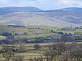
Pen Ty-Nant, a hill in Snowdonia National Park.
See also
 In Spanish: Eryri para niños
