
Port of Spain facts for kids
Quick facts for kids
Port of Spain
|
||
|---|---|---|
| City of Port of Spain | ||

Port of Spain in 2012
|
||
|
||
| Motto(s):
"We Gather Strength As We Go Along"
|
||

Port of Spain
Location in Trinidad and Tobago

Port of Spain
Location in Caribbean

Port of Spain
Location in North America
|
||
| Country | ||
| Jurisdiction | City of Port of Spain | |
| Settled | 1560 | |
| Borough | 19 August 1853 | |
| City | 26 June 1914 | |
| Government | ||
| • Body | City of Port of Spain | |
| City Corporation seats | 12 electoral districts | |
| House seats | 2/41 | |
| Area | ||
| • Capital city | 12 km2 (5 sq mi) | |
| Elevation | 66 m (217 ft) | |
| Population
(2011)
|
||
| • Capital city | 37,074 | |
| • Rank | 3rd | |
| • Density | 3,639/km2 (9,420/sq mi) | |
| • Urban | 81,142 | |
| Languages | ||
| • Official | English | |
| Time zone | UTC-4 (AST) | |
| Postal Code |
10xxxx, 12xxxx, 16xxxx – 19xxxx, 21xxxx, 23xxxx, 24xxxx, 26xxxx, 29xxxx
|
|
| Area code(s) | 868 | |
| ISO 3166 code | TT-POS | |
| Telephone Exchanges | 619, 623, 624, 625, 627, 641, 661, 821, 622, 628, 822 | |
| HDI The HDI for Trinidad and Tobago is 0.814, which gives the country a rank of 19th out of 177 countries with data (2007/2008) – high | ||

Port of Spain, officially the City of Port of Spain, is the capital city of Trinidad and Tobago. It is the third largest city in the country. The city is home to about 37,074 people (2011 census). However, many more people, around 250,000, visit the city every day for work or other activities.
Port of Spain is located on the northwest coast of the island of Trinidad. It sits by the Gulf of Paria. The city is part of a larger connected area that stretches from Chaguaramas in the west to Arima in the east. This bigger area has an estimated population of 600,000 people.
The city is a major center for shopping and government services. It has been the capital of Trinidad since 1757. Port of Spain is also an important place for financial services in the Caribbean. It hosts two of the biggest banks in the region. The main airport for the island, Piarco International Airport, connects the capital to many places around the world.
Port of Spain was also the capital of the West Indies Federation for a short time. This federation tried to unite several Caribbean islands. The city has the largest container port on the island. It is a key shipping hub in the Caribbean. Goods like farm products and manufactured items are sent from here. Bauxite from Guyana is also shipped through facilities near the city. The pre-Lenten Carnival is the city's biggest yearly cultural event. It attracts many tourists.
Today, Port of Spain is a leading city in the Caribbean. Trinidad and Tobago hosted the Fifth Summit of the Americas in 2009. Important guests like US President Barack Obama attended this event. The city also has the largest and most successful stock exchange in the Caribbean. This is the Trinidad and Tobago Stock Exchange (TTSE). Tall buildings like the Nicholas Tower make up the city's skyline. Some of the tallest skyscrapers in the Caribbean are found here.
Contents
- Discovering Port of Spain's Past
- Port of Spain's Location and Landscape
- Homes in Port of Spain
- Port of Spain's Economy
- Learning in Port of Spain
- People and Buildings of Port of Spain
- Fun and Culture in Port of Spain
- City Infrastructure
- Countries with Offices in Port of Spain
- Partner Cities
- Images for kids
- See also
Discovering Port of Spain's Past

Port of Spain was founded by the Spanish. They called it Puerto España. The first settlement was near an Amerindian fishing village. This village was called Cumucurapo. It meant "place of the silk cotton trees". In 1560, Spanish soldiers set up a base near the Laventille Hills. These hills now form the city's eastern border.
The area closest to the sea in downtown Port of Spain was once muddy land with mangroves. The first Spanish buildings were simple huts made of mud. They were built among large silk cotton trees. A small fort was also built with mud walls. It had a few cannons and soldiers. In 1595, Walter Raleigh captured this fort.
By 1757, the old capital, San José de Oruña, was in bad shape. So, the Governor moved his office to Port of Spain. This made Port of Spain the new capital of Trinidad. The last Spanish Governor, Don José Maria Chacón, worked hard to improve the city. He made the island's governing council move to Port of Spain. In 1783, a new law encouraged French Catholics to settle on the island. This caused the town to grow quickly.
From a small group of buildings, eleven streets were planned. They went west towards the St. Ann's River. This created the grid pattern you still see in downtown Port of Spain today. Along the seashore was the Plaza de la Marina, a parade ground. By 1786, the town had about 3,000 people.

The St. Ann's River often flooded the town. To fix this, Governor Chacón changed its path in 1787. The river was moved to the east of the city. Now, Port of Spain could spread north and west. It began to take over nearby sugar cane farms.
In 1797, British forces invaded Trinidad. They landed west of Port of Spain. Governor Chacón surrendered to avoid fighting and destruction. Port of Spain remained the capital. The new British government renamed most streets after British figures. However, Chacón Street kept its name to honor the former governor.

In 1803, Port of Spain started growing southwards. Mudflats along the coast were filled in with earth from the Laventille Hills. This area is now called Sea Lots. More land was reclaimed in the 1840s, 1870s, and 1906. In 1935, the Deep Water Harbour Scheme created more land. This new land was used for government buildings.
Port of Spain continued to grow in the 19th and early 20th centuries. Its population reached about 100,000 in the 1960s. Since then, the population within the city limits has decreased. The downtown area became more focused on business. Suburbs in the valleys around the city grew instead. Today, Port of Spain is the western part of a large metropolitan area. This area stretches from Carenage to Arima.
From 1958 to 1962, Port of Spain was the temporary capital of the West Indies Federation. There were plans to build a new capital nearby. Federation Park, a neighborhood in western Port of Spain, reminds us of that time.
In July 1990, an extremist group took the prime minister and lawmakers hostage. Rioting and looting happened in Port of Spain. This caused a lot of damage to the city's business area. However, businesses eventually recovered. In 2005, there were some small bombings in the city. They stopped in October 2005.
Port of Spain's Location and Landscape

Port of Spain covers about 10.4 square kilometers (4 sq. mi). It is in the northwest of Trinidad. The city is located between the Gulf of Paria, the Northern Range mountains, and the Caroni Swamp.
The Northern Range is a chain of tall, green hills. These mountains are home to many different plants and animals. Over 465 types of birds and 100 types of mammals live here. Port of Spain sits at the western end of these mountains. The city climbs into the hills, where people have built homes.
The Caroni Swamp is a protected area of 3,278 hectares. It has stopped the city from growing south. This has pushed urban growth eastward. The swamp is the island's second largest wetland. It has over 160 bird species, including the national bird, the scarlet ibis. It is a popular place for tourists to visit.
Some parts of the city are built on land reclaimed from the Gulf of Paria. This is a calm bay between Trinidad and Venezuela. Other parts of the city climb into the hills. The Port of Port of Spain is great for ships. It has a natural harbor where bad weather is rare.
Port of Spain has a cooler climate than other cities like Chaguanas. This is because of the surrounding Northern Range mountains.
City Views and Neighborhoods

Downtown Port of Spain
This is the main business area of the city. It is the oldest part of Port of Spain. Downtown is the cultural and financial heart of Trinidad and Tobago. It is also important for the wider Caribbean region. Here you will find the Trinidad and Tobago Stock Exchange and the Central Bank of Trinidad and Tobago. Many of the city's tallest buildings are located here.
Woodbrook
This is a large area that used to be a sugar farm. It was sold to the city in 1911. Woodbrook became a residential neighborhood. It is known for its unique "gingerbread" houses. It also has many parks and green spaces.
Saint James
North of Woodbrook, Saint James is the last area added to the city. Since the late 1800s, it has been a center for the Indian population. Many streets here are named after places in South Asia. Saint James is known for its nightlife. People call it "The City that never sleeps."
Newtown
This district in north Port of Spain has many churches and schools. Newtown has grown into a busy business area. Many foreign embassies are located here.
Saint Clair
Saint Clair is an upscale business and residential area. It is located between the Queen's Park Savannah and the Maraval River. This district has some of the city's grandest mansions. It is also home to the Magnificent Seven Houses. Federation Park and Ellerslie Park, two very fancy neighborhoods, are also in Saint Clair.
Belmont
Belmont is a district at the foot of the Laventille Hills. It was the city's first suburb. In the 1840s and 1850s, some parts were settled by Africans. They were rescued by the Royal Navy from illegal slave ships. Belmont became known as "the Black St. Clair" because black professionals built large homes there. Today, Belmont is a middle-class neighborhood. Many famous Carnival designers were born here.
Nearby Towns and Suburbs
- Laventille is a working-class neighborhood east of the St. Ann's River. It spreads over the hills around the city. Laventille is known as the birthplace of the steelpan. It is also considered a spiritual capital for calypso. Steelpan and Carnival are very important to many Trinidadians living in the capital. South of Laventille are Beetham Estate and Sea Lots.
North and northwest of Port of Spain are the suburbs of Cascade, St. Ann's, and Maraval. St. Ann's is where the Prime Minister's official home is located. Cascade is a suburban area with many trees. Maraval has the exclusive Trinidad Country Club.
Further west, you find Westmoorings. This suburb is known for its expensive high-rise apartments by the sea. The Falls at West-Mall, a fancy shopping center, is also here. The Chaguaramas peninsula, once a US Army Base, is now a popular spot for international boaters.
To the east, along the East–West Corridor, are the towns of San Juan, Tunapuna, and Arima. Large shopping centers like Valsayn Shopping Centre and Trincity Mall have grown here. Two major universities are also in the eastern part of this corridor. These are the University of the West Indies and the University of Trinidad and Tobago.
Port of Spain's Climate
The city has a tropical monsoon climate. This means it has warm to hot temperatures all year. There is little change in seasons because it is close to the equator. Temperatures usually range from 19 to 34 °C (66.2 to 93.2 °F). They rarely go above 35 °C (95 °F) or below 17 °C (62.6 °F). The wet season is from May to December. The dry season is from January to April.
| Climate data for Port of Spain (Piarco International Airport) (1991-2020 normals, extremes 1961-2020) | |||||||||||||
|---|---|---|---|---|---|---|---|---|---|---|---|---|---|
| Month | Jan | Feb | Mar | Apr | May | Jun | Jul | Aug | Sep | Oct | Nov | Dec | Year |
| Record high °C (°F) | 33.6 (92.5) |
36.3 (97.3) |
35.7 (96.3) |
36.3 (97.3) |
35.9 (96.6) |
34.7 (94.5) |
35.1 (95.2) |
35.8 (96.4) |
36.5 (97.7) |
36.2 (97.2) |
34.9 (94.8) |
34.2 (93.6) |
36.5 (97.7) |
| Mean daily maximum °C (°F) | 31.0 (87.8) |
31.3 (88.3) |
32.1 (89.8) |
32.8 (91.0) |
32.7 (90.9) |
31.7 (89.1) |
32.0 (89.6) |
32.6 (90.7) |
33.0 (91.4) |
32.6 (90.7) |
31.9 (89.4) |
31.2 (88.2) |
32.1 (89.8) |
| Daily mean °C (°F) | 26.6 (79.9) |
26.7 (80.1) |
27.3 (81.1) |
28.2 (82.8) |
28.5 (83.3) |
28.0 (82.4) |
28.0 (82.4) |
28.2 (82.8) |
28.5 (83.3) |
28.3 (82.9) |
27.7 (81.9) |
27.0 (80.6) |
27.8 (82.0) |
| Mean daily minimum °C (°F) | 22.1 (71.8) |
22.2 (72.0) |
22.5 (72.5) |
23.6 (74.5) |
24.3 (75.7) |
24.3 (75.7) |
24.0 (75.2) |
23.9 (75.0) |
24.0 (75.2) |
23.9 (75.0) |
23.6 (74.5) |
22.8 (73.0) |
23.4 (74.1) |
| Record low °C (°F) | 15.6 (60.1) |
16.1 (61.0) |
16.7 (62.1) |
17.2 (63.0) |
18.9 (66.0) |
19.7 (67.5) |
18.3 (64.9) |
18.9 (66.0) |
19.4 (66.9) |
19.4 (66.9) |
17.9 (64.2) |
16.7 (62.1) |
15.6 (60.1) |
| Average precipitation mm (inches) | 79.6 (3.13) |
48.6 (1.91) |
40.6 (1.60) |
51.6 (2.03) |
109.4 (4.31) |
243.4 (9.58) |
228.8 (9.01) |
255.3 (10.05) |
179.1 (7.05) |
192.9 (7.59) |
222.9 (8.78) |
149.0 (5.87) |
1,801.2 (70.91) |
| Average precipitation days (≥ 1 mm) | 11.2 | 8.3 | 6.1 | 6.1 | 10.9 | 19.0 | 19.4 | 18.4 | 14.5 | 15.3 | 16.9 | 15.0 | 161.1 |
| Average relative humidity (%) | 80.1 | 77.3 | 75.3 | 75.6 | 78.0 | 82.5 | 82.5 | 82.7 | 82.4 | 83.3 | 84.8 | 82.7 | 80.6 |
| Average dew point °C (°F) | 21.8 (71.2) |
21.3 (70.3) |
21.4 (70.5) |
22.3 (72.1) |
23.2 (73.8) |
23.7 (74.7) |
23.7 (74.7) |
23.9 (75.0) |
24.0 (75.2) |
23.9 (75.0) |
23.7 (74.7) |
22.8 (73.0) |
23.0 (73.4) |
| Mean monthly sunshine hours | 254.6 | 241.9 | 261.5 | 256.6 | 251.8 | 199.9 | 227.1 | 224.0 | 212.0 | 212.7 | 197.4 | 225.9 | 2,765.4 |
| Source: NOAA | |||||||||||||
City Layout and Growth

Port of Spain's official population is small. This is because the city limits are narrow. They include the main business area and some suburbs. However, the larger connected area, the East–West Corridor, has about 600,000 people. This corridor is a built-up area in north Trinidad. It stretches from Port of Spain east to Arima. It includes towns like San Juan and Tunapuna. These were once separate communities. Now they are part of one continuous urban area.
Parks and Green Spaces
Queen's Park Savannah: A Giant Roundabout Park


Port of Spain's largest open space is the Queen's Park Savannah. It is also known as the world's largest traffic roundabout. People often just call it "the Savannah." It covers about 260 acres (105 hectares) of flat land. The distance around its edge is about 2.2 miles (3.5 km). This land was once a sugar farm. The city bought it in 1817.
At first, it was used for grazing cattle. By the mid-1800s, it became a park. Horse racing used to happen often at the Savannah race track. It also has fields for cricket, football, and rugby. The Savannah was never really landscaped, except for a small area called the Hollows. This used to be a reservoir.

Just north of the Savannah are the Royal Botanic Gardens. You can also find the Emperor Valley Zoo here. The President's House and the Prime Minister's official home are also nearby. Queen's Hall is the city's main place for performing arts. Lady Chancellor Road, which goes up the hills overlooking the Savannah, is a very exclusive residential area.
On the south side of the Savannah is the Grand Stand. It was used for watching horse races. Now, it hosts cultural events, especially Carnival. During Carnival, a temporary stage is built here. This area becomes the "Big Yard," the main Carnival location. The Parade of Bands is broadcast live from here. The Calypso Monarch and Carnival King and Queen Competitions also take place here. The beautiful Port of Spain National Academy for the Performing Arts is also on the south side.
The western edge of the Savannah has the Magnificent Seven. These are a group of old buildings built in unique styles. They include the Queen's Royal College and the residences of religious leaders. Whitehall was once the Prime Minister's office. Mille Fleurs is being restored as a museum. Roomor and Stollmeyer's Castle are also part of this group.

Homes in Port of Spain

Homes in Port of Spain vary greatly. You can find fancy waterfront apartments. There are also simpler homes without indoor plumbing. The city's population has decreased in the last 40 years. This is because more businesses are moving into residential areas.
To help with housing, the East Port of Spain Development Company was created in 2005. Its goal is to improve the eastern parts of the city. Many old warehouses and poor-quality homes have been removed. Several new government housing projects are being built or planned.
Port of Spain's Economy

Port of Spain is a major shopping and business center for Trinidad and Tobago. Most government offices are located here. Many important government services can only be found in the downtown ministries. In recent years, local banks have helped the city become a financial hub for the Caribbean. Two of the largest banks in the Caribbean, Republic Bank, Trinidad and Tobago Limited and Royal Bank of Trinidad and Tobago, have their main offices here.
Trinidad's economy relies on natural gas and oil. There are no heavy industries in Port of Spain itself. However, many oil and gas companies have their headquarters in the city. They want to be close to government services and enjoy the city's high quality of life. Some of these companies include BPTT, BGTT, and BHP Billiton.

Trinidad and Tobago is one of the wealthiest nations in the Caribbean. Some of this wealth is seen in Port of Spain. Money from selling natural gas has helped build projects like the Port of Spain International Waterfront Centre.
The Port of Port of Spain is the country's main port for container shipping. Cruise ships also dock here. The port handles cargo and operates the ferry service between Trinidad and Tobago.
Tourism is growing in the city's economy. However, it is not as important as in other Caribbean cities. Port of Spain also has a large "central market." Here, food from the surrounding areas is bought and sold.
Learning in Port of Spain


In 1999/2000, there were 40 government-supported schools in Port of Spain. About 17,957 students were in primary schools. Another 15,641 students were in secondary schools. Education is free and required up to secondary school.
Students from Port of Spain do not pay tuition for local and regional public colleges. This is true unless they are doing graduate studies. There are several important colleges in and around Port of Spain. The University of the West Indies has a campus in St. Augustine. It had over 15,571 students in 2007/2008. The University of Trinidad and Tobago also has several campuses nearby.
People and Buildings of Port of Spain
Port of Spain has a diverse population. In 2011, there were 18,008 males and 19,066 females. The city has 5,694 businesses and 12,333 households. The average household size is 2.9 people. The city's population has decreased by about 2.3% per year between 2000 and 2011.
The city's diverse population shows two centuries of immigration. This is reflected in its buildings. You can see French colonial "gingerbread" houses. There are also buildings with wrought-iron railings like those in New Orleans. Modern high-rise towers stand next to these. Gothic-style cathedrals, mosques, and Hindu temples show the mix of cultures.
Port of Spain is home to people from many backgrounds. These include African, Indian, French, English, Spanish, Portuguese, Venezuelan, Chinese, Jewish, and Arab immigrants. Most of them arrived after 1783. Famous citizens include Derek Walcott (Nobel Prize winner) and cricketer Brian Lara.
| Historical populations | ||
|---|---|---|
| Year | Pop. | ±% |
| 1901 | 54,100 | — |
| 1946 | 92,793 | +71.5% |
| 1960 | 93,954 | +1.3% |
| 1970 | 73,950 | −21.3% |
| 1988 | 59,200 | −19.9% |
| 2000 | 49,031 | −17.2% |
| 2011 | 37,074 | −24.4% |
| Port of Spain annexed St. James in 1938. | ||
| Administrative Corporation | Population |
|---|---|
| Port of Spain | 37,074 |
| Diego Martin | 102,957 |
| San Juan/Laventille | 157,258 |
| Tunapuna/Piarco | 215,119 |
| Arima | 33,606 |
| Total | 546,014 |
| Source: 2011 Census |
People of Port of Spain: A Diverse Mix
| Racial composition | 2011 |
|---|---|
| Black (Afro-Trinidadian/Tobagonian) | 51.5% |
| Multiracial | 19.4% |
| Dougla (Indian and Black) | 10.3% |
| Indians (Indo-Trinidadian) | 9.5% |
| White Trinidadian | 1.6% |
| East Asian (Chinese) | 1% |
| Native American (Amerindian) | 0.2% |
| Arab (Syrian/Lebanese) | 0.4% |
| Other | 0.6% |
| Not stated | 5% |
Fun and Culture in Port of Spain
Trinidad has many cultures. This creates many celebrations beyond what you might expect for a small island. There is always something to see and do in Port of Spain. This is true even after the yearly Carnival. While the main shopping area has remained popular, entertainment has spread to malls and other towns.
St. James and "uptown" Port of Spain have seen many new nightclubs and restaurants. Workers from government offices and big companies fill these places in the evenings.
Nightlife and Food
Port of Spain has many nightclubs and entertainment spots. Famous international and regional performers have visited the city. These include Beyoncé, Chris Brown, Rihanna, and Nicki Minaj.
You can find many types of restaurants in Port of Spain. These include Italian, Mexican, Lebanese, Thai, and Indian food. Many are on Ariapita Avenue, a popular entertainment street. This street also has a Jazz Lounge and a Wine Tasting restaurant. MovieTowne's Fiesta Plaza has new restaurants and live entertainment. You can try many of the city's restaurants at the Taste T&T Food Festival. It happens every May.
Arts and Performances
Port of Spain is a cultural center. Dance and theater shows happen regularly at:
- The Little Carib: This is one of the oldest theaters in the country. It was started in 1947 by dance legend Beryl McBurnie.
- Queen's Hall: Built in 1959, this hall hosts plays and community events. It seats 782 people.
- The Central Bank Auditorium: Built in 1986, it helps promote performing arts. It seats 400 people.
- The Port of Spain National Academy for the Performing Arts (NAPA): This is the city's newest arts center. It has a 1500-seat performance hall. It also has a hotel for visiting performers. NAPA hosted Queen Elizabeth II in 2009.
Port of Spain is the center of one of the world's largest Carnivals. Tens of thousands of people take part in this street party.
One of Port of Spain's most famous artists is Peter Minshall. He creates "mas" or masquerade costumes for Carnival. He also helped design ceremonies for the Olympics and the Football World Cup.
Museums to Explore
The National Museum and Art Gallery is the country's most important museum. It shows national festivals like Carnival. It also displays life during World War II. You can see artifacts from the first settlers, the Amerindians. The museum also features works by local and international artists. It was founded in 1892.
The National Museum has two smaller branch museums:
- Fort San Andres: This fort was built in 1787. It was once located offshore and connected by a bridge.
- The Trinidad and Tobago Police Service Museum: This museum is at the Old Police Headquarters.
City Infrastructure
Getting Around Port of Spain

Port of Spain has a very busy road system. Traffic delays are common during morning and evening rush hours. The city's main roads have CCTV cameras, signs, and other safety features.
- Entering from the East: Traffic comes from the east on the six-lane Churchill–Roosevelt Highway. It becomes the Beetham Highway as it enters the city. Then it meets Broadway and becomes Wrightson Road. Another way is to take the two-lane Lady Young Road. The Eastern Main Road also runs into the city. The Priority Bus Route is for buses only. It enters the city at City Gate.
- Entering from the West: Traffic from the west uses the Western Main Road and the four-lane Audrey Jeffers Highway. Smaller mountain roads also offer entry points.
There are also important inner-city roads. Ariapita Avenue is one of them. It is the center of the city's nightlife. The Queen's Park Savannah is said to be the world's largest roundabout. Tragarete Road runs into St. James. It also leads to the Queen's Park Oval.
Public Transportation Options
City Gate is a major hub for public buses and private mini-buses (called maxi-taxis). It is located on South Quay. The PTSC has improved its services. They now offer free WiFi on coach buses. They also have a new waiting area and new buses.
A ferry service connects Port of Spain with Scarborough, Tobago. A water taxi service links it with San Fernando. The ferry terminal is on South Quay. The water taxi terminal is part of the Port of Spain International Waterfront Centre.
Air Travel
Port of Spain is served by the Piarco International Airport. It is located in Piarco, about 21 km (13 mi) east of the city. You can reach it via the Churchill Roosevelt Highway.
Future Transport Plans
To reduce traffic, several projects are planned. These include upgrading the Churchill–Roosevelt highway. They also plan to extend water ferry services along the west coast.
City Services
Electricity is produced by Powergen. It is distributed by the Trinidad and Tobago Electricity Commission (T&TEC). Port of Spain gets its power from plants in other areas.
Telecommunications are managed by the Telecommunications Authority of Trinidad and Tobago (TATT). They have allowed more companies to offer phone and internet services. Digicel and Flow now offer wireless and broadband services. High-speed internet is available throughout the city. Free Wi-Fi hotspots are at major hotels, coffee shops, malls, and the airport.
Water and sewage services are handled by the Water and Sewerage Authority (WaSA). Much of the city's water comes from the Caroni Arena Dam. The new Beetham Waste Water Treatment Plant cleans domestic waste. Most solid waste goes to the Beetham Landfill.
Mobile and Internet Providers
- Digicel
- bmobile
- FLOW
- Amplia
- DirecTV
- Green Dot
Countries with Offices in Port of Spain
Partner Cities
Port of Spain has "sister city" relationships with other cities:
 Atlanta, United States
 Georgetown, Guyana
 Lagos, Nigeria
 Morne-à-l'Eau, Guadeloupe, France
- Richmond, United States
 St. Catharines, Canada
Images for kids
-
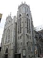
Historic Gothic Rosary Church at the corner of Henry and Park Streets 2008
-
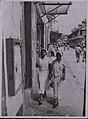
Indo-Trinidadian women shopping in Port of Spain in 1945


See also
 In Spanish: Puerto España para niños
