
Quakertown, Pennsylvania facts for kids
Quick facts for kids
Quakertown, Pennsylvania
|
||
|---|---|---|
|
Borough
|
||

Broad Street in Quakertown in September 2012
|
||
|
||
| Etymology: the Quakers | ||
| Motto(s):
"The Heart of Upper Bucks County!"
|
||

Location of Quakertown in Bucks County, Pennsylvania.
|
||

Quakertown, Pennsylvania
Location in Pennsylvania

Quakertown, Pennsylvania
Location in the United States
|
||
| Country | United States | |
| State | Pennsylvania | |
| County | Bucks | |
| Government | ||
| • Type | Council-manager | |
| Area | ||
| • Total | 2.04 sq mi (5.27 km2) | |
| • Land | 2.04 sq mi (5.27 km2) | |
| • Water | 0.00 sq mi (0.00 km2) | |
| Elevation | 505 ft (154 m) | |
| Population
(2020)
|
||
| • Total | 9,359 | |
| • Density | 4,599.02/sq mi (1,775.87/km2) | |
| Time zone | UTC−5 (EST) | |
| • Summer (DST) | UTC−4 (EDT) | |
| ZIP Code |
18951
|
|
| Area codes | 215, 267, 445 | |
| Website | quakertown.org | |

Quakertown is a small town, also called a borough, in Bucks County, Pennsylvania. In 2020, about 9,359 people lived there.
This borough is about 15 miles (24 km) south of Allentown and Bethlehem. It's also about 40 miles (64 km) north of Philadelphia. This means Quakertown is a "border town" between the Delaware Valley and Lehigh Valley areas. The area around Quakertown is called Richland Township.
Contents
History of Quakertown

Quakertown was first settled by a religious group called the Quakers.
The 1700s: Early Days and the Liberty Bell
On September 18, 1777, during the American Revolutionary War, something very important happened here. A group of wagons was moving the Liberty Bell from Philadelphia to Allentown. They stopped in Quakertown for the night. The Liberty Bell was kept safe behind the home of Evan Foulke. The people traveling with it stayed at the Red Lion Inn. Later, in 1799, a protest called the John Fries' Rebellion also began at the Red Lion Inn.
The 1800s: Growth and Freedom
In 1803, Quakertown got its first post office. This is when the community officially got its name. Before the Civil War, Quakertown was a key spot on the Underground Railroad. This was a secret network that helped enslaved people find freedom. A local leader named Richard Moore helped over 600 people escape.
The Civil War and the growth of the country helped Quakertown change. It grew from a small village into a busy center for making things. In the 1800s, factories in Quakertown made cigars, cigar boxes, silk, harnesses, and stoves. In 1854, Quakertown chose its first leader, called a Burgess. The arrival of the North Pennsylvania Railroad made it easier to get to Quakertown. This caused the population to grow a lot. By 1880, nearly 1,800 people lived there.
The 1900s: Historic Places and Trolleys
Quakertown has four important historical places. They are listed on the National Register of Historic Places. These include Liberty Hall, the Quakertown Historic District, the Quakertown Passenger and Freight Station, and the Enoch Roberts House.
From 1901 to 1951, an electric trolley line ran through Quakertown. It connected Allentown and Coopersburg to the north with Philadelphia to the south. During World War II, when gas was hard to get, many people used the trolley. However, after the war, fewer people rode it, and the service stopped in 1951. The old trolley station building still stands in Quakertown.
The 2000s: Modern Quakertown
Today, Quakertown has many modern shopping areas along Pennsylvania Route 309. You can find restaurants, businesses, and stores there. Quakertown's population has continued to grow. In 1900, there were 3,014 people. By 2010, the population was 8,979.
Geography and Climate
Quakertown covers about 2.0 square miles (5.2 square kilometers) of land. A stream called Licking Run flows through the town. It eventually drains into the Tohickon Creek. The Tohickon Creek then flows into the Delaware River.
Climate in Quakertown
Quakertown has a climate with warm summers. Most summer days are a bit humid. Sometimes, it can get very hot and humid. The highest temperature recorded since 1981 was 101.9°F (38.8°C) in July 2011. The wettest month is usually July, which is when most thunderstorms happen.
In winter, it gets cold. The average coldest temperature each year is about -1.9°F (-18.8°C). The coldest temperature recorded since 1981 was -13.7°F (-25.4°C) in January 1984. Quakertown usually gets between 30 and 36 inches (76 to 91 cm) of snow each winter. Sometimes, big snowstorms or ice storms happen.
| Climate data for Quakertown, Elevation 502 ft (153 m), 1991-2020 normals, extremes 1981-2018 | |||||||||||||
|---|---|---|---|---|---|---|---|---|---|---|---|---|---|
| Month | Jan | Feb | Mar | Apr | May | Jun | Jul | Aug | Sep | Oct | Nov | Dec | Year |
| Record high °F (°C) | 69.8 (21.0) |
77.6 (25.3) |
86.3 (30.2) |
92.5 (33.6) |
93.9 (34.4) |
94.9 (34.9) |
101.9 (38.8) |
98.6 (37.0) |
96.2 (35.7) |
88.9 (31.6) |
79.4 (26.3) |
73.9 (23.3) |
101.9 (38.8) |
| Mean daily maximum °F (°C) | 37.8 (3.2) |
41.0 (5.0) |
49.6 (9.8) |
61.7 (16.5) |
71.8 (22.1) |
80.3 (26.8) |
84.2 (29.0) |
82.6 (28.1) |
75.9 (24.4) |
64.3 (17.9) |
53.1 (11.7) |
41.6 (5.3) |
62.1 (16.7) |
| Daily mean °F (°C) | 29.1 (−1.6) |
31.5 (−0.3) |
39.3 (4.1) |
50.2 (10.1) |
60.0 (15.6) |
69.0 (20.6) |
73.4 (23.0) |
71.8 (22.1) |
64.4 (18.0) |
53.0 (11.7) |
43.1 (6.2) |
33.2 (0.7) |
51.6 (10.9) |
| Mean daily minimum °F (°C) | 20.4 (−6.4) |
22.1 (−5.5) |
29.0 (−1.7) |
38.7 (3.7) |
48.2 (9.0) |
57.7 (14.3) |
62.6 (17.0) |
61.0 (16.1) |
53.0 (11.7) |
41.6 (5.3) |
33.1 (0.6) |
24.8 (−4.0) |
41.1 (5.1) |
| Record low °F (°C) | −13.7 (−25.4) |
−6.5 (−21.4) |
1.8 (−16.8) |
16.0 (−8.9) |
31.0 (−0.6) |
39.4 (4.1) |
45.9 (7.7) |
40.8 (4.9) |
33.4 (0.8) |
22.6 (−5.2) |
10.0 (−12.2) |
−3.0 (−19.4) |
−13.7 (−25.4) |
| Average precipitation inches (mm) | 3.50 (89) |
2.83 (72) |
3.71 (94) |
4.08 (104) |
4.33 (110) |
4.35 (110) |
4.80 (122) |
3.87 (98) |
4.58 (116) |
4.35 (110) |
3.77 (96) |
4.07 (103) |
48.24 (1,225) |
| Average relative humidity (%) | 68.7 | 66.4 | 61.3 | 59.9 | 63.8 | 70.0 | 69.9 | 72.8 | 73.6 | 71.4 | 71.2 | 71.5 | 68.4 |
| Average dew point °F (°C) | 19.9 (−6.7) |
21.6 (−5.8) |
27.1 (−2.7) |
36.8 (2.7) |
47.7 (8.7) |
58.8 (14.9) |
63.0 (17.2) |
62.6 (17.0) |
55.8 (13.2) |
44.0 (6.7) |
34.4 (1.3) |
25.0 (−3.9) |
41.5 (5.3) |
| Source: PRISM | |||||||||||||
Local Environment
The natural plants in Quakertown are mostly Oak trees. The area is known for its Eastern Hardwood Forests. Spring flowers usually start blooming around April 12. The leaves change color in the fall, usually peaking around October 28.
Population and People
| Historical population | |||
|---|---|---|---|
| Census | Pop. | %± | |
| 1850 | 242 | — | |
| 1860 | 528 | 118.2% | |
| 1870 | 863 | 63.4% | |
| 1880 | 1,769 | 105.0% | |
| 1890 | 2,169 | 22.6% | |
| 1900 | 3,014 | 39.0% | |
| 1910 | 3,801 | 26.1% | |
| 1920 | 4,391 | 15.5% | |
| 1930 | 4,883 | 11.2% | |
| 1940 | 5,150 | 5.5% | |
| 1950 | 5,673 | 10.2% | |
| 1960 | 6,305 | 11.1% | |
| 1970 | 7,276 | 15.4% | |
| 1980 | 8,867 | 21.9% | |
| 1990 | 8,982 | 1.3% | |
| 2000 | 8,931 | −0.6% | |
| 2010 | 8,979 | 0.5% | |
| 2020 | 9,359 | 4.2% | |
| Sources: | |||
In 2020, Quakertown had 9,359 people. Most residents (88.3%) were White. Other groups included African American (5.3%), Asian (2.0%), and people from other races (2.7%). About 2.9% of people were from two or more races. About 5.4% of the population was Hispanic or Latino.
In 2000, there were 3,421 households in Quakertown. About 32.9% of these households had children under 18 living with them. The average age of people in Quakertown was 36 years old.
Getting Around Quakertown
Roads for Driving
_just_north_of_Mill_Road_in_Quakertown,_Bucks_County,_Pennsylvania.jpg)
Quakertown has many public roads. Some are kept up by the state, and others by the borough itself. Four main state highways pass through or near Quakertown:
- PA 309 goes through the western part of town. It connects Quakertown to Allentown in the north and Philadelphia in the south.
- PA 313 starts in Quakertown and heads southeast towards Doylestown.
- PA 663 goes west from Quakertown. It connects to I-476 (the Pennsylvania Turnpike) and continues southwest to Pottstown.
- PA 212 heads northeast from Quakertown. It leads to Riegelsville.
Bus Services
You can travel to and from Quakertown by bus.
- Trans-Bridge Lines offers bus service from Quakertown to Doylestown and to New York City.
- Fullington Trailways has buses from a special parking lot on PA 663. These buses go to Philadelphia, Hazleton, Williamsport, and other places in Northeastern Pennsylvania.
- Martz Trailways also uses the PA 663 parking lot. Their buses go to Scranton, Wilkes-Barre, Allentown, and Philadelphia. These routes connect to Amtrak trains in Philadelphia.
Train Services
Quakertown used to have passenger train service until 1981. Now, only freight trains use the tracks. The East Penn Railroad provides freight service for local businesses.
Air Travel
The Quakertown Airport is a public airport for small planes. It's located just outside Quakertown.
Town Services
Quakertown provides many services to its residents.
- The Quakertown Electric Department provides electricity. The town has managed its own electricity since the 1890s.
- The Quakertown Water Department provides water from ten wells.
- The Quakertown Sewer Department handles wastewater and has its own treatment plant.
- UGI Utilities provides natural gas.
- The Quakertown Sanitation Department collects trash and recycling.
Police and Fire Departments

The Quakertown Borough Police Department keeps the town safe 24 hours a day. It has a Chief, detectives, sergeants, and patrol officers.
Fire protection is provided by the Quakertown Fire Department. This is a volunteer fire department with two stations: Quakertown Fire Company #1 and West End Fire Company.
Schools in Quakertown
The Quakertown Community School District serves public school students in the borough.
- Quakertown Elementary School and Neidig Elementary School are for students in kindergarten through 5th grade.
- The Sixth Grade Center is for 6th graders.
- Strayer Middle School serves grades 7-8.
- Quakertown Community High School is for grades 9-12.
For students who attend private religious schools, the Archdiocese of Philadelphia operates St. Isidore school in Quakertown. The United Friends School is also located in the borough.
Famous People from Quakertown
Many interesting people have connections to Quakertown:
- Megan Angelo, a journalist and author
- Karen Bliss, a former American cyclist
- Tom Bossert, a lawyer and former Homeland Security Advisor to U.S. President Donald Trump
- Diane Bracalente, a field hockey player in the 1988 Summer Olympics
- Sabrina Carpenter, a singer and actress
- Katlyn Chookagian, a UFC fighter
- Reuben Swinburne Clymer, a writer and leader of a spiritual group
- Jill Davis (tennis), a former professional tennis player
- Charles Fechter, an Anglo-French actor
- Oliver W. Frey, a former member of the U.S. House of Representatives
- Ray Hartranft, a professional baseball player for the Philadelphia Phillies
- John Robert Kline, an American mathematician and educator
- Tim Lewis, a former professional football player for the Green Bay Packers
- Will Lewis (American football), an American football executive and former player for teams like the Seattle Seahawks
- Bill Mensch, a pioneer in microcomputers
- Richard Moore, an abolitionist who helped people escape slavery
- George Papashvily, a writer and sculptor
- Frances Quinlan, a singer-songwriter and artist known for the band Hop Along
- Rebecca Quinn (cyclist), a professional racing cyclist
- Louis Riddick, a former professional football player and sports analyst
- Robb Riddick, a former professional football player for the Buffalo Bills
- Jeff Rodenberger, a former professional football player for the New Orleans Saints
- Priscilla Kepner Sage, a textile and fiber artist
- Ken Schroy, a former professional football player for the New York Jets
- Jan Shepard, a film and television actress
- Clyde Smoll, a professional baseball player for the Philadelphia Phillies
- Meredith Stern, an artist, musician, and disc jockey
- Hampton S. Thomas, a Medal of Honor recipient from the American Civil War
- Neil Vipond, a Canadian-American actor
Images for kids
-
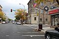
Broad Street in Quakertown in September 2012
-
Seal of Quakertown
-
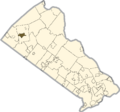
Location of Quakertown in Bucks County, Pennsylvania.
-
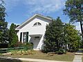
Richland Friends Meeting House, the Quaker meeting house in Quakertown in August 2016
-
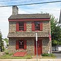
Liberty Hall in Quakertown in August 2016
-
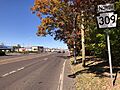
PA 309 northbound in Quakertown
-
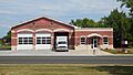
West End Fire Company in Quakertown in August 2016

See also
 In Spanish: Quakertown para niños
