
Racine County, Wisconsin facts for kids
Quick facts for kids
Racine County
|
||
|---|---|---|

|
||
|
||

Location within the U.S. state of Wisconsin
|
||
 Wisconsin's location within the U.S. |
||
| Country | ||
| State | ||
| Founded | December 7, 1836 | |
| Seat | Racine | |
| Largest city | Racine | |
| Area | ||
| • Total | 792 sq mi (2,050 km2) | |
| • Land | 333 sq mi (860 km2) | |
| • Water | 460 sq mi (1,200 km2) 58%% | |
| Population
(2020)
|
||
| • Total | 197,727 | |
| • Estimate
(2023)
|
196,613 |
|
| • Density | 594.4/sq mi (229.5/km2) | |
| Time zone | UTC−6 (Central) | |
| • Summer (DST) | UTC−5 (CDT) | |
| Congressional district | 1st | |

Racine County is a county located in southeastern Wisconsin. It's a place where many people live and work. In 2020, about 197,727 people called Racine County home. This makes it the fifth-largest county in Wisconsin by population.
The main city and county seat of Racine County is Racine. The county was first created in 1836. At that time, it was part of the Wisconsin Territory, before Wisconsin became a state. Racine County is also part of a larger area called the Milwaukee-Racine-Waukesha combined statistical area. This means it's connected to the bigger Milwaukee city area. The county covers about 792 square miles. A large part of this area, 58%, is water.
Contents
History of Racine County
Before European settlers arrived, the Potawatomi people lived in the area that is now Racine County. They were the original inhabitants of this land.
Founding the County
The government of the Wisconsin Territory officially created Racine County in 1836. It was separated from Milwaukee County to form its own area. When it was first made, Racine County was much larger. It stretched all the way to Wisconsin's southern border. It even included the land that is now Kenosha County, Wisconsin.
Changes Over Time
Later, in 1850, Kenosha County was separated from Racine County. It became its own independent county. This change helped shape Racine County into the size and shape it is today.
Geography of Racine County
Racine County is in a unique spot in Wisconsin. It shares borders with several other counties. It also has a large body of water nearby.
Neighboring Areas
Here are the counties that border Racine County:
- Milwaukee County to the north
- Kenosha County to the south
- Walworth County to the west
- Waukesha County to the northwest
Across Lake Michigan, Racine County is also near:
- Ottawa County, Michigan to the northeast
- Allegan County, Michigan to the southeast
The Root River
The Root River flows through the county. This river is very important because it's where Racine County gets its name!
Population and People
Understanding the population helps us learn about the people who live in Racine County.
Population Changes Over Time
The number of people living in Racine County has grown a lot since 1840.
- In 1840, there were 3,475 people.
- By 1900, the population had grown to 45,644.
- In 1950, it reached 109,585 people.
- The latest count in 2020 showed 197,727 people living here.
Who Lives in Racine County?
According to the 2020 census, Racine County is home to a diverse group of people.
- About 72% of the population is White.
- Around 11.8% are Black or African American.
- About 1.2% are Asian.
- About 0.5% are Native American.
- About 5.4% are from other races.
- About 9% are from two or more races.
- Also, about 14.1% of the population identifies as Hispanic or Latino. People of Hispanic or Latino background can be of any race.
Getting Around Racine County
Racine County has many ways for people and goods to travel. This includes major roads, train lines, buses, and airports.
Main Roads
Many important highways pass through Racine County, connecting it to other parts of Wisconsin and beyond. These include:


 I-41 / I-94 / US 41
 US 45
US 45 WIS 11
 WIS 20
 WIS 31
 WIS 32
 WIS 36
 WIS 38
 WIS 75
 WIS 83
 WIS 142
 WIS 164
 WIS 311
Train Services
Several train companies operate in Racine County, moving both people and freight:
- Amtrak (for passengers)
- Canadian National
- Canadian Pacific
- Union Pacific
- The Sturtevant station is a key train stop in the county.
Bus Services
- Ryde Racine provides bus transportation within the county.
Airports
There are several airports in and around Racine County that help people travel by air:
- John H. Batten Airport (KRAC)
- Burlington Municipal Airport (KBUU)
- Cindy Guntly Memorial Airport (62C)
- Fox River Airport (96C)
- Sylvania Airport (C89)
Communities in Racine County
Racine County is made up of several different types of communities, including cities, villages, towns, and smaller places.
Cities
- Burlington (partly in Walworth County)
- Racine (the county seat)
Villages
- Caledonia
- Elmwood Park
- Mount Pleasant
- North Bay
- Raymond
- Rochester
- Sturtevant
- Union Grove
- Waterford
- Wind Point
- Yorkville
Towns
Census-Designated Places
These are areas that are like towns but are not officially incorporated as cities or villages.
- Bohners Lake (in the Town of Burlington)
- Browns Lake (in the Town of Burlington)
- Eagle Lake (in the Town of Dover)
- Tichigan (in the Town of Waterford)
- Wind Lake (in the Town of Norway)
Unincorporated Communities
These are smaller communities that are not officially part of a city or village.
- Beaumont
- Buena Park
- Caldwell
- Cedar Park
- Eagle Lake Manor
- Eagle Lake Terrace
- Franksville
- Honey Creek (partial)
- Honey Lake (partial)
- Husher
- Ives Grove
- Kansasville
- Kneeland
- North Cape
- Raymond
- Rosewood
- Sylvania
- Union Church
- Yorkville
Former Communities
Some places that used to be communities in Racine County are now considered "ghost towns" or old neighborhoods.
Images for kids
-
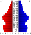
This chart shows the age groups of people in Racine County from the 2000 census.


See also
 In Spanish: Condado de Racine para niños
