Rajouri district facts for kids
Quick facts for kids
Rajouri district
|
|
|---|---|
|
District of Jammu and Kashmir administered by India.
|
|

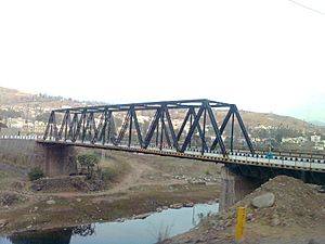
Bridge in Rajouri
|
|

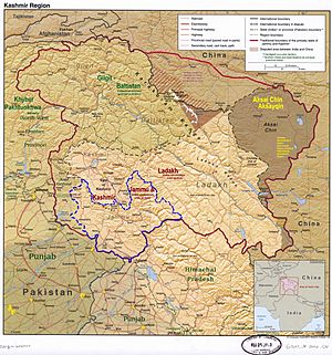
Rajouri district is in the Jammu division (shown with neon blue boundary) of Indian-administered Jammu and Kashmir (shaded in tan in the disputed Kashmir region
|
|
| Administering country | India |
| Union Territory | Jammu and Kashmir |
| Division | Jammu |
| Headquarters | Rajouri |
| Tehsils | 1.Rajouri 2.Manjakote 3.Darhal 4.Qila Darhal 5.Thana Mandi 6.Kotranka 7.Khawas 8.Teryath 9.Kalakote 10.Beri Pattan 11.Sunderbani 12.Nowshera 13.Siot |
| Area | |
| • Total | 2,630 km2 (1,020 sq mi) |
| Population
(2011)
|
|
| • Total | 642,415 |
| • Density | 244.3/km2 (632.6/sq mi) |
| • Urban | 8.1% |
| Demographics | |
| • Literacy | 68.17% |
| • Sex ratio | 860 |
| Time zone | UTC+05:30 (IST) |
| Vehicle registration | JK-11 |
| Website | http://rajouri.nic.in/ https://rajouri.in/ |
Rajouri, also known as Rajpur, is a district located in the Jammu division of Jammu and Kashmir, a territory in India. It shares borders with the Line of Control to the west, Poonch to the north, Reasi district to the east, and Jammu district to the south. Rajouri is well-known for its "Kalari," a special dairy product made from milk.
Rajouri was once an ancient kingdom. In 1947, when the princely state joined India, Rajouri was part of a larger district that included Reasi. Later, these two areas were separated. Rajouri was then joined with the Poonch district. However, in 1968, Rajouri became a separate district once again.
The Rajouri district is made up of 13 tehsils, which are like local administrative areas. The land is mostly fertile and has many mountains. The main crops grown here are maize, wheat, and rice. The Tawi River, which starts in the Pir Panjal mountains, is the main source of water for farming.
Contents
Exploring Rajouri's Geography
The Rajouri district shares its western border with Azad Kashmir, which is controlled by Pakistan. To the north, it borders the Indian-controlled part of Poonch district. The Reasi district is to its east, and the Jammu district is to its south.
The northern parts of Rajouri district are located in the Pir Panjal mountain range. This includes areas like Thanamandi and Darhal. The Rajouri Tawi River (also known as Naushera Tawi) and its smaller rivers flow through these mountain valleys. This makes the valleys suitable for people to live in. The Ansi river also provides water to the Budhal area.
In the southern part of the district, there is a wide valley. It lies between the Tain Dhar and Kali Dhar mountain ranges. These ranges are part of the outer Himalayas. This valley is called either Naushera valley or Lam-Khuiratta valley. A smaller range, called Koti Dhar, runs between Tain Dhar and Kali Dhar. It divides the valley into two sections.
The Line of Control, which separates the Indian-administered and Pakistani-administered parts of Kashmir, follows parts of the Kali Dhar and Koti Dhar ranges. The old Mughal Road used to go through Rajouri to the Kashmir Valley. However, this road is now blocked by the Line of Control. Another road between Sunderbani and Kotli in the Lam-Khuiratta valley is also no longer in use.
Rajouri's Past: A Look at History
Ancient Times
Some historians believe that a group of ancient people, called Aryans, traveled across the Himalayas. They settled in the Rajouri and Poonch areas. Rajouri, along with BhimberGali and Naushera, was part of a hill state called Abhisar. This state was part of the Punjab Kingdom.
Old records show that around 400 BCE, there was a system of small states in northwest India. Abhisar, with its capital in Rajouri, was one of them. Rajouri was very important during the time of Alexander the Great's invasion. Later, during the Mauryan period, Rajouri became a major center for trade.
Early Modern History
During the time of the Mughal Empire, the Muslim Jarral Rajput rulers of Rajouri made an agreement with the Mughals. Because of this, they were given the titles 'Raja' and 'Mirza'. Their descendants still use these titles today.
A famous scholar named Albaruni visited Rajouri in 1036 CE. He came with Sultan Masud, the son of Sultan Mahmud. In his book "India," Albaruni called Rajouri "Raja Vari." Another writer, Srivar, also used the name Raja Vari in his book "Raj Tirangini." Many believe that Raja Vari is a different way of saying Rajapuri.
Mirza Zafarulla Khan, who wrote "Tarikh Rajgan-E-Rajour," said that the place was first known as Raj-Avar. Then it changed to Rajour and later to Rajouri. However, older people in the villages still call it Rajour. Over time, the name changed many times, from Raja's Raj Avar to Rajapuri, then to Raj Vari, and finally to Rajouri.
According to the book "Rajtirangini" by Kalhan, Rajouri became a kingdom around 1003 CE. Its first ruler was Raja Prithvi Paul. From 1033 to 1194 CE, Raja Prithvi Paul protected the Pir Panchal Pass when Sultan Mehmud tried to invade in 1021 CE. Raja Sangram Paul also bravely defended his kingdom when Raja Harash of Kashmir attacked in 1089 AD. Sangram Paul fought so well that Raja Harash had to leave without capturing Rajouri.
The Jaral Muslim Rajas rebuilt the city of Rajouri during their rule. They built many forts, inns (sarais), mosques, and special buildings called baradaris. The Rajouri kingdom included areas like Rajouri itself, Thanna, Bagla Azim Garh, Behrote, Chingus, Darhal, Nagrota, and Phalyana.
Modern History
In 1813, Gulab Singh of Jammu took control of Rajouri for the Sikh Empire. He defeated Raja Agar Ullah Khan. After this, Rajouri became part of the Sikh Empire. However, some parts of it were given to Rahim Ullah Khan, and other parts went to Gulab Singh.
After a war between the British and the Sikhs, and a treaty in 1846, all the lands between the Ravi and Indus rivers were given to Gulab Singh. He became the independent Maharaja of Jammu and Kashmir. This is how Rajouri became part of the princely state. Gulab Singh changed Rajouri's name to Rampur. He appointed Mian Hathu as the Governor of Rajouri, who stayed until 1856. Mian Hathu built a beautiful temple near Rajouri city and also the Rajouri Fort.
Later, Rajouri became a tehsil (a smaller administrative area) and was part of the Bhimber district. In 1904, it was moved from Bhimber and became part of the Reasi district.
Partition of India
After India became independent in 1947, and Jammu and Kashmir joined India, a war broke out between India and Pakistan. On November 7, 1947, Pakistani raiders and local fighters captured Rajouri. The town was later recaptured by the Indian Army on April 12, 1948. The Indian Army found that much of the town had been destroyed. After the army arrived, about 1,500 people who had hidden in the hills returned. The ceasefire line, which ended the war, was drawn to the west of Rajouri district.
Rajouri's Journey in India
After the war, the Rajouri and Reasi areas were separated. Rajouri was joined with the Indian-controlled Poonch district to form the Poonch-Rajouri district. Reasi was joined with the Udhampur district.
On January 1, 1968, the two areas were brought back together. The new district was named Rajouri district. In 2006, Reasi tehsil was again made into its own separate district, the Reasi district. So, the current Rajouri district is mostly the same as the Rajouri tehsil from 1947.
Recent Events
On February 27, 2019, the Pakistan Air Force (PAF) flew across the Line of Control (LoC). They carried out airstrikes in Rajouri District. Pakistani officials said they targeted Indian military supply depots. Indian military officials confirmed the airstrikes. They said the bombs landed in empty areas and caused no damage.
On January 1, 2023, some attackers entered three houses in Dangri village, Rajouri district. They opened fire on civilians, killing four people and injuring many others. The next day, on January 2, 2023, an explosive device (IED) went off near the same attack site. This blast killed a child and injured five more people.
How Rajouri is Organized
The Rajouri district includes subdistricts like Sunderbani, Nowshera, Kotranka, and Kalakote. Its tehsils are Rajouri, Darhal, Sunderbani, Budhal, Kotranka, Khawas, Manjakote, Nowshera, Thanamandi, and Kalakot.
The district is divided into 19 blocks. These blocks include Rajouri, Darhal, Kotranka, Sunderbani, Doongi, Nowshera, Kalakote, Manjakote, Thanamandi, Budhal, Dhangri, Khawas, Lamberi, Moghla, Panjgrain, Plangar, Qila Darhal, Rajnagar, Seri, and Siot. Each block is made up of several panchayats, which are local village councils.
There are plans to build new power stations in Rajouri. These stations will help provide more electricity to Rajouri, Poonch, and Mendhar. The new stations will use modern electrical technology.
Rajouri is home to Baba Ghulam Shah Badshah University, also known as BGSBU. This university offers many different courses. There is also a Government Medical College and other colleges in the district.
Rajouri's Political Landscape
The Rajouri district has four areas that elect representatives to the assembly: Nowshera, Darhal, Rajouri, and Kalakote. It also has 14 areas for the district development council. These include Budhal New, Budhal Old-A, Budhal Old-B, Darhal, Dhangri, Doongi, Kalakote, Manjakote, Moughla, Nowshera, Rajouri, Seri, Sunderbani, and Thanamandi. Rajouri District is part of the Jammu-Rajouri-Poonch area for national elections.
People of Rajouri: Demographics
| Historical population | ||
|---|---|---|
| Year | Pop. | ±% |
| 1901 | 136,281 | — |
| 1911 | 146,823 | +7.7% |
| 1921 | 157,430 | +7.2% |
| 1931 | 166,126 | +5.5% |
| 1941 | 184,049 | +10.8% |
| 1951 | 177,789 | −3.4% |
| 1961 | 171,529 | −3.5% |
| 1971 | 217,373 | +26.7% |
| 1981 | 302,500 | +39.2% |
| 1991 | 384,435 | +27.1% |
| 2001 | 483,284 | +25.7% |
| 2011 | 642,415 | +32.9% |
| † 1951 and 1991 populations are estimated Source: Census of India |
||
| Religion in Rajouri district (2011) | ||||
|---|---|---|---|---|
| Religion | Percent | |||
| Islam | 62.71% | |||
| Hinduism | 34.54% | |||
| Sikhism | 2.41% | |||
| Other or not stated | 0.34% | |||
According to the 2011 census, Rajouri district has a population of 642,415 people. This makes it the 518th most populated district out of 640 in India. The district has about 235 people per square kilometer. Its population grew by 28.14% between 2001 and 2011.
Rajouri has a sex ratio of 863 females for every 1000 males. The literacy rate (the percentage of people who can read and write) is 68.54%. About 7.5% of the population belongs to Scheduled Castes, and 36.2% belong to Scheduled Tribes.
While Urdu and English are used for teaching, the main local languages are Pahari-Pothwari and Gujari. Pahari is mostly spoken by the Malik community, who are a large group in Darhal Malkan. Gujari is mainly spoken by the Gujjar and Bakarwal communities, who make up a big part of Rajouri's Muslim population. Small groups of people also speak Kashmiri and Dogri.
| Sex Ratio in Rajouri District in 2011 Census. (no. females per 1,000 males) |
||||
|---|---|---|---|---|
| Religion (and population) | Sex Ratio | |||
| Muslim (pop 402,879) | 923 | |||
| Hindu (pop 221,880) | 776 | |||
| Sikh (pop 15,513) | 646 | |||
| Other (pop 2,143) | 476 | |||
| Total (pop 642,415) | 860 | |||
See also
 In Spanish: Distrito de Rajouri para niños
- Ghari Momin
- Azmatabad
- Kalakote
- 2023 Rajouri Terror attacks
 | William L. Dawson |
 | W. E. B. Du Bois |
 | Harry Belafonte |

