
Red Rock Canyon State Park (California) facts for kids
Quick facts for kids Red Rock Canyon State Park |
|
|---|---|
 |
|

Red Rock Canyon State Park
Location in California

Red Rock Canyon State Park
Location in the United States
|
|
| Location | Kern County, California, United States |
| Nearest city | Cantil, California |
| Area | 27,000 acres (110 km2) |
| Elevation | 2,600 feet (790 m) |
| Established | 1968 |
| Governing body | California Department of Parks and Recreation |
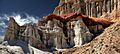
Red Rock Canyon State Park is a super cool place in California. It's known for its amazing desert cliffs, tall rock formations called buttes, and other spectacular rocks. This park covers about 27,000 acres (109 km²) in the Mojave Desert.
You can find the park along California State Route 14 in Kern County, California. It's about 80 miles (129 km) east of Bakersfield, California and 25 miles (40 km) north of Mojave, California. This is where the southern tip of the Sierra Nevada mountains meets the El Paso Mountains Wilderness.
Each canyon in the park has its own unique, bright colors. After a rainy winter, the park bursts with beautiful flowers. You might spot roadrunners, hawks, lizards, mice, and squirrels here. Red Rock Canyon offers awesome views of the desert, has two special nature preserves, and is a great spot for camping, sightseeing, horseback riding, and hiking. It's also a perfect place to enjoy some quiet time.
Contents
Finding Your Way: Park Location
The park is right on California State Route 14. This road connects U.S. Route 395 in California with cities in Southern California. In Southern California, this road is known as the Antelope Valley Freeway.
Red Rock Canyon State Park is about 25 miles (40 km) northeast of Mojave, California on State Route 14. The highway actually goes right through the middle of the park. There are no gas stations or stores inside the park. However, you can find places to camp, picnic, and use restrooms just off California Route 14. The small town of Cantil, California is also nearby.
A Look Back: Park History
Long ago, the Kawaiisu people lived in this area. You can still find ancient rock carvings called petroglyphs and pictographs in the El Paso Mountains. These were made by the ancestors of the Coso people, who were some of the first people to live here. They carved many designs into the rocks of the El Paso and nearby mountains. They also traded a lot with other tribes, even as far as the Chumash people on the Pacific coast.
In the early 1870s, the colorful rocks in the park were important landmarks. They helped guide the famous twenty-mule team freight wagons that hauled borax. These wagons would stop in the canyon for water. Today, the park protects important sites where fossils are found. It also preserves the remains of mining operations from the 1890s.
Then and Now: Changes Over Time


These two photos show how Red Rock Canyon changed over 66 years. The first picture is from 1933. Back then, Red Rock Canyon was on U.S. Route 6. This was a busy road that went from Bishop, California to Los Angeles, along the east side of the Sierra Nevada mountains. The beautiful scenery along this road eventually led to the creation of Red Rock Canyon State Park in 1968. In the 1933 photo, you can see a dirt road crossing the middle of the view.
In the 1999 photo, you can see many more plants. There are 17 different types of plants in the front of the picture. Interestingly, no Yucca plants, Joshua trees, or other plants from the 1933 photo lasted for 66 years. Most Yucca plants don't live much longer than 40 years. The increase in plants in 1999 is partly because there was less disturbance to the land. Also, there was more rain in the later part of the 20th century. For example, the old road that was in the 1933 photo is now hard to see. The ground in the front of this view is still changing, with small channels and ditches crossing parts of it. Areas like this, which are still forming, grow new plants fairly quickly once they are no longer disturbed.
Lights, Camera, Action: Filming Location
Red Rock Canyon is a favorite spot for Hollywood. It has many unique and dramatic areas, and it's close to Los Angeles. Since the 1930s, many movies, TV shows, commercials, and music videos have been filmed here.
Some of the many western movies filmed here include The Big Country and The Outlaw. Other famous movies filmed at the park are Beneath the Planet of the Apes (1970), Buck Rogers (serial), Capricorn One, The Mummy, Zorro Rides Again, Jurassic Park, I'll Be Home for Christmas, Missile to the Moon, The Car, Westworld, and Savages.
TV series like Airwolf, Galactica 1980, Lost in Space, and The Twilight Zone also used the park as a backdrop. 40 Guns to Apache Pass, the last movie starring Audie Murphy, was filmed here in 1966. The 2005 music video for "Cater 2 U" by Destiny's Child was shot at Red Rock Canyon. Also, the 2006 video for the British rock band Muse's song "Knights of Cydonia" was filmed in the park.
Stargazing: Astronomy at the Park
Red Rock Canyon has some of the darkest skies you can find within a two-hour drive of Los Angeles. The dry weather, often clear skies, and not much light pollution make it a great place to look at the stars at night.
The park is a Bortle class 2-3 site. This means it has an "average dark sky" in its northern parts and a sky typical of a rural area in its southern parts. On a clear night when there is no moon, if you have good eyesight and your eyes are used to the dark, you might even see the Andromeda galaxy and Triangulum galaxy without a telescope! The center of the Milky Way galaxy also looks amazing and detailed from here. Even though the southern sky has some light pollution from nearby towns, the dark skies in the park are still much better than in nearby cities.
Images for kids
-

A prominent rock formation near the park entrance.
-
Detail of the many hoodoos found along the canyon walls.
-
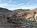
A rocky valley shaped by uplift and erosion.
-
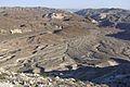
An alluvial plain in the center of the park.


.jpg)

