
Richmond Hill, Leeds facts for kids
Quick facts for kids Richmond Hill |
|
|---|---|
 Shopping Mart and Church Hall, Upper Accommodation Road |
|

Richmond Hill
|
|
| OS grid reference | SE316334 |
| Metropolitan borough | |
| Metropolitan county | |
| Region | |
| Country | England |
| Sovereign state | United Kingdom |
| Post town | LEEDS |
| Postcode district | LS9 |
| Dialling code | 0113 |
| Police | West Yorkshire |
| Fire | West Yorkshire |
| Ambulance | Yorkshire |
| EU Parliament | Yorkshire and the Humber |
| UK Parliament |
|
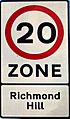
Richmond Hill is a lively area in Leeds, West Yorkshire, England. It's about one mile east of the city centre. This district is located between York Road, East End Park, and Cross Green. It's part of the Burmantofts and Richmond Hill ward in Leeds.
Contents
A Look Back at Richmond Hill
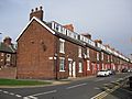
Richmond Hill grew a lot in the late 1700s and 1800s. It became a place where people lived and worked. At first, there were small cottages. But during the industrial revolution (a time when factories and machines changed how things were made), many new homes were built. These were often "back-to-back" terrace houses, built close together for all the new workers.
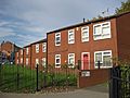
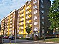
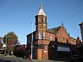
Upper Accommodation Road is a very old part of the area. Some of the oldest buildings are on its west side. A building from the Leeds Industrial Co-operative, built in 1902, stands on a corner with East Park Road. In the 1900s, many homes were updated. The Saxton Gardens estate was later rebuilt by Urban Splash. It now has 410 homes, garden plots, and the city's largest shared garden.
Historic Churches of Richmond Hill
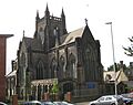
Four churches were built in the Richmond Hill area. On top of the hill is St Saviour Church. It's an Anglican church built in 1845 and is a very important historic building.
Nearby is the old Roman Catholic Mount St Mary's Church. It opened in 1857 but closed in 1989. This church was built for the Irish community who moved to the area in the 1850s. It was once thought to be the biggest parish church in Europe. Mount St Mary's Catholic High School started as a school for this same community.
On York Road, All Saints Church (now closed) was built in 1980. It replaced an older, larger church. Newbourne Methodist Church opened in 1971 on Upper Accommodation Road. It was designed by Charlton and Crowther, architects from Leeds. This church stands where an older Methodist chapel used to be.
Local Amenities

Richmond Hill has some local shops. You can find places like newsagents and fast food takeaways. There is also a medical centre and a dental practice on East Park Road.
Getting Around Richmond Hill
Richmond Hill is close to the Leeds Inner Ring Road. This means it's easy to get to major roads in and out of the city. Many bus services run through the area, mostly operated by First Leeds.
Bus Routes Serving the Area
- Route 4: Goes to the city centre, Seacroft, Gipton, Harehills, St James' Hospital, Wortley, Bramley, and Pudsey.
- Route 19: Travels to Garforth, Colton, Halton, the city centre, Headingley, West Park, Ireland Wood, and Tinshill.
- Route 40: Connects to Whinmoor, Swarcliffe, Cross Gates, Halton, and the city centre.
- Route 49: Runs to Seacroft, Gipton, Harehills, the city centre, Burley, Kirkstall, and Bramley.
- Route 50: Goes to Seacroft, Oakwood, Harehills, Burley, Kirkstall, Hawksworth, and Horsforth.
- Route 56: Travels to Whinmoor, Seacroft, Killingbeck, Hyde Park, the University of Leeds, Headingley, and Moor Grange.
The closest train station is Leeds railway station. It's about one mile west of Richmond Hill. The railway line also runs east through the district.
Location Grid
 |
Burmantofts | |
||
| Leeds city centre | East End Park | |||
| Cross Green |
Images for kids
-
Traditional terraces
-
Newer houses
-
Flats on Saxton Gardens
-
Leeds Industrial Co-op building
-
St Saviour Church
-
Speed limit sign


