Riviera Maya facts for kids

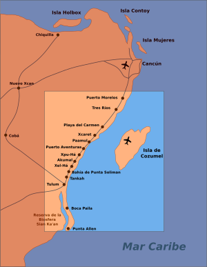
The Riviera Maya is a popular place for tourism and resorts in Mexico. It's located south of Cancun, along the beautiful Caribbean Sea coast. This area is part of the state of Quintana Roo, which is on the eastern side of the Yucatán Peninsula.
The Riviera Maya stretches along a main road called Federal Highway 307. It used to start at Playa del Carmen and end at Tulum. However, now places like Puerto Morelos (north of Playa del Carmen) and Felipe Carrillo Puerto (south of Tulum) are also considered part of this amazing tourist area.
This region was first called the "Cancun–Tulum corridor." But in 1999, it was given the name Riviera Maya. This happened with help from Miguel Ramón Martín Azueta, who was a local leader at the time. The Riviera Maya includes the areas of Solidaridad in the north and Tulum in the south. It also reaches about 40 kilometers (25 miles) inland towards the state of Yucatán.
Contents
Fun Things to Do in Riviera Maya
The Riviera Maya is well-known for its many large all-inclusive resorts. These are places where your food, drinks, and activities are often part of one price. You can also find smaller, unique hotels and many great restaurants. These are located along the main highway and near the beaches.
Many people visit the Riviera Maya for exciting water activities. These activities depend on the beautiful beaches and the clear coastal waters. The Mesoamerican Barrier Reef System is a huge coral reef that starts near Cancun. It runs all the way along the Riviera Maya coast and continues south to Guatemala. This reef system is the second longest in the world!
Some popular activities include jet-skiing, snorkeling, and scuba diving. You can also swim in cool natural pools called cenotes. Other fun things to do are swimming with dolphins, zip-lining, horse riding, and sailing. You can even go on guided tours through the jungle.
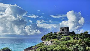
The area is also famous for its ancient archaeological sites. These are places where you can see old ruins from the Maya people. Popular sites include Tulum, which is right on the coast. Further inland, you can visit Chichen Itza and Coba. There are also special "ecoparks" like Xcaret and Xel-Ha. These parks have some smaller ruins, but they are mostly known for their fun water activities. Many people visit them to swim with captive dolphins and enjoy other attractions.
Weather in Riviera Maya
The average temperature in the Riviera Maya is about 24 to 25 degrees Celsius (75 to 77 degrees Fahrenheit). The area has a rainy season from May to November. During the dry season, usually in January and February, there are often strong northerly winds called El Norte.
The Riviera Maya coast gets the most rain in the entire Yucatán Peninsula. It receives about 1500 millimeters (59 inches) of rainfall each year. While the Caribbean coast can experience many tropical storms and hurricanes, these storms often pass north or south of the main Riviera Maya area.
The water in the underground cenotes stays around 25 degrees Celsius (77 degrees Fahrenheit) all year. The ocean water temperatures change a bit. They are about 26 degrees Celsius (79 degrees Fahrenheit) in January and can reach 29 degrees Celsius (84 degrees Fahrenheit) in August.
Riviera Maya's Amazing Landscape
The Riviera Maya is located entirely within the state of Quintana Roo on the Yucatán Peninsula. The land here is mostly flat and covered by a low tropical jungle. The ground is made of very pure limestone, going deep underground.
Even though there's a lot of rain, you won't find any surface rivers here. This is because the water quickly soaks into the ground. The limestone ground has many underground river networks. These have formed over time as water dissolved the rock. You can explore these underground rivers by cave diving through sinkholes, which are called cenotes.
The entire Yucatán Peninsula has a special underground water system. There's a layer of fresh water floating on top of saltier water from the ocean. The amazing caves you see (like in the cenotes) formed where these two types of water meet. By 2008, explorers had mapped over 700 kilometers (435 miles) of flooded cave passages in the Riviera Maya. This includes two of the longest underwater cave systems in the world: Sac Actun and Ox Bel Ha. These underground water sources, found through thousands of cenotes, were vital for the ancient Maya people. Today, they are still the only natural source of drinking water in the area.
The Caribbean coastline has many beautiful white sand beaches shaped like crescents. Every few kilometers, you'll find rocky areas and small inlets called caletas. These are places where the underground fresh water flows out into the ocean. There are also large areas of mangrove swamps behind the beaches. These are important for the environment and are part of the planned tourism development.
Getting to Riviera Maya
Most visitors to the Riviera Maya arrive by flying into Cancún International Airport. This airport is about 50 kilometers (31 miles) north of Playa del Carmen.
There were plans for a new international airport near Tulum. However, as of 2014, those plans were put on hold. Instead, a high-speed train project became the main focus for the area. In 2018, construction began on the Tren Maya. This train will run along the length of the Riviera Maya and connect it to other places on the Yucatán Peninsula.
See also
 In Spanish: Riviera Maya para niños
- Mexican Riviera
- Riviera Nayarit
- Cenote
 | Jessica Watkins |
 | Robert Henry Lawrence Jr. |
 | Mae Jemison |
 | Sian Proctor |
 | Guion Bluford |


