
São José dos Campos facts for kids
São José dos Campos is a big city in the state of São Paulo, Brazil. It's known as a major center for industry and research, especially in aerospace sciences. This means a lot of airplanes and space technology are developed here! The city is located in the Paraíba Valley, between two of Brazil's busiest areas: São Paulo and Rio de Janeiro. It's a main city in the Metropolitan Region of Vale do Paraíba e Litoral Norte. People from São José dos Campos are called joseenses. It's one of the largest non-capital cities in Brazil and is part of a huge connected urban area called the Expanded Metropolitan Complex, which has over thirty million people!
São José dos Campos is home to many important companies like Embraer (a big airplane maker), Johnson & Johnson, General Motors, and Petrobras. It also has great schools and research places, such as the Aeronautics Institute of Technology (ITA) and the National Institute for Space Research (INPE). Because of all these, it's considered the biggest aerospace hub in Latin America. The Technological Park here is the largest in Brazil and is special because it works with top global plane companies like Embraer, Boeing, and Airbus.
Quick facts for kids
São José dos Campos
|
|||
|---|---|---|---|
|
Municipality
|
|||
| Municipality of São José dos Campos | |||
|
From the top, from left to right: view of the city from the Presidente Dutra Highway; Vicentina Aranha Park; Residence of Olívio Gomes in Parque da Cidade; library of the Aeronautics Institute of Technology; Brazilian Aerospace Memorial; Technologic Park; panorama of the Altos da Esplanada region.
|
|||
|
|||
| Nicknames:
Capital of the Valley
and The Airplane Capital |
|||
| Motto(s): | |||

Location in the state of São Paulo and Brazil
|
|||
| Country | |||
| Region | Southeast | ||
| State | |||
| Metropolitan Region | Vale do Paraíba e Litoral Norte | ||
| Area | |||
| • Municipality | 1,099.409 km2 (424.484 sq mi) | ||
| • Urban | 298.99 km2 (115.44 sq mi) | ||
| Elevation | from 619 to 2.082 m (1,970 ft) | ||
| Population
(2022)
|
|||
| • Municipality | 697,054 | ||
| • Density | 634.0261/km2 (1,642.1201/sq mi) | ||
| • Metro | 2,528,354 | ||
| GDP (PPP, constant 2015 values) | |||
| • Year | 2023 | ||
| • Total | $30.0 billion | ||
| Time zone | UTC−3 (BRT) | ||
| Postal Code |
12200-000
|
||
| Area code(s) | +55 12 | ||
| HDI (2010) | 0.807 – very high | ||

.jpg)


.jpg)


Contents
- Exploring the Geography of São José dos Campos
- A Look Back: History of São José dos Campos
- Places to Visit in São José dos Campos
- Fun and Games: Entertainment, Leisure, and Sports
- Learning and Discovery: Education and Research
- Getting Around: Infrastructure
- How the City Makes Money: Economy
- Famous People from São José dos Campos
- Sister City
- Images for kids
- See also
Exploring the Geography of São José dos Campos
City's Size and Surroundings

São José dos Campos covers a total area of about 1,099 square kilometers. A little over 32% of this is urban area, where most people live and work. The rest is rural, with more natural spaces.
The city shares its northern border with Camanducaia and Sapucaí Mirim in Minas Gerais. To the south, it borders Jacareí and Jambeiro in São Paulo State. On its eastern side, you'll find Monteiro Lobato and Caçapava. To the west, it borders Igaratá, Joanópolis, and Piracaia.
Connected Cities: The Metropolitan Area
São José dos Campos is growing so much that it's connecting with nearby cities like Jacareí, Taubaté, and Caçapava. This creates a large connected area called the Paraíba Valley metropolitan area, which includes 39 cities and over 2.4 million people. This big area is also part of an even larger "megalopolis" that links São Paulo and Rio de Janeiro, making it a huge urban region with over 30 million residents.
City Layout and Districts

The city has three main districts: São José dos Campos (the main city), Eugênio de Melo, and São Francisco Xavier. São Francisco Xavier is especially known for its beautiful natural spots and ecotourism.
For easier management, the city is divided into 7 urban regions: Center, North, South, West, East, Southeast, and São Francisco Xavier.
Mountains and Rivers: The City's Landscape
The northern part of São José dos Campos has many highlands, with elevations from about 660 to 975 meters. The very northern edge of the city is on the Serra da Mantiqueira Mountains, where some peaks reach over 2,000 meters. The highest point in the city is 'Pico do Selado', which is 2,082 meters high.
In the city's main urban area, you'll find rolling hills and plateaus. The lowest point in the city is along the Paraíba do Sul River, at about 550 meters above sea level.
The city also has the 'Serra do Jambeiro' mountains to its south, which are about 900 meters high. Because of these different elevations and how the city has grown, different neighborhoods can have slightly different weather. Downtown areas might feel warmer, while suburbs can be cooler. The northern part, especially the Sao Francisco Xavier district, has a cooler, humid subtropical climate due to its higher elevation and preserved natural areas.
The city protects its natural beauty. It includes the São Francisco Xavier Environmental Protection Area and part of the Mananciais do Rio Paraíba do Sul Environmental Protection Area, which helps protect the sources of the Paraiba do Sul River.
São José dos Campos Climate
| Weather chart for São José dos Campos | |||||||||||||||||||||||||||||||||||||||||||||||
|---|---|---|---|---|---|---|---|---|---|---|---|---|---|---|---|---|---|---|---|---|---|---|---|---|---|---|---|---|---|---|---|---|---|---|---|---|---|---|---|---|---|---|---|---|---|---|---|
| J | F | M | A | M | J | J | A | S | O | N | D | ||||||||||||||||||||||||||||||||||||
|
216
29
19
|
191
29
19
|
165
30
18
|
81
27
14
|
59
25
11
|
42
21
9
|
33
20
9
|
33
24
11
|
73
26
12
|
113
28
15
|
134
29
16
|
174
29
18
|
||||||||||||||||||||||||||||||||||||
| temperatures in °C precipitation totals in mm source: Clima dos Municipios Paulistas Cepagri |
|||||||||||||||||||||||||||||||||||||||||||||||
|
Imperial conversion
|
|||||||||||||||||||||||||||||||||||||||||||||||
The climate in São José dos Campos is a mix of different types. It's generally a humid subtropical climate, which means it has warm, humid summers and mild winters. Winters don't get very cold, with average temperatures around 17°C in the coldest month. Summers are pleasant, with average temperatures around 24°C in the hottest month.
It rarely freezes here, maybe once every ten years. However, fog is quite common, especially during winter. The higher mountains to the north can get even colder, and sometimes even see very light snow.
A Look Back: History of São José dos Campos
The story of São José dos Campos began in the late 1500s. At that time, a group called the Jesuits started a cattle farm called Aldeia do Rio Comprido. This farm was a secret religious outpost, like many other Jesuit Reductions in Brazil. They tried to protect local Indigenous people from being enslaved.
In 1611, the area was officially recognized, and farmers were told they couldn't use Natives as slaves. However, conflicts led to the Jesuits being forced out in 1640.
But the Jesuits came back! They started a new settlement where the city center is today. This new spot was higher up, offering safety from attacks and floods. Even though it was a new mission, it was still officially called a cattle farm.
In 1692, the village was called Residência do Paraíba do Sul, and by 1696, it was known as Residência de São José. When gold mining became popular in Brazil, many people left the settlement to find gold, which made things difficult for the village.
In 1759, the Jesuits were permanently expelled from the Portuguese Empire. All their properties, including farms and villages, were taken over by the Portuguese Crown. The governor wanted these places to be productive and bring in more taxes. So, on July 27, 1767, São José officially became a town, called Vila de São José do Paraíba. But for many years, it stayed mostly a rural area.
From Cotton to Coffee
In the mid-1800s, São José do Paraíba started to grow economically thanks to farming. Cotton production quickly increased, and it was sent to English factories. This peaked around 1864.
In the same year, on April 22, the town became the center of a municipality. Finally, in 1871, it got its current name: São José dos Campos. Around the same time, coffee farming started to boom in the Paraíba Valley from 1870.
By 1886, after the Estrada de Ferro Central do Brasil railway opened, coffee production reached its highest point. It then slowly declined until the 1930s.
Healing and Industry

At the beginning of the 20th century, São José dos Campos became known as a place for treating lung diseases like tuberculosis. People believed its climate was very good for health. The city was even called the Sanatorium City. The country's largest hospital at the time, the Vicentina Aranha Sanitarium, opened here in 1924.
However, in the 1940s, new medicines called antibiotics made it possible to treat tuberculosis anywhere. This meant São José lost its special healthcare advantage. But this was also when industries started to arrive!
The city's industrial growth really took off after the Technological Institute of Aeronautics (ITA) was built in 1950. Also, the opening of the Dutra Highway (BR-116) made it much faster to travel between Rio de Janeiro and São Paulo, passing right through São José dos Campos. These changes helped the city become a major scientific and technological hub.
Places to Visit in São José dos Campos
São José dos Campos has many interesting places to see:
- Augusto Ruschi Biological Reserve: A natural area with local plants.
- Burle Marx Municipal Park: A beautiful park with the Olivo Gomes residence.
- CTA and MAB (Brazilian Aerospace Memorial): Places to learn about aerospace technology.
- INPE – (National Institute for Space Research): Where space research happens.
- Sanatorium Vicentina Aranha: A historic hospital building.
- Santos Dumont Park: A large park perfect for relaxing.
Fun and Games: Entertainment, Leisure, and Sports
Even though São José is an industrial city, it still has many green spaces and quiet areas. About 62% of the city's land is protected as an environmental area. The Augusto Ruschi Ecology Reserve, for example, is a large government-protected area for local plants. São Francisco Xavier is another community known for its natural beauty.
It's also easy to visit nearby mountain cities like Campos do Jordão or the beautiful beaches of the Northern Coast of São Paulo, both only about 80 km away.
The city has three big parks and many sports clubs. The Tenis Clube and Associação Esportiva São José have even hosted international tennis tournaments.
The city's professional soccer team, São José Esporte Clube, plays at the Estádio Martins Pereira stadium.
Here are some notable sports teams from the city:
| Club | Sport | Arena | Foundation of the Club | Logo |
|---|---|---|---|---|
| Associação Esportiva São José | Basketball | Ginásio Linneu de Moura | 1913 | |
| Associação Esportiva São José | Swimming | Ginásio Linneu de Moura | 1913 | |
| São José Esporte Clube | Football | Estádio Martins Pereira | 1933 | |
| Tenis Clube São José | Basketball | Ginásio Municipal José Edvar Simões | 1948 | |
| Tenis Clube São José | Volleyball | Ginásio Esportivo Manoel Bosco Ribeiro | 1948 | |
| São José Rugby Clube | Rugby union | Estádio Martins Pereira | 1987 | |
| Clube Atlético Joseense | Football | Estádio Martins Pereira / Estádio ADC Parahyba | 1998 | |
| Scott–Marcondes Cesar–São José dos Campos | Cycling | n/a | 1993 | N/a |
| São José/Vale Sul Futsal | Indoor soccer/Futsal | Tenis Clube São José | na | n/a |
| FC Primeira Camisa | Football | Estádio ADC Parahyba | 2007 |
The city also has 19 movie theaters and 7 theaters, including one at the Univap.
Learning and Discovery: Education and Research

São José dos Campos is a hub for learning and research. The Brazilian National Institute for Space Research (INPE) has its main office here. They do a lot of important work in areas like Earth observation, space science, and space technologies. The Brazilian General Command for Aerospace Technology (CTA) also has facilities in the city. There are many schools, from preschools to high schools, and several universities.
Universities and Colleges
Some of the universities and colleges in São José dos Campos include:
- Unip
- Unifesp
- Univap
- UNESP
- Fatec
- ITA (a very famous engineering school)
Research Centers
Key research centers in the city are:
- INPE – The Brazilian National Institute for Space Research
- Brazilian General Command for Aerospace Technology (CTA) and its institutes, which focus on aerospace and advanced studies.
Getting Around: Infrastructure
Transportation

The city has two bus stations that connect it to cities all over Brazil and even to other countries like Argentina and Chile. São José dos Campos also has a big local bus system and minivans to help people get around.
The city has a system of ring roads that connect it to important highways:
- BR-116 (Presidente Dutra Highway): This federal highway goes through the city and is used a lot for daily travel.
- SP-070 (Rodovia Carvalho Pinto): Connects São Paulo to Taubaté.
- SP-065: Connects São Jose dos Campos to Campinas.
- SP-099 (Rodovia dos Tamoios): Connects São José to the coast, leading to cities like Caraguatatuba.

- SP-050: An older road that connects São José dos Campos to Campos do Jordão and parts of Minas Gerais.
There's also a railway, but it's only used for carrying goods now. The ports of São Sebastião and Santos are easily reached by highway, which is important for trade.

The São José dos Campos Airport (SJK) is busy, especially with business travelers. It's an important link between São Paulo and Rio de Janeiro. The airport also helps people visit the tourist city of Campos de Jordão. It's used for transporting goods from the many industries in the area.
São José dos Campos also gets natural gas through pipelines, and big companies like General Motors and Embraer use it. The city is one of the largest in Brazil for natural gas distribution to homes.
Communication
The city has a large network of fiber optics, providing broadband internet services to most of the city. There are also many cell phone services available.
How the City Makes Money: Economy
Farming and Agriculture
Farmers in São José dos Campos grow various crops like rice, tomatoes, potatoes, and oranges. They also raise cattle for meat and milk, and produce eggs and chicken.
Industry

São José dos Campos has changed a lot from a rural town to an important manufacturing center. There are over 1,251 industries in the city, employing nearly 49,000 people. The main industries are automotive (cars), oil/petrochemical (oil products), and aerospace (airplanes and space). You'll also find companies making pharmaceuticals, consumer durables (like appliances), chemicals, and telecommunication equipment.
The city is often called the "Brazilian aeronautics capital" because it's home to CTA and Embraer, one of the biggest aircraft manufacturers in the world.
In 2014, São José dos Campos was the 5th largest exporter among all Brazilian cities. Most of its exports were aircraft and aircraft parts, showing how important the aerospace industry is here.
Services and Technology
Since the 1990s, the city's economy has shifted. Many manufacturing jobs have been replaced by jobs in the service and technology industries.
For example, the Chacaras Reunidas Entrepreneurial District has many small and medium-sized companies that provide services.
The city has two technological parks and five business incubators (places that help new companies start up) connected to universities or industrial facilities. These incubators help new technology companies in areas like materials, electronics, information technology, aerospace, and biotechnology.
Because of its location, São José dos Campos has become an important center for logistics, which involves managing how goods are moved and stored. This has created many jobs in purchasing, transport, and warehousing.
Shopping and real estate have also grown a lot. The city is a major shopping and service hub for the entire Vale do Paraíba region, the northern coast of São Paulo, and southern Minas Gerais.
Shopping Areas
You can find all the major supermarkets, department stores, and shopping malls in São José dos Campos. The biggest malls are:
- CenterVale Shopping
- Shopping Colinas
- Vale Sul Shopping
- Shopping Jardim Oriente
There are also popular street shopping areas like Rua Sete de Setembro – Calçadão and Rua XV de Novembro in the downtown area. The Municipal Market is a great place for groceries and local stores.
Newer shopping and dining areas include Avenida Nove de Julho (for fashion and restaurants) and Avenida São João (with boutiques, restaurants, and schools). The Vila Ema district is known for its nightlife, with many bars and restaurants.
Famous People from São José dos Campos
- Casemiro (Football player)
- Yuri Alberto (Football player)
- Ricardo Goulart (Football Player)
- Fabíola Molina (Swimmer)
- Maisa Silva (Actress, singer)
- André de Azevedo (Rally driver)
- Leonardo Cordeiro (Racing driver)
- Cassiano Ricardo (poet)
- Pamela Rosa (Skateboarder)
Sister City
São José dos Campos has a special connection with Kadoma, Osaka in Japan. There's even a Japanese garden in Santos-Dumont Park that celebrates this friendship!
Images for kids
-
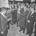
Inauguration of the General Motors Factory in São José dos Campos by President Juscelino Kubitschek, 1959.
See also
 In Spanish: São José dos Campos para niños
