
STS-59 facts for kids

Space Shuttle Endeavour in orbit with SIR-C in its payload bay
|
|
| Mission type | Radar imaging |
|---|---|
| Operator | NASA |
| Mission duration | 11 days, 5 hours, 49 minutes, 30 seconds |
| Distance travelled | 7,571,762 kilometers (4,704,875 mi) |
| Orbits completed | 183 |
| Spacecraft properties | |
| Spacecraft | Space Shuttle Endeavour |
| Payload mass | 12,490 kilograms (27,540 lb) |
| Crew | |
| Crew size | 6 |
| Members |
|
| Start of mission | |
| Launch date | 9 April 1994, 11:05 UTC |
| Launch site | Kennedy LC-39A |
| End of mission | |
| Landing date | 20 April 1994, 16:55 UTC |
| Landing site | Edwards Runway 22 |
| Orbital parameters | |
| Reference system | Geocentric |
| Regime | Low Earth |
| Perigee | 194 kilometres (121 mi) |
| Apogee | 204 kilometres (127 mi) |
| Inclination | 57 degrees |
| Period | 88.4 min |
  Left to right - Standing: Chilton, Gutierrez; Seated: Godwin, Jones, Apt, Clifford |
|

STS-59 was a Space Shuttle mission that happened in 1994. The main goal was to use special radar equipment to study Earth. This mission was even featured in a Discovery Channel TV special about the Space Shuttle program.
Contents
- Meet the Astronauts: STS-59 Crew
- Mission Highlights: Exploring Earth from Space
- Day 1: Launch and Radar Activation (April 9)
- Day 2: First Targets and Supersites (April 10)
- Day 3: Radar Images and Student Collaboration (April 11)
- Day 4: Andes Mountains and Water Troubles (April 12)
- Day 5: Contact with Mir and Exercise (April 13)
- Day 6: Fire Scars and Public Outreach (April 14)
- Day 7: Pollution and Ground Support (April 15)
- Day 8: More Radio Calls and Observations (April 16)
- Day 9: Earth's Environment and Landing Prep (April 17)
- Day 10: Packing Up and Weather Watch (April 18)
- Day 11: Landing Delay and Data Volume (April 19)
- Day 12: Successful Landing (April 20)
- Mission Patch: What Do the Symbols Mean?
- Images for kids
Meet the Astronauts: STS-59 Crew
The STS-59 mission had a team of six skilled astronauts. They worked together to operate the advanced radar instruments and gather important data about our planet.
| Position | Astronaut | |
|---|---|---|
| Commander | Sidney M. Gutierrez Second and last spaceflight |
|
| Pilot | Kevin P. Chilton Second spaceflight |
|
| Mission Specialist 1 | Jay Apt Third spaceflight |
|
| Mission Specialist 2 | Michael R. Clifford Second spaceflight |
|
| Mission Specialist 3 | Linda M. Godwin Second spaceflight |
|
| Mission Specialist 4 | Thomas D. Jones First spaceflight |
|
Mission Highlights: Exploring Earth from Space
The STS-59 mission lasted for 11 days. During this time, the crew used powerful radar tools to map and study different parts of Earth. They looked at land, oceans, and even the air around us.
Day 1: Launch and Radar Activation (April 9)

The Space Shuttle Endeavour launched right on time on April 9, 1994. Soon after, the astronauts started setting up the radar equipment in the shuttle's cargo bay. This equipment would work non-stop for the next ten days.
By evening, the Space Radar Laboratory-1 (SRL-1) experiments were active. These experiments were part of NASA's "Mission to Planet Earth," which studies our planet's ecosystem.
The team on the ground started getting the first radar images from the Spaceborne Imaging Radar-C (SIR-C). There was a small issue with the X-Band Synthetic Aperture Radar (X-SAR) at first. Engineers fixed it by bypassing a sensitive circuit, and then it worked perfectly.
Another instrument, the Measurement of Air Pollution from Satellite (MAPS), also began collecting data. It measured how much carbon monoxide was in the atmosphere.
Day 2: First Targets and Supersites (April 10)
On Sunday morning, the radar lab had already collected data from over 40 places. These included areas like Howland, Maine, the Black Sea, and the Strait of Gibraltar.
Scientists also focused on "supersites," which were top-priority areas. They gathered information on global carbon and water cycles in Duke Forest, North Carolina. They also studied geology around Lake Chad in the Sahara Desert.
The MAPS instrument continued to measure carbon monoxide levels. The astronauts also took great photos of the Earth, including fires in the mountains of Mexico.
The crew worked in shifts to keep the experiments going around the clock.
Day 3: Radar Images and Student Collaboration (April 11)
On Monday morning, Endeavour sent down three real-time radar images. One showed the Sahara Desert in Algeria, helping scientists map its surface and underground structures.
The radar systems were also calibrated over Matera, Italy, and Oberpfaffenhofen, Germany. Students from the University of Munich helped by measuring soil moisture and plant growth on the ground at the same time.
Astronaut Thomas D. Jones observed thunderstorms over Taiwan and the Philippines. Jay Apt described a "good-sized" dust storm off the coast of Australia.
Later that day, more images came down, including one of the area around Japan. The quick-look processor even showed possible oil slicks in the ocean.
The crew also had a small problem with air bubbles in their drinking water supply.
Day 4: Andes Mountains and Water Troubles (April 12)
On Tuesday, an image from the X-SAR showed a region of the Andes Mountains in Bolivia. The radar also collected images of oceans, mountains, and forests.
The astronauts worked on fixing the water bubble problem. They connected the water hose directly to the tank. Even with this fix, some bubbles still got into their drink bags.
Live X-SAR images were sent down of Sarobetsu, Japan. Scientists on the ground measured the radar signal strength there. They were also working on creating maps of Japan and finding the best way to use the radar for mapping rice fields.
Astronaut Linda M. Godwin reported clear views for photography over Chickasha, Oklahoma. She also saw sea ice along the coast of Russia.
Day 5: Contact with Mir and Exercise (April 13)
On Wednesday, the astronauts continued their work. Researchers saw live radar images of the Namib Desert in South Africa. These images helped them understand how radar signals bounce off different surfaces. They also viewed sea ice off Siberia and areas of drought in the Sudan.
Astronaut Jay Apt talked to Russian cosmonauts on the Mir space station using amateur radio. The two spacecraft were about 2,200 kilometers (1,200 miles) apart.
The astronauts also exercised on a special bicycle. This was part of a study to see how exercise helps astronauts stay healthy in space. The water bubble problem was mostly solved with a makeshift seal.
Day 6: Fire Scars and Public Outreach (April 14)
On Thursday, astronaut Rich Clifford answered questions from radio listeners about spaceflight and life on the Space Shuttle.
The crew took photos of a huge area in China that had burned in a fire in 1987. This was important for studying how forests regrow after fires.
Jay Apt had some time off and exercised. The X-SAR team also produced video images of the Chickasha site, which helped hydrologists study soil moisture.
Day 7: Pollution and Ground Support (April 15)
On Friday, astronaut Tom Jones noted that a pollution cloud over Manila Bay in the Philippines was almost gone. He also saw fires in Myanmar and smoke over Tasmania.
One of the instruments, MAPS, ran out of infrared film.
Astronaut Kevin Chilton explained how a large network of scientists on the ground helped with the radar observations. Linda Godwin answered questions from CNN viewers. The crew continued to deal with the minor issue of bubbles in their water supply.
Day 8: More Radio Calls and Observations (April 16)
On Saturday, Jay Apt used the Shuttle Amateur Radio again. He talked to fellow astronauts and two Russian cosmonauts at the Star City training center near Moscow.
The crew reported seeing fires in Africa and thunderstorms over northeastern Brazil. Scientists asked them to photograph Rugen Island off Germany's coast.
All the Space Radar Lab-1 instruments were working well. They had already observed all the planned sites at least once. Any new observations were to add more data. The water bubble problem was finally solved!
Linda Godwin gave interviews to TV reporters in Atlanta and Nashville.
Day 9: Earth's Environment and Landing Prep (April 17)
On Sunday, the crew continued to record radar images. These images help scientists understand how Earth's land, water, and living things work together to create our planet's environment.
The crew also checked the shuttle's flight controls and thruster jets. This was to make sure everything was ready for landing.
Three astronauts, Gutierrez, Chilton, and Jones, took part in a religious service. The mission's six astronauts also held a news conference, answering questions about their important work.
Day 10: Packing Up and Weather Watch (April 18)
On Monday, the Endeavour crew started packing up. They made final radar observations as the mission neared its end. They were aiming for a landing in Florida the next day.
The weather forecast for Florida looked good, but flight controllers were watching for low clouds and possible rain.

Day 11: Landing Delay and Data Volume (April 19)
On Tuesday, clouds and strong winds at the Kennedy Space Center meant Endeavour had to stay in space for an extra day.
After the delay, the crew set up the shuttle systems for another day in orbit. They also reactivated part of the Space Radar Laboratory. Only the Space Imaging Radar system (SIR-C) was turned back on.
The data collected during the STS-59 mission was huge! It would fill the equivalent of 20,000 encyclopedia volumes. The mission mapped over 70 million square kilometers of Earth's surface, which is about 12 percent of the planet. The radar images covered about 25 percent of Earth's land surfaces.
Day 12: Successful Landing (April 20)
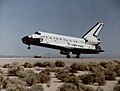
On Wednesday, April 20, 1994, Endeavour landed safely at Edwards Air Force Base in California. This marked the successful end of its 11-day mission.
Mission Patch: What Do the Symbols Mean?
The STS-59 mission patch has five stars on the left and nine stars on the right. These stars show the mission's number, 59, in the Space Transportation System's mission order.
Images for kids
-
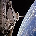
Space Shuttle Endeavour in orbit with SIR-C in its payload bay
-
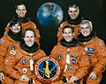
Left to right - Standing: Chilton, Gutierrez; Seated: Godwin, Jones, Apt, Clifford
-
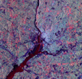
Washington, D.C. as seen by SIR–C/X–SAR imaging radar.
-
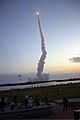
STS-59 launches from Kennedy Space Center, 9 April 1994.
-
STS-59 lands at Edwards AFB in California.
