Sheridan County, Montana facts for kids
Quick facts for kids
Sheridan County
|
|
|---|---|

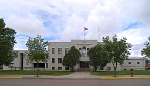
Sheridan County Courthouse in Plentywood
|
|

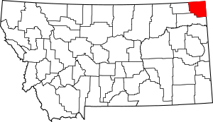
Location within the U.S. state of Montana
|
|
 Montana's location within the U.S. |
|
| Country | |
| State | |
| Founded | March 11, 1913 |
| Named for | Philip Sheridan |
| Seat | Plentywood |
| Largest city | Plentywood |
| Area | |
| • Total | 1,706 sq mi (4,420 km2) |
| • Land | 1,677 sq mi (4,340 km2) |
| • Water | 29 sq mi (80 km2) 1.7% |
| Population
(2020)
|
|
| • Total | 3,539 |
| • Estimate
(2022)
|
3,564 |
| • Density | 2.0744/sq mi (0.8009/km2) |
| Time zone | UTC−7 (Mountain) |
| • Summer (DST) | UTC−6 (MDT) |
| Congressional district | 2nd |
|
|
Sheridan County is a county located in the state of Montana. In 2020, about 3,539 people lived there. The main town, or county seat, is Plentywood. The county's northern edge touches the border with Canada, specifically the province of Saskatchewan.
Contents
History of Sheridan County
The Montana state government created Sheridan County in 1913. It was formed from parts of Dawson and Valley Counties. The county was named after American Civil War General Philip Sheridan.
In the 1920s and 1930s, Sheridan County saw a lot of activity from people who supported communist ideas. The CPUSA (Communist Party USA) even had some of its members elected to local town and county jobs. In the 1932 presidential election, the communist candidate, William Z. Foster, received 576 votes, which was 22% of the total. Later, as communist groups changed their plans, especially by forming "popular fronts" (working with other political groups), their influence in the area decreased.
Geography of Sheridan County
Sheridan County covers a total area of about 1,706 square miles. Most of this area, 1,677 square miles, is land. The remaining 29 square miles, or 1.7%, is water.
Main Roads in Sheridan County
Neighboring Areas
Sheridan County shares its borders with several other counties and rural areas:
- Rural Municipality of Happy Valley, Saskatchewan – to the northwest
- Rural Municipality of Surprise Valley, Saskatchewan – to the north
- Rural Municipality of Lake Alma, Saskatchewan – to the northeast
- Daniels County – to the west
- Divide County, North Dakota – to the east
- Williams County, North Dakota – to the east
- Roosevelt County – to the south
Protected Natural Areas
Part of the Medicine Lake National Wildlife Refuge is located within Sheridan County. This refuge helps protect wildlife and their habitats.
Population and People
| Historical population | |||
|---|---|---|---|
| Census | Pop. | %± | |
| 1920 | 13,847 | — | |
| 1930 | 9,869 | −28.7% | |
| 1940 | 7,814 | −20.8% | |
| 1950 | 6,674 | −14.6% | |
| 1960 | 6,458 | −3.2% | |
| 1970 | 5,779 | −10.5% | |
| 1980 | 5,414 | −6.3% | |
| 1990 | 4,732 | −12.6% | |
| 2000 | 4,105 | −13.3% | |
| 2010 | 3,384 | −17.6% | |
| 2020 | 3,539 | 4.6% | |
| 2022 (est.) | 3,564 | 5.3% | |
| U.S. Decennial Census 1790–1960, 1900–1990, 1990–2000, 2010–2020 |
|||
2020 Census Information
According to the 2020 census, 3,539 people lived in Sheridan County.
2010 Census Information
In 2010, there were 3,384 people living in the county. The population density was about 2 people per square mile. Most residents were white (95.4%), with smaller groups of American Indian (1.7%), Asian (0.4%), and Black or African American (0.2%) people. About 1.5% of the population was of Hispanic or Latino origin.
Many families in the county had Norwegian (33.8%), German (26.0%), or Danish (12.0%) backgrounds. The average age of people living in Sheridan County was 50.3 years old.
Towns and Communities
City
- Plentywood (This is the county seat, meaning it's where the main county government offices are located.)
Towns
Smaller Communities
These are places that are not officially incorporated as cities or towns:
Former Towns
- Dooley
- Archer
Census-Designated Places
These are areas that are identified by the U.S. Census Bureau for statistical purposes:
See also
 In Spanish: Condado de Sheridan (Montana) para niños
 | May Edward Chinn |
 | Rebecca Cole |
 | Alexa Canady |
 | Dorothy Lavinia Brown |

