
Solomon Creek facts for kids
Quick facts for kids Solomon Creek |
|
|---|---|

Solomon Creek in wintertime
|
|
| Physical characteristics | |
| Main source | Fairview Township, Luzerne County, Pennsylvania 1,840 ft (560 m) 41°10′46″N 75°51′59″W / 41.179478°N 75.866441°W |
| River mouth | Susquehanna River at Hanover Township, Luzerne County, Pennsylvania 594 ft (181 m) 41°13′24″N 75°57′14″W / 41.2234°N 75.9539°W |
| Length | 8.5 mi (13.7 km) |
| Basin features | |
| Progression | Susquehanna River, Chesapeake Bay |
| Basin size | 18.1 sq mi (47 km2) |
| Tributaries |
|
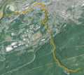
Solomon Creek is a stream in Luzerne County, Pennsylvania. It flows into the Susquehanna River. The creek is about 8.8 miles (14.2 km) long. It passes through Fairview Township, Hanover Township, and Wilkes-Barre.
The creek has been affected by pollution from old mines. This pollution is called acid mine drainage. It adds iron, aluminum, and manganese to the water. Solomon Creek has three main streams that flow into it: Spring Run, Sugar Notch Run, and Pine Creek. The area around Solomon Creek is part of the Anthracite Valley. This region is known for its coal.
Native Americans first lived near Solomon Creek a very long time ago, around 8000 to 6000 B.C.E. European settlers arrived by 1774. In the 1800s, more people came to the area. They wanted to use the natural resources, especially coal. Coal mining was very common in the 19th and 20th centuries. This mining changed or destroyed many small streams. It also caused the Laurel Run mine fire.
In the 1970s, there were no fish in Solomon Creek. But now, different types of fish live there, including brook trout. Many kinds of water insects also live in the creek.
Contents
Where Does Solomon Creek Flow?

Solomon Creek begins on the western side of Penobscot Mountain. This is in northern Fairview Township. It flows west down the mountain for a short distance. Then it turns north. It runs next to Pennsylvania Route 309 and briefly Pennsylvania Route 437.
The creek then enters Hanover Township. Here, Pine Creek joins it. Solomon Creek then cuts through Wilkes-Barre Mountain and passes through Ashley. After Ashley, it flows into Wilkes-Barre. Sugar Notch Run and Spring Run join the creek here.
The creek soon turns west and goes back into Hanover Township. By this point, it has flowed about 6 miles (9.7 km). Finally, it flows into the Susquehanna River at Hanover Green.
What Streams Join Solomon Creek?
Solomon Creek has three main tributaries: Sugar Notch Run, Pine Creek, and Spring Run. Sugar Notch Run is about 3.46 miles (5.57 km) long. Pine Creek is about 7.68 miles (12.36 km) long. Spring Run is about 2.93 miles (4.72 km) long. Spring Run sometimes dries up.
There are also two other small streams that don't have official names. Locals call them Sulfur Run and the Lee Park tributary. In the past, Solomon Creek had at least seven tributaries. But many of them disappeared by the late 1890s because of mining.
How Healthy is Solomon Creek's Water?
Solomon Creek often looks orange when it flows past Wilkes-Barre. This color comes from acid mine drainage. This is water that flows out of old mines.
Some of the smaller streams that feed Solomon Creek lose water when they flow over underground mine pools. For example, Spring Run loses about 75% of its water this way. The amount of water flowing in the creek is usually about 3.39 cubic feet per second. The highest amount of water ever recorded was 2450 cubic feet per second in 1955.
The water in Solomon Creek contains different metals from the mines.
- Aluminum: The amount of aluminum in the creek can be from 8.8 pounds (4.0 kg) to 87.9 pounds (39.9 kg) per day.
- Iron: The amount of iron can be from 0 pounds (0 kg) to 9,624 pounds (4,365 kg) per day. Two major sources of iron pollution in the Coal Region are in this watershed.
- Manganese: The amount of manganese can be from 0.7 pounds (0.32 kg) to 1,086 pounds (493 kg) per day.
The water can also be acidic. The acidity can range from 0 to 1,506.1 pounds (683.2 kg) per day.
In 2011, the water temperature in the watershed ranged from 34 °F (1 °C) to 70 °C (158 °F). The water's pH (how acidic or basic it is) ranged from 4.5 (acidic) to 7.5 (closer to neutral). The amount of iron in the water varied greatly. The amount of dissolved oxygen (oxygen fish need to breathe) also varied. Some areas had no oxygen at all.
There are six places in the Solomon Creek area where polluted mine water flows out. This mine drainage makes about 10 miles (16 km) of streams in the watershed unable to support life.
The water level of Solomon Creek has gone up since the mid-1800s. There is also a lot of sediment (dirt and small rocks) along the creek. In some places, these piles of sediment are over 3 feet (0.91 m) high. Sewage also flows into the creek in several spots. This has been happening since at least 1909. There are also piles of trash and debris in the creek.
What is the Land Around Solomon Creek Like?
Solomon Creek is located in the ridge and valley area. This is part of the Anthracite Valley. There is a ridge in the creek's watershed called Wilkes-Barre Mountain. This mountain has rocks like red shale, sandstone, and siltstone. Other important rock types include olive and gray rocks.
The watershed is part of the Wyoming Coal Basin. This area was shaped by glaciers during the last ice age. At the start of Spring Creek, there is a rock formation called Prospect Rock. It is 1,394 feet (425 m) above sea level.
The highest point in the watershed is 2,148 feet (655 m) on Haystack Mountain. The lowest point is 560 feet (170 m). The creek's mouth (where it meets the Susquehanna River) is 594 feet (181 m) above sea level. The creek's source is almost 1,840 feet (560 m) above sea level.
There are 14 coal seams (layers of coal) in the Solomon Creek watershed. Some of these coal layers were very close to the surface. But they have all been mined out. Areas along the creek banks are covered in coal ash, coal silt, sand, and gravel. The lower parts of the creek have sand and gravel bars.
In the Solomon Gap, there are large piles of coal ash. These piles are pink and orange because of oxidation. They can be as tall as 100 feet (30 m). Similar colored coal is found in the creek's sediment.
What Kind of Soil is Near the Creek?
In the Pennsylvania State Game Lands Number 207 (a protected area), the soil is called Arnot Rock outcrop complex. On steep hills, this soil is dark brown silt loam. It has bedrock about 12 inches (30 cm) deep. Water runs off it quickly, and 3% to 40% of the surface is covered with large rocks called boulders. On less steep slopes, the bedrock is about 18 inches (46 cm) deep, and water runs off slower.
What is the Solomon Creek Watershed Like?
The area that drains into Solomon Creek, called its watershed, is 18.2 square miles (47 km2).
About 60% of the watershed is forest land. About 26% is developed land (like towns and cities). Nearly 7% of the land has been disturbed by things like old coal mines and quarries. For example, there are 6748 acres of forest and 1174 acres of "high-intensity development." There are also farms, wetlands, and active coal mines. The watershed has about 26.66 miles (42.91 km) of streams. Much of the southern part of the watershed is covered in deciduous forest (trees that lose their leaves). Most of the farmland is near the creek's mouth.
Nine towns and townships are partly in the Solomon Creek watershed. Most of the watershed is in Ashley, Laurel Run, Wilkes-Barre Township, and Hanover Township. Smaller parts are in Wilkes-Barre, Bear Creek Township, Fairview Township, Rice Township, and Sugar Notch.
In 2000, about 4269 people lived in the Solomon Creek watershed. There are more people over 65 years old in this area than average. Major roads like Interstate 81 and Pennsylvania Route 309 pass through the watershed.
The Solomon Creek watershed is divided into five smaller areas: the upper and lower Solomon Creek watershed, the Pine Creek watershed, the Spring Run watershed, and the Sugar Notch Run watershed. Nearby watersheds include those of Little Wapwallopen Creek and Big Wapwallopen Creek.
A Look Back at Solomon Creek's History

Native Americans lived in the Solomon Creek area as early as 8000 to 6000 B.C. The creek is named after a settler named Solomon, who arrived in 1774. In the early 1800s, people started to discover the natural resources here. The population grew a lot in the mid-1800s because of coal mining and logging. The first road in Fairview Township started at Solomon Creek.
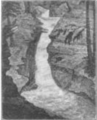
There were once beautiful waterfalls called Solomon's Falls on the creek. In 1809, they were described as a "beautiful cascade." But by 1909, they were no longer considered "picturesque." The falls were between 50 feet (15 m) and 60 feet (18 m) high.
In 1809, a gristmill (a mill for grinding grain) was built at the falls. It was later destroyed. Other mills were built on the creek too, but they also disappeared over time. The Wyoming Division Canal started at Solomon Creek in the 1830s. The Ashley Planes, a special railway system, were built in the Solomon Creek gap starting in 1837. They were used to move coal.
An iron-making factory and a sawmill also operated on the creek. A powder mill (for making gunpowder) was replaced by a brewery by 1885. In the early 1900s, a slaughterhouse released its waste into the creek. The creek was also used to supply water for the Huber Breaker, a coal processing plant, from the 1930s to the 1970s.
Mining caused a lot of environmental damage in the Solomon Creek watershed. Mining started in the early 1800s and continued until the 1970s. In 1967, water stopped being pumped out of the underground mine pools. This caused them to flood. In 1972, during Hurricane Agnes, this flooding damaged buildings. To fix this, the Buttonwood Tunnel and three boreholes (deep holes) were created to drain the water.
A mine fire called the Laurel Run mine fire has been burning in the Solomon Creek watershed since 1915. It started when a miner accidentally left a lamp hanging from a wooden support, which caught fire. This fire is still burning underground and might continue for a long time. It burns at about 1,000 °F (538 °C).
The creek has flooded many times. In September 1850, it had its most severe flood up to that point. In January 1996, 400 buildings along the creek flooded because of melting snow.
What Are Other Names for Solomon Creek?
Locals have also called Solomon Creek "Chester Creek." On maps from the 1770s, it was called "Moses Creek." This name might have come from a Native American person.
Animals and Plants in Solomon Creek

In 1975, a study found no fish in Solomon Creek. But now, brook trout have been seen in seven places along the creek. They are very common in Sugar Notch Run. Trout also reproduce in Pine Creek and in the main part of Solomon Creek.
Other fish species have been seen upstream of the South Wilkes-Barre borehole. These include eastern blacknose dace, bluegill, creek chub, fallfish, minnows, northern hog sucker, and white sucker. However, no fish live downstream of the borehole.
Many types of macroinvertebrates (small water creatures without backbones) live in the creek. These are important food for fish. About 2.6 stream miles in the watershed are good for brook trout fisheries.
Aquatic Insects and Their Life Cycle
The most common aquatic insects at the start of healthy streams in the watershed are alderflies, caddis flies, dragonflies, mayflies, and stoneflies. These insects are a sign of good water quality.
Fun Things to Do Near Solomon Creek
The Pennsylvania State Game Lands Number 207 are in the southeastern part of the Solomon Creek Watershed. This is a large area for outdoor activities. Parts of Pinchot State Forest are also in the watershed.
Two trails in the Sugar Notch Trail System are located near Sugar Notch Run. The creek is also stocked with trout in some places, which means fish are added for people to catch. There are also ATV trails in the watershed for riding.
Images for kids
-

Solomon Creek in wintertime
-
Satellite map of Solomon Creek
-
1809 woodcut of the Solomon Creek falls
-

An Appalachian brook trout
