
St. Croix River (Maine–New Brunswick) facts for kids
Quick facts for kids St. Croix River |
|
|---|---|

St. Croix River at
Vanceboro, Maine. |
|
| Country | Canada/United States |
| Physical characteristics | |
| Main source | Chiputneticook Lakes |
| River mouth | Passamaquoddy Bay sea level 45°04′23″N 67°05′35″W / 45.073°N 67.093°W |
| Basin features | |
| Basin size | 1,500 square miles (3,900 km2) |

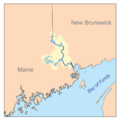
The St. Croix River (which is Fleuve Sainte-Croix in French) is a river in northeastern North America. It is about 71 miles (114 km) long. This river forms part of the border between Maine in the United States and New Brunswick in Canada.
The St. Croix River starts in the Chiputneticook Lakes. It then flows south and southeast, passing between the towns of Calais and St. Stephen. Finally, it empties into Passamaquoddy Bay, which is part of the larger Bay of Fundy.
Contents
Exploring the St. Croix River's Geography
The St. Croix River begins in a group of lakes called the Chiputneticook Lakes. These include North Lake, East Grand Lake, Mud Lake, and Spednic Lake. These lakes are located right along the border between Canada and the United States.
Maps from the United States Geological Survey show that the St. Croix River officially starts from a stream that flows out of East Grand Lake. This stream is about 1.0-mile-long (1.6 km). It then goes through Mud Lake and into Spednic Lake. Spednic Lake is about 20 miles (32 km) long. The river then flows out of Spednic Lake near Vanceboro, Maine. If you add the length of the river and lakes from East Grand Lake, the total length of the St. Croix River is about 95 miles (153 km).
The entire area that drains water into the St. Croix River is about 1,500 square miles (3,900 km2). This is called its drainage basin. In the 1900s, many hydroelectric power plants were built along the river. These plants use the river's water to create electricity.
The river used to have many Atlantic salmon. However, building dams upstream from Calais and St. Stephen reduced the number of salmon. This happened because the dams made it harder for the salmon to swim upstream to lay their eggs.
Between Calais-St. Stephen and its mouth at Robbinston and St. Andrews, the river becomes an estuary. This means it's a place where fresh river water mixes with salty ocean water. This tidal area is about 16 miles (26 km) long. It even has a tidal bore, which is a wave that travels up the river as the tide comes in.
How People Used the River for Travel and Trade
The Saint Croix River was very important for trade a long time ago. It was an early pathway for people to travel and move goods between the Atlantic coast and the inner parts of Maine and New Brunswick. Large ocean ships could sail upstream all the way to Calais and St. Stephen. However, the changing tides made Eastport a better port for bigger ships.
Upstream from Calais and St. Stephen, the river became a key route for log driving. This was how wooden logs and pulpwood were floated down from the forests. These logs were used by sawmills and paper mills. These mills were built in places like Calais and Woodland to use the river's water power.
The St. Croix River and Old Border Disputes
The St. Croix River was at the center of border problems after the Treaty of Paris (1783) was signed in 1783. At that time, maps of the river were not very clear. The Jay Treaty in 1794 helped by setting up plans to survey the border more accurately.
It took another 40 years to figure out the border between Maine and New Brunswick. This was the area north of the St. Croix River, in the Saint John River watershed. After the War of 1812, there was a strong push to settle this disputed land. The border was finally agreed upon in 1842.
During this time, Maine, Massachusetts, and New Brunswick all gave out permits for cutting timber in the disputed area. Many lumbermen, with or without permits, rushed to cut the best trees. Even though it was against the law to cut trees without a permit, officials in New Brunswick often looked the other way. This was because the timber trade helped local mills, shipyards, and timber businesses.
The lumbermen were very competitive about getting the best trees. They would try to claim trees they found first. Sometimes, they even used Dynamite to blow up log booms. Log booms were chains of logs used to catch cut trees floating down the river. It is also known that timber workers sometimes mixed up their logs on purpose. This was to try and confuse officials who were trying to control the timber trade.
Monitoring Water Levels on the St. Croix River
Scientists keep a close eye on the water levels and flow of the St. Croix River. This helps them understand the river's health and how it changes.
Monitoring in Canada
The Water Survey of Canada has six river flow gauges in the St. Croix River area. These gauges measure how much water is flowing.
- St. Croix, New Brunswick (45°34′08″N 67°25′47″W / 45.5689°N 67.4297°W)
- Baring, Maine (45°08′12″N 67°19′05″W / 45.1367°N 67.3181°W)
- Dennis Stream near St. Stephen, New Brunswick (45°12′35″N 67°15′45″W / 45.2097°N 67.2625°W)
- East Grand Lake at Forest City, New Brunswick (45°39′54″N 67°44′10″W / 45.6650°N 67.7361°W)
- Spednic Lake at St. Croix, New Brunswick (45°34′09″N 67°25′41″W / 45.5692°N 67.4281°W)
- Forest City Stream, below the Forest City Dam at Forest City, New Brunswick (45°39′51″N 67°44′04″W / 45.6642°N 67.7344°W)
Monitoring in the United States
The United States Geological Survey (USGS) has two river flow gauges in the St. Croix River area.
- Vanceboro, Maine (45°34′08″N 67°25′47″W / 45.56889°N 67.42972°W). Here, the river's drainage area is 413 square miles (1,070 km2). This spot is 400 feet (100 m) downstream from the Spednic Lake Dam.
- Baring Plantation, Maine (45°34′08″N 67°25′47″W / 45.56889°N 67.42972°W). The drainage area here is 1,374 square miles (3,559 km2). This location is 5.6 miles (9.0 km) downstream from the closest dam. The highest water flow recorded here was 23,500 cubic feet (670 m3) per second. The lowest was 262 cubic feet (7.4 m3) per second.
The USGS also checks the water chemistry at Milltown, Maine (45°10′11″N 67°17′50″W / 45.16972°N 67.29722°W). The drainage area at this point is 1,455 square miles (3,768 km2). In the year 2001, the pH (which tells you how acidic or basic the water is) ranged from 6.6 to 7.2.
Bridges Crossing the St. Croix River
There are seven active international bridges that cross the St. Croix River. These bridges connect Canada and the United States.
- St. Croix, New Brunswick-Vanceboro, Maine (Saint Croix-Vanceboro Bridge, for cars)
- St. Croix-Vanceboro (Saint Croix-Vanceboro Railway Bridge, for trains)
- Mohannes, New Brunswick-Woodland, Maine (an unnamed Maine Central Railroad bridge, for trains)
- Upper Mills, New Brunswick-Baring, Maine (an unnamed Maine Central Railroad bridge, for trains)
- St. Stephen, New Brunswick-Calais, Maine, International Avenue Bridge, for cars)
- St. Stephen, New Brunswick-Calais, Maine (Milltown International Bridge, for cars)
- St. Stephen, New Brunswick-Calais, Maine (an unnamed New Brunswick Southern Railway/Maine Central Railroad bridge, for trains)
- St. Stephen, New Brunswick-Calais, Maine (St. Stephen-Calais Bridge, for cars)
There was also one old crossing that is no longer used:
- St. Stephen, New Brunswick-Calais, Maine, a ferry (at the same spot where the St. Stephen-Calais Bridge is now)
Names Inspired by the River
A Canadian ship, HMCS St. Croix (I81), was named after the St. Croix River. This ship used to be a U.S. Navy ship called USS McCook (DD-252). It became a Canadian ship in 1940 as part of an agreement where the U.S. traded old destroyers for naval bases. The ship was renamed to follow Canada's tradition of naming destroyers after Canadian rivers. This also recognized the shared history between the two countries.
Efforts to Remove the Milltown Dam
NB Power, a company in New Brunswick, wants to remove the Milltown Dam. This dam is 138 years old and sits on the St. Croix River between St. Stephen, New Brunswick (Canada), and Calais, Maine (USA).
Many groups are looking into this plan. These include NB Power, government officials, the Peskotomuhkati Tribe, local people, and the public. Removing the Milltown Dam would bring back Salmon Falls, a natural waterfall area between St. Stephen and Calais. The Peskotomuhkati Tribe strongly supports removing the dam and fully restoring Salmon Falls.
The Milltown Dam was built in 1881 by New Brunswick Power. It is the oldest working hydroelectric power plant in Canada. Removing this dam would help many fish, including Atlantic salmon, shad, eels, and alewives. These fish would be able to swim freely up the river again. It would also help with ongoing habitat restoration efforts. The amount of oxygen in the St. Croix River would also get better if Salmon Falls were restored. The Milltown Dam could be removed as early as 2022, if it gets all the necessary approvals.
Images for kids
-

St. Croix River at Vanceboro, Maine.
-
The St. Croix River watershed
See also
In Spanish: Río Sainte-Croix para niños
