Stevens Point, Wisconsin facts for kids
Quick facts for kids
Stevens Point, Wisconsin
|
|
|---|---|

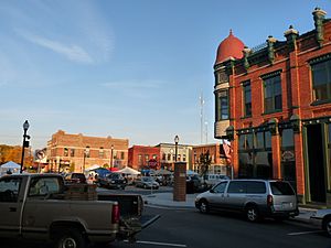
Town square
|
|
| Nickname(s):
Gateway to the Pineries, City of Wonderful Water
|
|

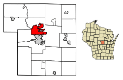
Location of Stevens Point in Portage County, Wisconsin.
|
|
| Country | |
| State | |
| County | Portage |
| Area | |
| • City | 18.41 sq mi (47.68 km2) |
| • Land | 17.17 sq mi (44.47 km2) |
| • Water | 1.24 sq mi (3.21 km2) |
| Elevation | 1,089 ft (332 m) |
| Population
(2020)
|
|
| • City | 25,666 |
| • Density | 1,495.1/sq mi (577.3/km2) |
| • Metro | 70,377 |
| Time zone | UTC−6 (CST) |
| • Summer (DST) | UTC−5 (CDT) |
| Zip code(s) |
54481, 54482
|
| Area code(s) | 715 & 534 |
| FIPS code | 55-77200 |
| GNIS feature ID | 1574878 |
| Website | stevenspoint.com |
Stevens Point is a city in Wisconsin, United States. It is the main city of Portage County. In 2020, about 25,666 people lived there. Stevens Point is the center of a larger area with about 70,377 people.
The city was officially created in 1858. It is home to the University of Wisconsin–Stevens Point and a campus of Mid-State Technical College.
Contents
History
Stevens Point was once part of the lands of the Menominee people. In 1836, a three-mile strip along the Wisconsin River was given to the United States. The Menominee made their last treaty with the U.S. in 1854. They then moved to a special area on the Wolf River. In the Menominee language, the area is called Pasīpahkīhnen. This means "It juts out as land" or "point of land."
The city got its name from George Stevens. He ran a store and supply business on the Wisconsin River. This was during a time when a lot of logging happened in Wisconsin. Loggers used the river to float trees to sell them. The river bends slightly here, making it a good stopping point for loggers. The town grew from Stevens's business and was named after him.
In 1845, the postal service came to Stevens Point. This made communication better. The city's population grew three times bigger in the next 20 years.
In 1847, the first map of Stevens Point was drawn. This map included the Public Square. The town square was a place near the Wisconsin River. Professionals, craftspeople, business people, and loggers met there. They gathered before their river trips, which brought money to the area. As years passed, the area around the town square grew as logging increased.
Most early buildings were made of wood. Many fires happened between 1850 and 1890. Around 1880, people started building with brick and sandstone.
Geography
Stevens Point covers about 18.41 square miles (47.68 square kilometers). About 17.17 square miles (44.47 square kilometers) is land. About 1.24 square miles (3.21 square kilometers) is water. The towns of Plover, Whiting, and Park Ridge are next to the city. The main rivers are the Wisconsin River to the west and the Plover River. The Plover River joins the Wisconsin River from the northeast. It provides much of the city's water.
Demographics
| Historical population | |||
|---|---|---|---|
| Census | Pop. | %± | |
| 1860 | 1,538 | — | |
| 1870 | 1,895 | 23.2% | |
| 1880 | 4,445 | 134.6% | |
| 1890 | 7,896 | 77.6% | |
| 1900 | 9,524 | 20.6% | |
| 1910 | 8,692 | −8.7% | |
| 1920 | 11,371 | 30.8% | |
| 1930 | 13,623 | 19.8% | |
| 1940 | 15,777 | 15.8% | |
| 1950 | 16,564 | 5.0% | |
| 1960 | 17,837 | 7.7% | |
| 1970 | 23,479 | 31.6% | |
| 1980 | 22,970 | −2.2% | |
| 1990 | 23,006 | 0.2% | |
| 2000 | 24,551 | 6.7% | |
| 2010 | 26,717 | 8.8% | |
| 2020 | 25,666 | −3.9% | |
| source: | |||
2020 Census Information
In 2020, the population was 25,666 people. The city had about 1,495 people per square mile. There were 11,386 homes. Most people (85.6%) were White. Other groups included 4.8% Asian, 2.7% Black, and 0.6% Native American. About 4.1% of the population was Hispanic or Latino.
The average income for a family was $73,009. About 19.3% of the population lived below the poverty line. This included 11.4% of those under 18. Most adults (93.4%) had finished high school. Also, 38.1% had a college degree or higher.
2010 Census Information
In 2010, there were 26,717 people living in Stevens Point. There were 10,598 households. The city had about 1,674 people per square mile. Most people (91.7%) were White. Other groups included 4.7% Asian and 0.9% African American. About 2.6% of the population was Hispanic or Latino.
The average age in the city was 26.5 years. Many residents (31.3%) were between 18 and 24 years old. This is because of the colleges in the city.
Religion in Stevens Point
Many different churches are in Stevens Point. The mother house of the Sisters of St. Joseph of the Third Order of St. Francis was here. Catholic churches include Holy Spirit, St. Stephen, St. Casimir, St. Peter, and St. Joseph. There are also Lutheran and other Protestant churches. Members of the Baháʼí Faith also live here.
The first religious service was held near the town square in 1847. By 1900, Catholic, Lutheran, Methodist, and Jewish places of worship were in the downtown area.
Economy
Many companies have offices or headquarters in Stevens Point. Some major employers are Pixelle Specialty Solutions (a paper mill) and Sentry Insurance. Other companies include Travel Guard (travel insurance) and Skyward (software design). Delta Dental of Wisconsin and the Stevens Point Brewery are also important.
Companies with their main offices in Stevens Point include Sentry Insurance and Skyward. Large companies like Associated Bank and AIG have regional offices here.
The city has several business areas. These include Crossroads Commons and the Portage County Business Park.
Arts and Culture
Stevens Point has a community theater group called cwACT. There is also a children's museum. The Portage County Historical Society runs several museums. This includes the Beth Israel Congregation Museum, which used to be a synagogue.
The Central Wisconsin Symphony Orchestra (CWSO) performs four concerts each year.
Many events happen near the downtown area. The town square was rebuilt in 2011. Events include the annual Riverfront Rendezvous and Corn on the Curb. There is also a Fourth of July parade and a sculpture park celebration.
The downtown area is a "Wisconsin Main Street Community." It has unique shops and restaurants. Buildings downtown are made from materials like Lake Superior limestone and brick. City offices and banks are also downtown. The downtown area also has nightlife and a farmers' market. The farmers' market has sold fresh produce for over 100 years. It is open from early summer to early fall.
Stevens Point hosts the world's largest trivia contest. It is run by UWSP's radio station, WWSP-FM. The contest usually has over 12,000 players on more than 400 teams. It lasts 54 hours, from Friday to Sunday, every April.
The city was the setting for the first three seasons of the Disney Channel TV show Liv and Maddie. The bluegrass band Horseshoes and Hand Grenades started in Stevens Point.
Parks and Recreation
The city has 20 parks. It also has a 26-mile (42 km) bicycle and jogging trail called the Green Circle Trail. This trail goes around and through the city. The Ice Age National Scenic Trail also passes through Stevens Point.
There is an 18-hole public golf course called SentryWorld. It is at the Sentry Insurance Home Office. The Schmeeckle Reserve is a nature area on the University of Wisconsin–Stevens Point campus. Next to Schmeeckle is the Stevens Point Sculpture Park. It shows art by local artists.
Goerke Park has a football stadium. High school and college athletes use it for games. It also has an outdoor track.
The Backwaters Paddle Quest canoe adventure challenge happens in Stevens Point. It has been held on the Wisconsin River since 2002. People paddle their canoes for two days. They visit checkpoints and meet characters who act out a story.
Iverson Park is a park on the Green Circle Trail and Plover River. It covers over 100 acres. It has a swimming area, hiking trails, and rentals for canoes and other activities.
Education
The Stevens Point Area Public School District serves the city. There are also Pacelli Catholic Schools and Point of Discovery School.
Public elementary schools include Bannach, Jefferson School for the Arts, and McKinley. There are two junior high schools, Ben Franklin and P. J. Jacobs. The two high schools are Stevens Point Area Senior High (SPASH) and Charles F. Fernandez Center.
Private schools include St. Paul Lutheran School and Pacelli High School.
Stevens Point is home to the Portage County Public Library. It offers learning resources for all ages.
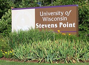
The University of Wisconsin–Stevens Point (UWSP) is in the city. About 7,313 college students attend UWSP. Mid-State Technical College (MSTC) is also in Stevens Point.
Transportation
Major Highways
Five main roads go through Stevens Point:
 I-39 goes north to Wausau and south to Madison.
 US 10 goes east to Manitowoc and west to Fargo.
 US 51 goes north to Hurley and south to Baton Rouge, Louisiana.
 WIS 54 goes east to Green Bay and west to Onalaska.
 WIS 66 goes east to Rosholt and west to Wisconsin Rapids.
Airports
Two airports serve the city. Central Wisconsin Airport (KCWA) is for bigger flights. It is between Stevens Point and Wausau. Smaller planes and charter flights use the local Stevens Point Municipal Airport (KSTE).
Public Transit
The Stevens Point Transit system provides public buses. Lamers Bus Lines and Van Galder Bus Company offer bus service between cities.
Notable People
- Cole Caufield, NHL player
- Suzy Favor Hamilton, Olympic runner
- Sam Hauser, NBA player
- Joel Hodgson, creator of Mystery Science Theater 3000
- Kathy Kinney, actress and comedian
- Ross Kolodziej, NFL player and coach
- Janel McCarville, WNBA player
- Patrick Rothfuss, author
- Ryan Ramczyk, NFL player
- Chris Solinsky, distance runner
- Garrett Weber-Gale (born 1985), Olympic swimmer
- Peter Weller, actor and director
Sister Cities
- Gulcz, Greater Poland Voivodeship, Poland
- Rostov Veliky, Yaroslavl Oblast, Russia
See also
 In Spanish: Stevens Point para niños
 | Audre Lorde |
 | John Berry Meachum |
 | Ferdinand Lee Barnett |


