
Tirunelveli district facts for kids
Quick facts for kids
Tirunelveli district
|
|
|---|---|

Thamirabarani River from Authoor Bridge
|
|
| Nickname(s):
Halwa City
|
|
.svg)
Location in Tamil Nadu
|
|
| Country | |
| State | |
| District formed on | 1 September 1790 |
| Headquarters | Tirunelveli |
| Talukas | Ambasamudram, Nanguneri, Palayamkottai, Radhapuram, Tirunelveli, Cheranmahadevi, Manur, Thisayanvilai |
| Government | |
| • Type | District Administration |
| • Body | Tirunelveli District Collectorate |
| Area | |
| • Total | 3,907 km2 (1,509 sq mi) |
| Area rank | 1 |
| Population
(2011)
|
|
| • Total | 1,636,438 |
| • Density | 410.5/km2 (1,063/sq mi) |
| Languages | |
| • Official | Tamil |
| Time zone | UTC+5:30 (IST) |
| PIN |
627***
|
| Telephone code | 0462 |
| Vehicle registration | TN-72 (Tirunelveli City) and TN-72A (Valliyur Region) and TN-76A (Ambasamudram) |
| Precipitation | 814.8 millimetres (32.08 in) |
| Largest city | Tirunelveli |
| Sex ratio | M-49%/F-51% ♂/♀ |
| Literacy | 82.90% (2011) |
| Legislature type | elected |
| Legislature Strength | 5 |
| Avg. summer temperature | 37 °C (99 °F) |
| Avg. winter temperature | 22 °C (72 °F) |
Tirunelveli district is a cool place in Tamil Nadu, India. It's one of the 38 districts in the state. The main city and headquarters is Tirunelveli. This district was created on September 1, 1790. It was formed by the British East India Company.
Back then, it included areas that are now Thoothukudi, Tenkasi, and parts of Virudhunagar and Ramanathapuram district. In 2011, the district (before it was split again) had over 3 million people.
Contents
History of Tirunelveli District
| Historical population | ||
|---|---|---|
| Year | Pop. | ±% p.a. |
| 1901 | 982,363 | — |
| 1911 | 1,061,965 | +0.78% |
| 1921 | 1,154,547 | +0.84% |
| 1931 | 1,242,552 | +0.74% |
| 1941 | 1,376,604 | +1.03% |
| 1951 | 1,547,268 | +1.18% |
| 1961 | 1,677,309 | +0.81% |
| 1971 | 1,972,220 | +1.63% |
| 1981 | 2,203,462 | +1.11% |
| 1991 | 2,481,880 | +1.20% |
| 2001 | 2,703,492 | +0.86% |
| 2011 | 3,077,233 | +1.30% |
| source: | ||
This area has a long history. When the Pandyan Dynasty ruled, it was called Thenpandiyanadu. Tirunelveli was their second capital city.
Later, the Chola dynasty named it Mudikonda Cholamandalam. The Madurai Nayaks called it Tirunelveli Seemai. When the British East India Company took over, it became Tinnevelly district. This district was much larger than today's Tirunelveli.
In 1910, Ramanathapuram District was created. It took parts from Madurai and Tirunelveli districts. This included areas that are now part of Virudhunagar District.
After India became independent, Tirunelveli District was split. This happened on October 20, 1986. It formed Nellai-Kattabomman district (Tirunelveli) and Chidambaranar district (Tuticorin). Later, the government decided to name districts after their main towns. So, Tirunelveli-Kattabomman became just Tirunelveli.
On July 18, 2019, the district was split again. A new district called Tenkasi district was formed. Tenkasi became its capital city.
Geography and Climate


Tirunelveli district is in the southern part of Tamil Nadu. It shares borders with other districts. To the north is Tenkasi district. To the south is Kanyakumari District. Thoothukudi District is to the east. To the west are Thiruvananthapuram district and Kollam district in Kerala.
The district covers an area of 3,907 square kilometres (1,509 sq mi). It lies between 8°05' and 9°30' north latitude. It is also between 77°05' and 78°25' east longitude.
Climate and Rivers
Tirunelveli gets rain throughout the year. It benefits from both the northeast and southwest monsoons. In 2005 and 2006, it received 953.1 millimetres (37.52 in) of rain. Most of this rain came from the northeast monsoon.
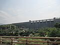
Many rivers flow through the district. They start in the Western Ghats. The Pachaiyar River flows into the Thamirabarani River. The Thamirabarani and Manimuthar Rivers have many dams. These dams create reservoirs. They provide water for farming and making electricity. The Thamirabarani River is very important for farming in the area.
Administration and Government
Tirunelveli city is the main administrative center. It is part of the Tirunelveli Lok Sabha constituency.
Divisions and Taluks
The district is divided into Revenue Divisions and Taluks.
- Tirunelveli Revenue Division includes:
- Tirunelveli
- Palayamkottai
- Manur
- Cheranmahadevi Revenue Division includes:
- Cheranmadevi
- Ambasamudram
- Nanguneri
- Radhapuram
- Thisayanvilai
There are also proposals for new taluks:
- Pappakudi
- Kalakkad
- Valliyur
Local Bodies
Tirunelveli has one Municipal Corporation:
- Tirunelveli
It also has several Municipalities:
- Ambasamudram
- Vikramasingapuram
- Kalakkad
And many Town Panchayats:
- Cheranmahadevi
- Eruvadi
- Gopalasamudram
- Kallidaikurichi
- Manimutharu
- Melacheval
- Moolakaraipatti
- Mukkudal
- Nanguneri
- Naranammalpuram
- Panagudi
- Pathamadai
- Sankarnagar
- Thirukkurungudi
- Thisayanvilai
- Veeravanallur
- Valliyur (Vadakkuvalliyur)
Assembly Constituencies
After Tenkasi District was formed, Tirunelveli District now has one Lok Sabha constituency. It also has seven Assembly constituencies:
- Alangulam
- Tirunelveli
- Palayamkottai
- Ambasamudram
- Nanguneri
- Radhapuram
People and Population
According to the 2011 census, the Tirunelveli district (before it was split) had a population of 3,077,233 people. There were 1,023 females for every 1,000 males. This is higher than the national average.
After the district was split, Tirunelveli district had 1,636,438 people. About 55% of the people live in cities. Tamil is the main language spoken here. About 98% of the people speak Tamil.
| Religions in residual Tirunelveli district (2011) | ||||
|---|---|---|---|---|
| Religion | Percent | |||
| Hindu | 74.85% | |||
| Christian | 15.14% | |||
| Muslim | 9.77% | |||
| Other or not stated | 0.24% | |||
| Distribution of religions | ||||
Infrastructure and Connectivity
The district has good roads and railways. Tirunelveli city is the main transport hub. There are no airports in the district itself. The closest airports are in Tuticorin (32 kilometres (20 mi) away), Madurai (150 kilometres (93 mi)), and Thiruvananthapuram (158 kilometres (98 mi)). The district has 27 railway stations.
Roads and Railways
Here's how long the roads and railways are:
| Roads | National highways | State highways | Corporation and Municipalities Roads | Panchayat Union and Panchayat Road | Town Panchayat and Townships Road | Others (forest roads) |
|---|---|---|---|---|---|---|
| Length (km.) | 174.824 | 442.839 | 1,001.54 | 1,254.10 and 1,658.35 | 840.399 | 114.450 |
| Railways | Route length (km) | Track length (km) |
|---|---|---|
| Broad gauge | 257.000 | 495.448 |
| Meter gauge | 0.000 | 0.000 |
Water and Electricity
Water for farming comes from canals, wells, tanks, and reservoirs. In 2005–2006, the district had 151 canals. They were 499 kilometres (310 mi) long. There were also 85,701 wells for irrigation. Many wells are used for homes too.
Electricity is supplied by the Tamil Nadu Electricity Board (TNEB). The district has power plants that use water and wind. It's a big producer of wind energy in the state. The Koodankulam Nuclear Power Plant is being built nearby. It also has many windmills for power.
Education and Development
Tirunelveli district has a high literacy rate of 76.97%. This is higher than the state average. In 2005–2006, there were 2,494 schools.
The district has one university, the Manonmaniam Sundaranar University (MSU). There are also many colleges. These include government colleges, government-sponsored colleges, and private colleges.
Schools and Colleges
Tirunelveli has 25 arts and science colleges. There are also 3 medical colleges and 20 engineering colleges. A law school is also present. For younger students, there are 1,501 primary schools. There are 431 middle schools and 185 higher secondary schools.
Manonmaniam Sundaranar University was started in 1990. It works with 102 colleges. The first colleges in the district were Madurai Diraviam Thayumanavar Hindu College and St. John's College, both from 1878. Sarah Tucker College, the first women's college, opened in 1895.
The Tirunelveli Medical College was set up in 1965. The Government Siddha Medical College opened in 1964. Technical education started early here. In 1844, a school taught girls lace-making. The Government College of Engineering was established in 1981.
Economy and Industries
Tirunelveli has always been an important farming area. The district grows a lot of rice, coconuts, and bananas. It also produces spices and forest products.
Farming and Fishing
The district has many buffaloes. Here are the numbers for livestock and poultry:
| Cattle | Buffalo | Sheep | Goats | Pigs | Horses and Ponies | Donkeys | Rabbits | Total livestock | Total poultry |
|---|---|---|---|---|---|---|---|---|---|
| 418,694 | 78,777 | 487,273 | 390,570 | 12,752 | 245 | 961 | 2401 | 67,877 | 1,218,583 |
Since it's near the coast, fishing is also important. In 2005–2006, the district caught 1,874 tonnes of fish from inland waters. It caught 7,014 tonnes of fish from the sea.
Industries and Minerals
India Cements Limited, a big cement company, started here in 1949. The district is rich in minerals. There are 407 mines and quarries. Limestone, granite, and garnet sand are some of the minerals found.
Major industries include textiles, food, and forestry products. A special industrial zone (SEZ) was started in Nanguneri in 2001. Plans include factories for medicine, windmill parts, and televisions. The government wants to attract more businesses and workers to this area.
Fun Places to Visit

Manjolai Hills
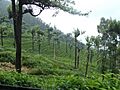
The Manjolai area is a beautiful spot in the Western Ghats. It is located high up, between 1,000 metres (3,300 ft) and 1,500 metres (4,900 ft). It's part of the Kalakad Mundanthurai Tiger Reserve. You can find tea plantations here. There are also small villages and the Upper Kodaiyar Dam. Kuthiravetti is a windy viewpoint with great views.
The tea plantations are managed by The Bombay Burmah Trading Corporation Ltd. They are on forest land leased from the government. There are three tea estates: Manjolai Estate, Manimutharu Estate, and Oothu Estate. They are at different heights, from 700 metres (2,300 ft) to 1,300 metres (4,300 ft).
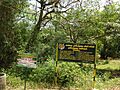
Tiger Reserve
The Kalakkad Mundanthurai Tiger Reserve is a large area of 900 square kilometres (350 sq mi). It was created in 1988. This reserve is about 45 km west of Tirunelveli. It is known as KMTR by researchers who study forests and tigers. Kalakkad is the closest town. Kalakkad has a temple called Malainambi temple with a waterfall.
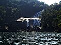
Papanasam
Papanasam is a popular picnic spot. It's about 50 km (31 mi) from Tirunelveli. Tourists love to visit the Thamirabarani River here. Other attractions include Agasthiyar Falls, a Shiva Temple, Papanasam dam, and a power plant.
Bird Sanctuary
Koonthankulam is a small village in Nanguneri Taluk. It's becoming a favorite place for migratory birds. It is only 38 kilometres (24 mi) away. About 35 types of birds come here to breed. Painted storks come from North India and East European Countries. Flamingoes fly in mainly from the Rann of Kutch. They hatch and raise their young in the village.
Famous Temples
The Nellaiappar Temple is in Tirunelveli. It's an old temple with a rich history. It's famous for its musical pillars and carved figures. The closest airport is Tuticorin Airport (TCR). It's a 30-minute drive from Tirunelveli.
The Navaneethakrishnan Temple is at Melasevel Village. It's about 16 km (9.9 mi) from Tirunelveli. This temple is around 730 years old. The Adhithyavarneshwar Temple, dedicated to Lord Shiva, is also famous here. Twice a year, the sun's rays shine directly on the Lingam in the morning. Many festivals are held at these temples.
Notable People
- T. V. Sundaram Iyengar, who started the TVS group.
- Shiv Nadar, who founded HCL.
- V. G. Panneerdas, who started the VGP group.
- P. Rajagopal, who founded Saravana Bhavan.
- N.Srinivasan, an Indian industrialist. He used to be the Chairman of the International Cricket Council (ICC). He was also the President of the BCCI. He is the managing director of India Cements Limited.
- S.Gnanathiraviam, who founded Annai Groups. He is a Member of Parliament for Tirunelveli.
Sports People
- Vijay Shankar (cricketer)
Images for kids
-
Manjolai hills
-
Vanatheertham falls at Papanasam
-
Kalakkad Mundanthurai Tiger Reserve
-
Manimuthar Dam
-
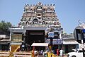
Swamy Nellaiappar temple at Tirunelveli town in Tirunelveli City
-
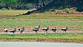
Koodankulam Bird Sanctuary
-
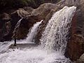
Manimuthar falls
-
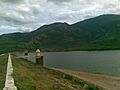
Gadananathi River or Karunai River Dam


_at_Koonthakulam_Bird_Sanctuary.jpg)


See also
 In Spanish: Distrito de Tirunelveli para niños
